Property Record
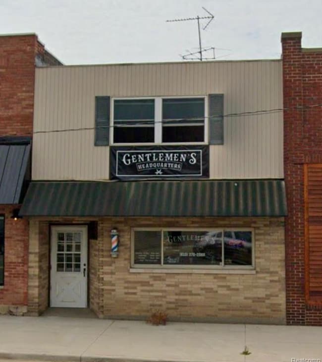
4018 Huron St, North Branch, MI 48461


NEARBY LISTINGS FOR SALE OR LEASE
-
-
View all North Branch listings for lease on LoopNet.com
Property Detail
4018 Huron St
Detroit
16 51 500 000 00 DDA VILLAGE OF NORTH BRANCH HENRY BANKERS ADDITION TO THE VILLAGE OF BEECHVILLE E 26.33 FEET OF W 38.33 FEET
Detroit-Warren-Dearborn, MI
Lapeer
046-321-002-00
Michigan
Commercialacreage
2
2024
0.07 AC
2025
St Clair & Lapeer Counties
332500
DEMOGRAPHICS near 4018 Huron St
1 Mile
3 Mile
5 Mile
2024 Total Population
1,412
3,070
6,113
2029 Population
1,429
3,084
6,092
Pop Growth 2024-2029
+ 1.20%
+ 0.46%
(0.34%)
Average Age
39
40
41
2024 Total Households
529
1,148
2,266
HH Growth 2024-2029
+ 1.32%
+ 0.44%
(0.35%)
Median Household Inc
$49,511
$61,927
$67,175
Avg Household Size
2.60
2.60
2.70
2024 Avg HH Vehicles
2.00
2.00
2.00
Median Home Value
$157,142
$170,116
$178,182
Median Year Built
1972
1974
1976
Nearby Places
Map Layers
Map Styles
 Street
 Aerial
- Restaurants
- Banks
- Shops
- Fitness
- Groceries
PUBLIC TRANSPORTATION
AIRPORT
Bishop International
DRIVE
WALK
Distance
Bishop International
71 min
46.8 mi
SALE & LEASE HISTORY
LISTING DATE
SALE/LEASE

May 22, 2024
For Lease
Mar 14, 2024
For Sale
Nearby Properties
Address
Land Use
TOTAL SIZE
Lot Size
Zoning
Address
Land Use
TOTAL SIZE
Lot Size
Zoning
3,348 SF
27.20 AC
RMH MO
Address
Land Use
TOTAL SIZE
Lot Size
Zoning
35,607 SF
5.09 AC
I-1 LI
Address
Land Use
TOTAL SIZE
Lot Size
Zoning
15,000 SF
A-R AG
Address
Land Use
TOTAL SIZE
Lot Size
Zoning
18,080 SF
2.44 AC
A-R AG
Address
Land Use
TOTAL SIZE
Lot Size
Zoning
2,046 SF
176 AC
A-R AG
Address
Land Use
TOTAL SIZE
Lot Size
Zoning
26,104 SF
2.40 AC
R SI
Address
Land Use
TOTAL SIZE
Lot Size
Zoning
28,216 SF
2.88 AC
RM MU
Address
Land Use
TOTAL SIZE
Lot Size
Zoning
2,162 SF
160 AC
A-R AG
Address
Land Use
TOTAL SIZE
Lot Size
Zoning
1,378 SF
20 AC
A-R AG
Address
Land Use
TOTAL SIZE
Lot Size
Zoning
209.90 AC
UNZONED
Address
Land Use
TOTAL SIZE
Lot Size
Zoning
45,856 SF
5.62 AC
I IN
Address
Land Use
TOTAL SIZE
Lot Size
Zoning
75 AC
UNZONED
Address
Land Use
TOTAL SIZE
Lot Size
Zoning
93.40 AC
A-R AG
Address
Land Use
TOTAL SIZE
Lot Size
Zoning
2,097 SF
157.11 AC
UNZONED
Address
Land Use
TOTAL SIZE
Lot Size
Zoning
160 AC
UNZONED
Address
Land Use
TOTAL SIZE
Lot Size
Zoning
3,309 SF
80 AC
A-R AG
Address
Land Use
TOTAL SIZE
Lot Size
Zoning
2,569 SF
58 AC
A-R AG
Address
Land Use
TOTAL SIZE
Lot Size
Zoning
27,500 SF
I IN
Address
Land Use
TOTAL SIZE
Lot Size
Zoning
205.06 AC
UNZONED
Address
Land Use
TOTAL SIZE
Lot Size
Zoning
1,931 SF
96 AC
A-R AG
Address
Land Use
TOTAL SIZE
Lot Size
Zoning
9,100 SF
3.62 AC
C CO
Address
Land Use
TOTAL SIZE
Lot Size
Zoning
2,434 SF
80.32 AC
A-R AG
Address
Land Use
TOTAL SIZE
Lot Size
Zoning
9,600 SF
2.83 AC
C CO
Address
Land Use
TOTAL SIZE
Lot Size
Zoning
2,054 SF
90 AC
A-R AG
Address
Land Use
TOTAL SIZE
Lot Size
Zoning
1,400 SF
111.43 AC
A-R AG
Address
Land Use
TOTAL SIZE
Lot Size
Zoning
2,240 SF
73 AC
A-R AG
Address
Land Use
TOTAL SIZE
Lot Size
Zoning
1,840 SF
115.98 AC
R-1
Address
Land Use
TOTAL SIZE
Lot Size
Zoning
1,222 SF
121.21 AC
UNZONED
Address
Land Use
TOTAL SIZE
Lot Size
Zoning
136.60 AC
A-R AG
Address
Land Use
TOTAL SIZE
Lot Size
Zoning
3,692 SF
80 AC
A-R AG
The World's #1 Commercial Real Estate Marketplace
Connect with us
© 2025 CoStar Group
The information above has been obtained from sources believed reliable. While we do not doubt its accuracy we have not verified it and make no guarantee, warranty or representation about it. It is your responsibility to independently confirm its accuracy and completeness. Any projections, opinions, assumptions, or estimates used are for example only and do not represent the current or future performance of the property. The value of this transaction to you depends on tax and other factors which should be evaluated by your tax, financial, and legal advisors. You and your advisors should conduct a careful, independent investigation of the property to determine to your satisfaction the suitability of the property for your needs.