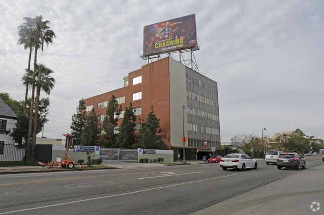
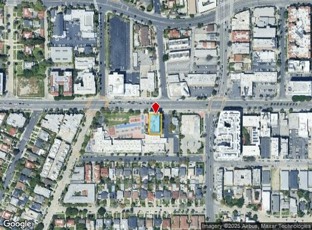
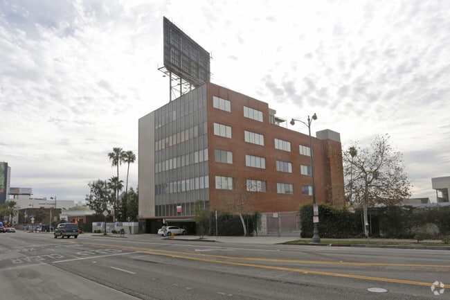
Property Record
4032 Wilshire Blvd, Los Angeles, CA 90010

Current Lease Availabilities
NEARBY LISTINGS FOR SALE OR LEASE
Property Detail
4032 Wilshire Blvd
Los Angeles-Long Beach-Glendale, CA
Norton Place
5092-008-005
NORTON PLACE W 25 FT OF LOT 6 AND ALL OF LOT 7 BLK 1
Officebuilding
Los Angeles
X
California
06037C1612G
6,7
2024
0.22 AC
2025
Park Mile
212610
Los Angeles
29,150 SF
DEMOGRAPHICS near 4032 Wilshire Blvd
1 Mile
3 Mile
5 Mile
2024 Total Population
75,837
613,205
1,188,969
2029 Population
74,492
599,184
1,159,394
Pop Growth 2024-2029
(1.77%)
(2.29%)
(2.49%)
Average Age
40
39
39
2024 Total Households
33,038
248,257
493,991
HH Growth 2024-2029
(1.96%)
(2.35%)
(2.44%)
Median Household Inc
$53,469
$53,536
$61,468
Avg Household Size
2.20
2.30
2.30
2024 Avg HH Vehicles
1.00
1.00
1.00
Median Home Value
$1,055,533
$996,249
$1,002,918
Median Year Built
1965
1959
1959
Nearby Places
- Restaurants
- Banks
- Shops
- Fitness
- Groceries
PUBLIC TRANSPORTATION
TRANSIT/SUBWAY
Wilshire/Western Station (Purple Line - Los Angeles County Metropolitan Transportation Authority (Metro))
DRIVE
WALK
Distance
Wilshire/Western Station (Purple Line - Los Angeles County Metropolitan Transportation Authority (Metro))
1 min
7 min
0.4 mi
Wilshire/Normandie Station (Purple Line - Los Angeles County Metropolitan Transportation Authority (Metro))
DRIVE
WALK
Distance
Wilshire/Normandie Station (Purple Line - Los Angeles County Metropolitan Transportation Authority (Metro))
2 min
16 min
0.8 mi
COMMUTER RAIL
DRIVE
WALK
Distance
11 min
6.1 mi
Union Station (91 Line - Southern California Regional Rail Authority (Metrolink), Antelope Valley Line - Southern California Regional Rail Authority (Metrolink), Orange County Line - Southern California Regional Rail Authority (Metrolink), Riverside Line - Southern California Regional Rail Authority (Metrolink), San Bernardino Line - Southern California Regional Rail Authority (Metrolink), Ventura County Line - Southern California Regional Rail Authority (Metrolink))
DRIVE
WALK
Distance
Union Station (91 Line - Southern California Regional Rail Authority (Metrolink), Antelope Valley Line - Southern California Regional Rail Authority (Metrolink), Orange County Line - Southern California Regional Rail Authority (Metrolink), Riverside Line - Southern California Regional Rail Authority (Metrolink), San Bernardino Line - Southern California Regional Rail Authority (Metrolink), Ventura County Line - Southern California Regional Rail Authority (Metrolink))
15 min
6.3 mi
AIRPORT
Los Angeles International
DRIVE
WALK
Distance
Los Angeles International
22 min
11.5 mi
Bob Hope
DRIVE
WALK
Distance
Bob Hope
21 min
12.3 mi
Long Beach (Daugherty Field)
DRIVE
WALK
Distance
Long Beach (Daugherty Field)
35 min
25.5 mi
Nearby Properties
Address
Land Use
TOTAL SIZE
Lot Size
Zoning
Address
Land Use
TOTAL SIZE
Lot Size
Zoning
930,249 SF
7.39 AC
LAC2
Address
Land Use
TOTAL SIZE
Lot Size
Zoning
1,002,990 SF
8.42 AC
LAC4
Address
Land Use
TOTAL SIZE
Lot Size
Zoning
252,523 SF
2.26 AC
LAC2
Address
Land Use
TOTAL SIZE
Lot Size
Zoning
709,584 SF
1.80 AC
LAPB
Address
Land Use
TOTAL SIZE
Lot Size
Zoning
161,046 SF
6.88 AC
LAM1
Address
Land Use
TOTAL SIZE
Lot Size
Zoning
728,063 SF
2.08 AC
LAC4
Address
Land Use
TOTAL SIZE
Lot Size
Zoning
67,126 SF
48.09 AC
LAM1
Address
Land Use
TOTAL SIZE
Lot Size
Zoning
472,363 SF
3.24 AC
LAC4
Address
Land Use
TOTAL SIZE
Lot Size
Zoning
515,531 SF
14.65 AC
LAC2
Address
Land Use
TOTAL SIZE
Lot Size
Zoning
641,453 SF
2.93 AC
LAC4
Address
Land Use
TOTAL SIZE
Lot Size
Zoning
497,377 SF
3.29 AC
LAC4
Address
Land Use
TOTAL SIZE
Lot Size
Zoning
793,274 SF
7.80 AC
LAR4
Address
Land Use
TOTAL SIZE
Lot Size
Zoning
110,580 SF
6.88 AC
LAC2
Address
Land Use
TOTAL SIZE
Lot Size
Zoning
724,958 SF
5.88 AC
LAC2
Address
Land Use
TOTAL SIZE
Lot Size
Zoning
520,825 SF
2.13 AC
LAC2
Address
Land Use
TOTAL SIZE
Lot Size
Zoning
289,633 SF
1.55 AC
LAP
Address
Land Use
TOTAL SIZE
Lot Size
Zoning
453,182 SF
2.76 AC
LAC4
Address
Land Use
TOTAL SIZE
Lot Size
Zoning
255,868 SF
9.58 AC
WDC2C*
Address
Land Use
TOTAL SIZE
Lot Size
Zoning
8.93 AC
LAC2
Address
Land Use
TOTAL SIZE
Lot Size
Zoning
679,557 SF
6.41 AC
LAC2
Address
Land Use
TOTAL SIZE
Lot Size
Zoning
786,423 SF
11.74 AC
LAC2
Address
Land Use
TOTAL SIZE
Lot Size
Zoning
556,235 SF
4.22 AC
LAC4
Address
Land Use
TOTAL SIZE
Lot Size
Zoning
406,948 SF
8.04 AC
LAC2
Address
Land Use
TOTAL SIZE
Lot Size
Zoning
341,221 SF
1.84 AC
LAC4
Address
Land Use
TOTAL SIZE
Lot Size
Zoning
490,689 SF
3.60 AC
LAM1
Address
Land Use
TOTAL SIZE
Lot Size
Zoning
256,032 SF
4.69 AC
LAC4
Address
Land Use
TOTAL SIZE
Lot Size
Zoning
366,349 SF
2.98 AC
WDC2C*
Address
Land Use
TOTAL SIZE
Lot Size
Zoning
216,433 SF
1.38 AC
LAR5
Address
Land Use
TOTAL SIZE
Lot Size
Zoning
320,944 SF
1.97 AC
LAC4
Address
Land Use
TOTAL SIZE
Lot Size
Zoning
264,720 SF
4.69 AC
LAC4
The World's #1 Commercial Real Estate Marketplace
Connect with us
© 2025 CoStar Group
The information above has been obtained from sources believed reliable. While we do not doubt its accuracy we have not verified it and make no guarantee, warranty or representation about it. It is your responsibility to independently confirm its accuracy and completeness. Any projections, opinions, assumptions, or estimates used are for example only and do not represent the current or future performance of the property. The value of this transaction to you depends on tax and other factors which should be evaluated by your tax, financial, and legal advisors. You and your advisors should conduct a careful, independent investigation of the property to determine to your satisfaction the suitability of the property for your needs.