Property Record
4033 Geer Hwy, Cleveland, SC 29635
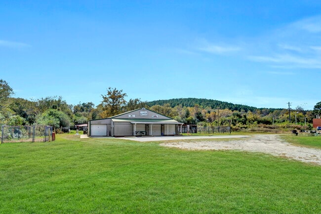
This Property Is For Sale
NEARBY LISTINGS FOR SALE OR LEASE
-
-
View all Cleveland listings for sale on LoopNet.com
Property Detail
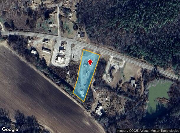
4033 Geer Hwy
Greenville-Anderson-Mauldin, SC
SC HWY 276 & SC HWY 11
0673.04-01-018.05
Greenville
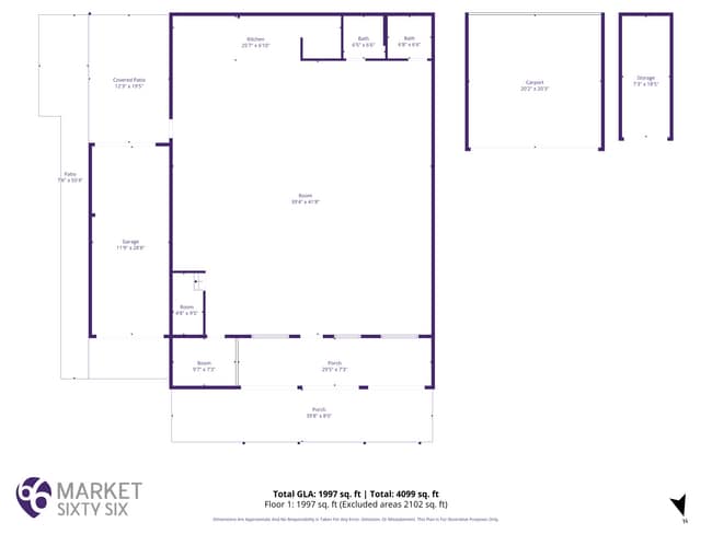
Storebuilding
South Carolina
A
018.05
45045C0200E
1.80 AC
2024
Travelers Rest
2024
Greenville/Spartanburg
004101
DEMOGRAPHICS near 4033 Geer Hwy
1 Mile
3 Mile
5 Mile
2024 Total Population
188
2,898
8,346
2029 Population
208
3,210
9,216
Pop Growth 2024-2029
+ 10.64%
+ 10.77%
+ 10.42%
Average Age
44
44
44
2024 Total Households
75
1,179
3,405
HH Growth 2024-2029
+ 10.67%
+ 11.03%
+ 10.69%
Median Household Inc
$66,750
$65,970
$64,453
Avg Household Size
2.40
2.40
2.40
2024 Avg HH Vehicles
2.00
2.00
2.00
Median Home Value
$246,666
$212,418
$241,394
Median Year Built
1993
1992
1993
Nearby Places
- Restaurants
- Banks
- Shops
- Fitness
- Groceries
PUBLIC TRANSPORTATION
AIRPORT
Greenville Spartanburg International
DRIVE
WALK
Distance
Greenville Spartanburg International
49 min
27.8 mi
Asheville Regional
DRIVE
WALK
Distance
Asheville Regional
45 min
35.2 mi
Freight Ports
North Charleston Terminal
DRIVE
WALK
Distance
North Charleston Terminal
262 min
222.3 mi
Nearby Properties
Address
Land Use
TOTAL SIZE
Lot Size
Zoning
Address
Land Use
TOTAL SIZE
Lot Size
Zoning
822 AC
UNZONED
Address
Land Use
TOTAL SIZE
Lot Size
Zoning
847.64 AC
UNZONED
Address
Land Use
TOTAL SIZE
Lot Size
Zoning
272.60 AC
UNZONED
Address
Land Use
TOTAL SIZE
Lot Size
Zoning
66.66 AC
UNZONED
Address
Land Use
TOTAL SIZE
Lot Size
Zoning
900 SF
5.82 AC
UNZONED
Address
Land Use
TOTAL SIZE
Lot Size
Zoning
2.39 AC
UNZONED
Address
Land Use
TOTAL SIZE
Lot Size
Zoning
18.50 AC
UNZONED
Address
Land Use
TOTAL SIZE
Lot Size
Zoning
16.30 AC
UNZONED
Address
Land Use
TOTAL SIZE
Lot Size
Zoning
574 SF
1.16 AC
UNZONED
Address
Land Use
TOTAL SIZE
Lot Size
Zoning
6.40 AC
UNZONED
Address
Land Use
TOTAL SIZE
Lot Size
Zoning
12.08 AC
UNZONED
Address
Land Use
TOTAL SIZE
Lot Size
Zoning
2.99 AC
UNZONED
Address
Land Use
TOTAL SIZE
Lot Size
Zoning
2 AC
UNZONED
Address
Land Use
TOTAL SIZE
Lot Size
Zoning
2.01 AC
UNZONED
Address
Land Use
TOTAL SIZE
Lot Size
Zoning
2.97 AC
UNZONED
Address
Land Use
TOTAL SIZE
Lot Size
Zoning
0.82 AC
UNZONED
Address
Land Use
TOTAL SIZE
Lot Size
Zoning
1.78 AC
UNZONED
Address
Land Use
TOTAL SIZE
Lot Size
Zoning
1.67 AC
UNZONED
Address
Land Use
TOTAL SIZE
Lot Size
Zoning
2.82 AC
UNZONED
Address
Land Use
TOTAL SIZE
Lot Size
Zoning
7.19 AC
UNZONED
Address
Land Use
TOTAL SIZE
Lot Size
Zoning
5.96 AC
UNZONED
Address
Land Use
TOTAL SIZE
Lot Size
Zoning
1.30 AC
UNZONED
Address
Land Use
TOTAL SIZE
Lot Size
Zoning
4 AC
UNZONED
Address
Land Use
TOTAL SIZE
Lot Size
Zoning
1.50 AC
UNZONED
Address
Land Use
TOTAL SIZE
Lot Size
Zoning
0.89 AC
UNZONED
Address
Land Use
TOTAL SIZE
Lot Size
Zoning
2.08 AC
UNZONED
Address
Land Use
TOTAL SIZE
Lot Size
Zoning
3.20 AC
UNZONED
Address
Land Use
TOTAL SIZE
Lot Size
Zoning
8.02 AC
UNZONED
Address
Land Use
TOTAL SIZE
Lot Size
Zoning
1.59 AC
UNZONED
Address
Land Use
TOTAL SIZE
Lot Size
Zoning
3,799 SF
82.90 AC
UNZONED
The World's #1 Commercial Real Estate Marketplace
Connect with us
© 2025 CoStar Group
The information above has been obtained from sources believed reliable. While we do not doubt its accuracy we have not verified it and make no guarantee, warranty or representation about it. It is your responsibility to independently confirm its accuracy and completeness. Any projections, opinions, assumptions, or estimates used are for example only and do not represent the current or future performance of the property. The value of this transaction to you depends on tax and other factors which should be evaluated by your tax, financial, and legal advisors. You and your advisors should conduct a careful, independent investigation of the property to determine to your satisfaction the suitability of the property for your needs.