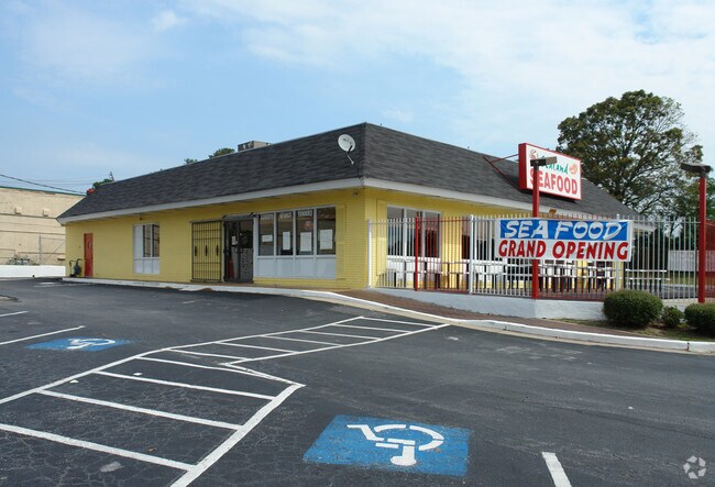
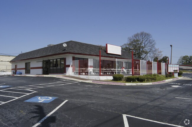
Property Record
4034 Glenwood Rd, Decatur, GA 30032


NEARBY LISTINGS FOR SALE OR LEASE
Property Detail
4034 Glenwood Rd
Atlanta-Sandy Springs-Roswell, GA
Keith & Holland
15-186-03-007
PARCELS 1 2 3
Restaurantdrivein
DeKalb
X
Georgia
13089C0132J
38
2025
0.48 AC
2025
Decatur/East Atl
023101
Atlanta
3,954 SF
DEMOGRAPHICS near 4034 Glenwood Rd
1 Mile
3 Mile
5 Mile
2024 Total Population
10,956
91,184
269,178
2029 Population
11,003
91,630
269,272
Pop Growth 2024-2029
+ 0.43%
+ 0.49%
+ 0.03%
Average Age
41
40
39
2024 Total Households
4,210
36,409
106,525
HH Growth 2024-2029
+ 0.40%
+ 0.66%
+ 0.15%
Median Household Inc
$60,556
$53,285
$63,093
Avg Household Size
2.50
2.40
2.40
2024 Avg HH Vehicles
2.00
2.00
2.00
Median Home Value
$218,208
$249,382
$272,941
Median Year Built
1962
1971
1976
Nearby Places
Map Layers
Map Styles
 Street
 Aerial
- Restaurants
- Banks
- Shops
- Fitness
- Groceries
PUBLIC TRANSPORTATION
AIRPORT
Hartsfield - Jackson Atlanta International
DRIVE
WALK
Distance
Hartsfield - Jackson Atlanta International
26 min
16.4 mi
SALE & LEASE HISTORY
LISTING DATE
SALE/LEASE

Sep 24, 2016
For Sale
Nearby Properties
Address
Land Use
TOTAL SIZE
Lot Size
Zoning
Address
Land Use
TOTAL SIZE
Lot Size
Zoning
78,008 SF
11.16 AC
HR-3
Address
Land Use
TOTAL SIZE
Lot Size
Zoning
123,732 SF
0.51 AC
RM75
Address
Land Use
TOTAL SIZE
Lot Size
Zoning
287,674 SF
17.63 AC
R75: SF RE
Address
Land Use
TOTAL SIZE
Lot Size
Zoning
350,556 SF
46.09 AC
X
Address
Land Use
TOTAL SIZE
Lot Size
Zoning
455,599 SF
43.15 AC
HR-3
Address
Land Use
TOTAL SIZE
Lot Size
Zoning
295,718 SF
25.64 AC
RM85
Address
Land Use
TOTAL SIZE
Lot Size
Zoning
104,501 SF
2.56 AC
X
Address
Land Use
TOTAL SIZE
Lot Size
Zoning
76,500 SF
2.84 AC
X
Address
Land Use
TOTAL SIZE
Lot Size
Zoning
76,654 SF
3.14 AC
C-1
Address
Land Use
TOTAL SIZE
Lot Size
Zoning
234,053 SF
16.80 AC
RM75
Address
Land Use
TOTAL SIZE
Lot Size
Zoning
91,622 SF
18.99 AC
X
Address
Land Use
TOTAL SIZE
Lot Size
Zoning
522,850 SF
41.34 AC
RM75
Address
Land Use
TOTAL SIZE
Lot Size
Zoning
251,327 SF
19.92 AC
X
Address
Land Use
TOTAL SIZE
Lot Size
Zoning
396,905 SF
20.82 AC
RM85
Address
Land Use
TOTAL SIZE
Lot Size
Zoning
137,176 SF
17.59 AC
RM85
Address
Land Use
TOTAL SIZE
Lot Size
Zoning
64,296 SF
0.37 AC
X
Address
Land Use
TOTAL SIZE
Lot Size
Zoning
72,870 SF
12.34 AC
C2
Address
Land Use
TOTAL SIZE
Lot Size
Zoning
71,208 SF
15 AC
X
Address
Land Use
TOTAL SIZE
Lot Size
Zoning
245,053 SF
22.77 AC
RM85
Address
Land Use
TOTAL SIZE
Lot Size
Zoning
253,740 SF
13.33 AC
RM75
Address
Land Use
TOTAL SIZE
Lot Size
Zoning
158,939 SF
14.09 AC
RM85
Address
Land Use
TOTAL SIZE
Lot Size
Zoning
13,114 SF
17.54 AC
RM100
Address
Land Use
TOTAL SIZE
Lot Size
Zoning
256,445 SF
11.71 AC
RM85
Address
Land Use
TOTAL SIZE
Lot Size
Zoning
40,809 SF
2.37 AC
C-1
Address
Land Use
TOTAL SIZE
Lot Size
Zoning
235,787 SF
15.43 AC
RM100
Address
Land Use
TOTAL SIZE
Lot Size
Zoning
221,594 SF
15.90 AC
RM85
Address
Land Use
TOTAL SIZE
Lot Size
Zoning
554,853 SF
42.64 AC
RM75
Address
Land Use
TOTAL SIZE
Lot Size
Zoning
40,913 SF
6.38 AC
M1
Address
Land Use
TOTAL SIZE
Lot Size
Zoning
419,434 SF
21.59 AC
RM85
Address
Land Use
TOTAL SIZE
Lot Size
Zoning
23,072 SF
5.48 AC
C1
The World's #1 Commercial Real Estate Marketplace
Connect with us
© 2026 CoStar Group
The information above has been obtained from sources believed reliable. While we do not doubt its accuracy we have not verified it and make no guarantee, warranty or representation about it. It is your responsibility to independently confirm its accuracy and completeness. Any projections, opinions, assumptions, or estimates used are for example only and do not represent the current or future performance of the property. The value of this transaction to you depends on tax and other factors which should be evaluated by your tax, financial, and legal advisors. You and your advisors should conduct a careful, independent investigation of the property to determine to your satisfaction the suitability of the property for your needs.