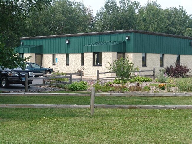
Property Record
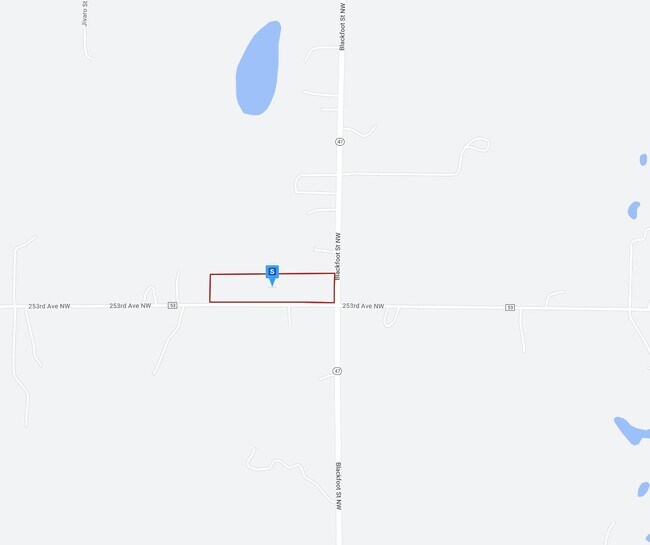
4035 253Rd Ave Nw, Isanti, MN 55040

NEARBY LISTINGS FOR SALE OR LEASE
-
-
View all Isanti listings for sale on LoopNet.com
Property Detail
4035 253Rd Ave Nw
12.118.1100
S 1/2 OF S 1/2 OF SE 1/4 OF SE 1/4 SECTION 18 TOWNSHIP 34 RANGE 24 ISANTI COUNTY MINNESOTA
Multipleuses
Isanti
X
Minnesota
27003C0065E
9.56 AC
2025
Isanti County
2025
Minneapolis/St Paul
130600
Minneapolis-St. Paul-Bloomington, MN-WI
3,240 SF
DEMOGRAPHICS near 4035 253Rd Ave Nw
1 Mile
3 Mile
5 Mile
2024 Total Population
174
6,639
14,100
2029 Population
191
7,012
14,895
Pop Growth 2024-2029
+ 9.77%
+ 5.62%
+ 5.64%
Average Age
43
38
39
2024 Total Households
65
2,423
5,066
HH Growth 2024-2029
+ 10.77%
+ 5.70%
+ 5.76%
Median Household Inc
$90,384
$84,722
$92,431
Avg Household Size
2.50
2.70
2.80
2024 Avg HH Vehicles
3.00
2.00
2.00
Median Home Value
$293,477
$263,500
$288,941
Median Year Built
1983
1995
1994
Nearby Places
Map Layers
Map Styles
 Street
 Aerial
- Restaurants
- Banks
- Shops
- Fitness
- Groceries
Nearby Properties
Address
Land Use
TOTAL SIZE
Lot Size
Zoning
Address
Land Use
TOTAL SIZE
Lot Size
Zoning
228,826 SF
56.32 AC
Address
Land Use
TOTAL SIZE
Lot Size
Zoning
68,136 SF
26.79 AC
Address
Land Use
TOTAL SIZE
Lot Size
Zoning
Address
Land Use
TOTAL SIZE
Lot Size
Zoning
45,652 SF
38.11 AC
Address
Land Use
TOTAL SIZE
Lot Size
Zoning
60,159 SF
6.42 AC
Address
Land Use
TOTAL SIZE
Lot Size
Zoning
894 SF
4 AC
Address
Land Use
TOTAL SIZE
Lot Size
Zoning
20,138 SF
2.61 AC
Address
Land Use
TOTAL SIZE
Lot Size
Zoning
1,292 SF
16.10 AC
Address
Land Use
TOTAL SIZE
Lot Size
Zoning
19,752 SF
2.09 AC
Address
Land Use
TOTAL SIZE
Lot Size
Zoning
7,294 SF
Address
Land Use
TOTAL SIZE
Lot Size
Zoning
30,732 SF
2.44 AC
Address
Land Use
TOTAL SIZE
Lot Size
Zoning
9,556 SF
78.24 AC
SP
Address
Land Use
TOTAL SIZE
Lot Size
Zoning
13,580 SF
1.71 AC
Address
Land Use
TOTAL SIZE
Lot Size
Zoning
11,264 SF
1.85 AC
Address
Land Use
TOTAL SIZE
Lot Size
Zoning
1,632 SF
257 AC
Address
Land Use
TOTAL SIZE
Lot Size
Zoning
Address
Land Use
TOTAL SIZE
Lot Size
Zoning
11,170 SF
1.66 AC
Address
Land Use
TOTAL SIZE
Lot Size
Zoning
3,720 SF
1 AC
Address
Land Use
TOTAL SIZE
Lot Size
Zoning
14,400 SF
1.30 AC
Address
Land Use
TOTAL SIZE
Lot Size
Zoning
5,116 SF
1.02 AC
Address
Land Use
TOTAL SIZE
Lot Size
Zoning
7,396 SF
1.06 AC
Address
Land Use
TOTAL SIZE
Lot Size
Zoning
8,584 SF
0.25 AC
Address
Land Use
TOTAL SIZE
Lot Size
Zoning
5,778 SF
0.84 AC
Address
Land Use
TOTAL SIZE
Lot Size
Zoning
3,708 SF
52.29 AC
Address
Land Use
TOTAL SIZE
Lot Size
Zoning
6,862 SF
0.96 AC
Address
Land Use
TOTAL SIZE
Lot Size
Zoning
2,263 SF
20 AC
SP
Address
Land Use
TOTAL SIZE
Lot Size
Zoning
2,952 SF
4.54 AC
Address
Land Use
TOTAL SIZE
Lot Size
Zoning
7,200 SF
0.96 AC
Address
Land Use
TOTAL SIZE
Lot Size
Zoning
3,261 SF
0.71 AC
Address
Land Use
TOTAL SIZE
Lot Size
Zoning
1,210 SF
30 AC
SR
The World's #1 Commercial Real Estate Marketplace
Connect with us
© 2025 CoStar Group
The information above has been obtained from sources believed reliable. While we do not doubt its accuracy we have not verified it and make no guarantee, warranty or representation about it. It is your responsibility to independently confirm its accuracy and completeness. Any projections, opinions, assumptions, or estimates used are for example only and do not represent the current or future performance of the property. The value of this transaction to you depends on tax and other factors which should be evaluated by your tax, financial, and legal advisors. You and your advisors should conduct a careful, independent investigation of the property to determine to your satisfaction the suitability of the property for your needs.