Property Record
3961 W Sunshine St, Springfield, MO 65807

This Property Is For Sale
Current Lease Availabilities
Property Detail
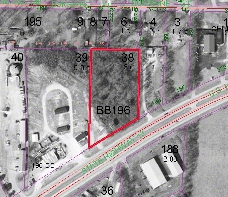
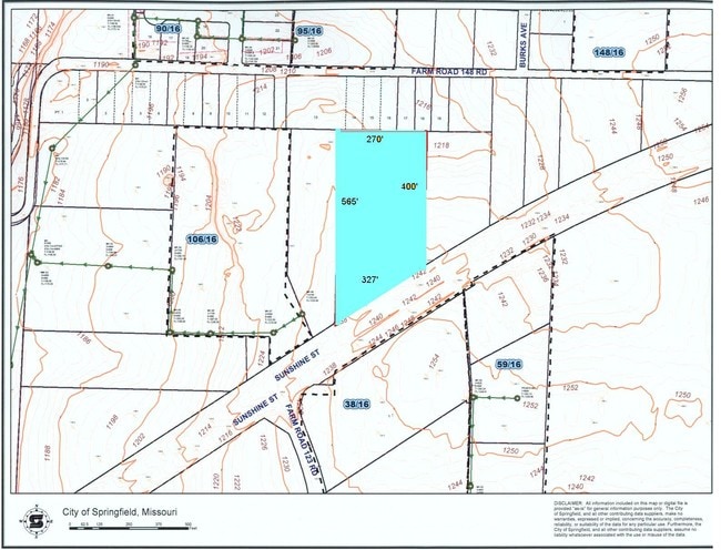
3961 W Sunshine St
13-32-200-038
3A BEG 706.67 FT W & 247.5 FT S NE COR NW1/4 W 271.4 FT S 671.2 FT TO CEN OFHWY NELY TO PT S OF BEG N TO BEG (EX HWY) 32/29/22
Commercialacreage
GREENE
C-2
Missouri
B and X Area of moderate flood hazard, usually the area between the limits of the 100-year and 500-year floods.
3 AC
2025
Northwest
2025
Springfield
004305
Springfield, MO
NEARBY LISTINGS FOR SALE OR LEASE
-
-
-
-
-
-
-
-
-
-
-
-
West Chestnut Expressway @ Chestnut Expressway and I-44
Springfield, MO 65802
Rent Upon Request
2.10 - 8.80 AC Lot
Land
-
-
-
-
-
-
-
-
View all Springfield listings for lease on LoopNet.com
DEMOGRAPHICS near 3961 W Sunshine St
1 mile
3 mile
5 mile
2025 Total Population
4,411
46,803
133,706
2030 Population
4,557
48,028
137,290
Pop Growth 2025-2030
+ 3.31%
+ 2.62%
+ 2.68%
Average Age
40
38
38
2025 Total Households
1,736
19,588
57,885
HH Growth 2025-2030
+ 3.40%
+ 2.82%
+ 2.87%
Median Household Inc
$75,403
$56,927
$52,579
Avg Household Size
2.50
2.30
2.20
2025 Avg HH Vehicles
2.00
2.00
2.00
Median Home Value
$236,299
$188,325
$196,982
Median Year Built
2000
1993
1985
Nearby Places
Map Layers
Map Styles
 Street
 Aerial
Layers
 Traffic
 Biking
Places
Listings with unknown addresses are not visible on the map
- Restaurants
- Banks
- Shops
- Fitness
- Groceries
PUBLIC TRANSPORTATION
AIRPORT
Springfield-Branson Ntl
Drive
Walk
Distance
Springfield-Branson Ntl
20 min
8.5 mi
Freight Ports
Tulsa Port of Inola
Drive
Walk
Distance
Tulsa Port of Inola
186 min
168.1 mi
Nearby Properties
Address
Land Use
TOTAL SIZE
Lot Size
Zoning
Address
Land Use
TOTAL SIZE
Lot Size
Zoning
320,532 SF
33.54 AC
INC
Address
Land Use
TOTAL SIZE
Lot Size
Zoning
22.64 AC
INC
Address
Land Use
TOTAL SIZE
Lot Size
Zoning
Address
Land Use
TOTAL SIZE
Lot Size
Zoning
312,092 SF
38 AC
INC
Address
Land Use
TOTAL SIZE
Lot Size
Zoning
614,588 SF
57.27 AC
INC
Address
Land Use
TOTAL SIZE
Lot Size
Zoning
129,652 SF
16.40 AC
INC
Address
Land Use
TOTAL SIZE
Lot Size
Zoning
334,594 SF
17.75 AC
INC
Address
Land Use
TOTAL SIZE
Lot Size
Zoning
253,781 SF
9.65 AC
INC
Address
Land Use
TOTAL SIZE
Lot Size
Zoning
159,007 SF
16.05 AC
INC
Address
Land Use
TOTAL SIZE
Lot Size
Zoning
65,208 SF
12.40 AC
INC
Address
Land Use
TOTAL SIZE
Lot Size
Zoning
12.81 AC
INC
Address
Land Use
TOTAL SIZE
Lot Size
Zoning
172,976 SF
5.99 AC
INC
Address
Land Use
TOTAL SIZE
Lot Size
Zoning
157,773 SF
18.55 AC
INC
Address
Land Use
TOTAL SIZE
Lot Size
Zoning
154,470 SF
16.97 AC
INC
Address
Land Use
TOTAL SIZE
Lot Size
Zoning
16.39 AC
INC
Address
Land Use
TOTAL SIZE
Lot Size
Zoning
20.54 AC
Address
Land Use
TOTAL SIZE
Lot Size
Zoning
Address
Land Use
TOTAL SIZE
Lot Size
Zoning
10.58 AC
INC
Address
Land Use
TOTAL SIZE
Lot Size
Zoning
47,500 SF
5.24 AC
INC
Address
Land Use
TOTAL SIZE
Lot Size
Zoning
44,000 SF
3.05 AC
INC
Address
Land Use
TOTAL SIZE
Lot Size
Zoning
20,211 SF
2.25 AC
INC.
Address
Land Use
TOTAL SIZE
Lot Size
Zoning
85,030 SF
8.89 AC
INC
Address
Land Use
TOTAL SIZE
Lot Size
Zoning
52,772 SF
5.12 AC
INC
Address
Land Use
TOTAL SIZE
Lot Size
Zoning
13.80 AC
C-2
Address
Land Use
TOTAL SIZE
Lot Size
Zoning
148,940 SF
10.08 AC
M-2
Address
Land Use
TOTAL SIZE
Lot Size
Zoning
57,485 SF
6.71 AC
INC
Address
Land Use
TOTAL SIZE
Lot Size
Zoning
271,752 SF
11.40 AC
INC
Address
Land Use
TOTAL SIZE
Lot Size
Zoning
6.90 AC
INC.
Address
Land Use
TOTAL SIZE
Lot Size
Zoning
115,000 SF
10.71 AC
INC
Address
Land Use
TOTAL SIZE
Lot Size
Zoning
11.87 AC
INC
The World's #1 Commercial Real Estate Marketplace
Connect with us
© 2026 CoStar Group
The information above has been obtained from sources believed reliable. While we do not doubt its accuracy we have not verified it and make no guarantee, warranty or representation about it. It is your responsibility to independently confirm its accuracy and completeness. Any projections, opinions, assumptions, or estimates used are for example only and do not represent the current or future performance of the property. The value of this transaction to you depends on tax and other factors which should be evaluated by your tax, financial, and legal advisors. You and your advisors should conduct a careful, independent investigation of the property to determine to your satisfaction the suitability of the property for your needs.