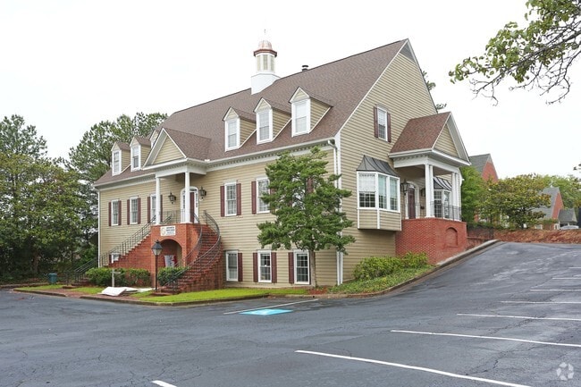
Property Record
4036 Wetherburn Way, Peachtree Corners, GA 30092

NEARBY LISTINGS FOR SALE OR LEASE
Property Detail
4036 Wetherburn Way
Atlanta-Sandy Springs-Roswell, GA
Fouts Corner
6-313-070
WETHERBURN WAY
Officebuilding
Gwinnett
X
Georgia
13089C0010K
2
2025
0.46 AC
2025
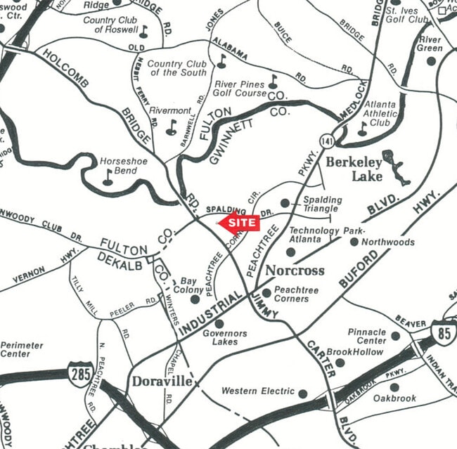
Norcross/Peachtree Corners
050335
Atlanta
7,600 SF
DEMOGRAPHICS near 4036 Wetherburn Way
1 Mile
3 Mile
5 Mile
2024 Total Population
9,534
72,435
202,109
2029 Population
9,865
74,291
205,992
Pop Growth 2024-2029
+ 3.47%
+ 2.56%
+ 1.92%
Average Age
40
39
39
2024 Total Households
3,942
28,529
76,095
HH Growth 2024-2029
+ 3.50%
+ 2.59%
+ 1.89%
Median Household Inc
$69,244
$86,556
$86,602
Avg Household Size
2.40
2.50
2.60
2024 Avg HH Vehicles
2.00
2.00
2.00
Median Home Value
$438,850
$466,098
$458,302
Median Year Built
1985
1986
1986
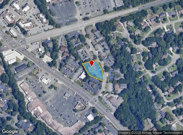
Nearby Places
Map Layers
Map Styles
 Street
 Aerial
- Restaurants
- Banks
- Shops
- Fitness
- Groceries
PUBLIC TRANSPORTATION
AIRPORT
Hartsfield - Jackson Atlanta International
DRIVE
WALK
Distance
Hartsfield - Jackson Atlanta International
45 min
31.7 mi
SALE & LEASE HISTORY
LISTING DATE
SALE/LEASE

Sep 23, 2016
For Sale
Jun 14, 2017
For Lease
Jun 06, 2017
For Sale
Jul 18, 2023
For Sale
Feb 14, 2018
For Lease
Feb 14, 2018
For Sale
Nearby Properties
Address
Land Use
TOTAL SIZE
Lot Size
Zoning
Address
Land Use
TOTAL SIZE
Lot Size
Zoning
599,105 SF
9.13 AC
M1
Address
Land Use
TOTAL SIZE
Lot Size
Zoning
524,000 SF
44.93 AC
RM
Address
Land Use
TOTAL SIZE
Lot Size
Zoning
545,074 SF
53.40 AC
RM8
Address
Land Use
TOTAL SIZE
Lot Size
Zoning
286,481 SF
20.06 AC
M1
Address
Land Use
TOTAL SIZE
Lot Size
Zoning
358,622 SF
31.01 AC
RM13
Address
Land Use
TOTAL SIZE
Lot Size
Zoning
231,192 SF
12.88 AC
RM13
Address
Land Use
TOTAL SIZE
Lot Size
Zoning
303,866 SF
20.13 AC
RM
Address
Land Use
TOTAL SIZE
Lot Size
Zoning
424,948 SF
39.03 AC
RM13
Address
Land Use
TOTAL SIZE
Lot Size
Zoning
1,196,908 SF
30.28 AC
OI
Address
Land Use
TOTAL SIZE
Lot Size
Zoning
1,423,656 SF
15.44 AC
OI
Address
Land Use
TOTAL SIZE
Lot Size
Zoning
426,839 SF
37.47 AC
MUD
Address
Land Use
TOTAL SIZE
Lot Size
Zoning
4,821,900 SF
20.58 AC
R4C
Address
Land Use
TOTAL SIZE
Lot Size
Zoning
250,886 SF
22.93 AC
RM13
Address
Land Use
TOTAL SIZE
Lot Size
Zoning
475,389 SF
5.37 AC
NX
Address
Land Use
TOTAL SIZE
Lot Size
Zoning
249,766 SF
25.34 AC
RM100
Address
Land Use
TOTAL SIZE
Lot Size
Zoning
220,150 SF
21.08 AC
RM13
Address
Land Use
TOTAL SIZE
Lot Size
Zoning
459,745 SF
50.72 AC
RM10
Address
Land Use
TOTAL SIZE
Lot Size
Zoning
420,576 SF
27.06 AC
M2
Address
Land Use
TOTAL SIZE
Lot Size
Zoning
6,769,095 SF
21.82 AC
OI
Address
Land Use
TOTAL SIZE
Lot Size
Zoning
291,110 SF
22.10 AC
X
Address
Land Use
TOTAL SIZE
Lot Size
Zoning
211,069 SF
14.91 AC
OI
Address
Land Use
TOTAL SIZE
Lot Size
Zoning
390,776 SF
43.96 AC
RM8
Address
Land Use
TOTAL SIZE
Lot Size
Zoning
225,314 SF
68.32 AC
OI
Address
Land Use
TOTAL SIZE
Lot Size
Zoning
205,850 SF
24.63 AC
RM10
Address
Land Use
TOTAL SIZE
Lot Size
Zoning
204,333 SF
39.43 AC
RM10
Address
Land Use
TOTAL SIZE
Lot Size
Zoning
336,694 SF
32.05 AC
RM10
Address
Land Use
TOTAL SIZE
Lot Size
Zoning
228,548 SF
16.50 AC
RM10
Address
Land Use
TOTAL SIZE
Lot Size
Zoning
419,868 SF
3.63 AC
MUD
Address
Land Use
TOTAL SIZE
Lot Size
Zoning
1,676,766 SF
23 AC
OIC
Address
Land Use
TOTAL SIZE
Lot Size
Zoning
2,849,264 SF
21 AC
OI
The World's #1 Commercial Real Estate Marketplace
Connect with us
© 2026 CoStar Group
The information above has been obtained from sources believed reliable. While we do not doubt its accuracy we have not verified it and make no guarantee, warranty or representation about it. It is your responsibility to independently confirm its accuracy and completeness. Any projections, opinions, assumptions, or estimates used are for example only and do not represent the current or future performance of the property. The value of this transaction to you depends on tax and other factors which should be evaluated by your tax, financial, and legal advisors. You and your advisors should conduct a careful, independent investigation of the property to determine to your satisfaction the suitability of the property for your needs.