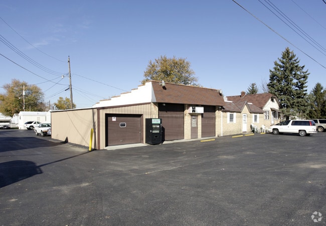
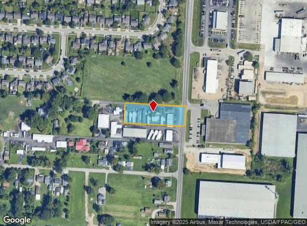
Property Record
4037 Lockbourne Rd, Columbus, OH 43207

NEARBY LISTINGS FOR SALE OR LEASE
Property Detail
4037 Lockbourne Rd
010-243368
Matthews Surv
Storebuilding
4037 LOCKBOURNE RD 1 ACRE R22 T4 S15
X
Franklin
39049C0338K
Ohio
2024
0.92 AC
2025
Southeast
008825
Columbus
2,330 SF
Columbus, OH
DEMOGRAPHICS near 4037 Lockbourne Rd
1 Mile
3 Mile
5 Mile
2024 Total Population
9,186
37,134
126,981
2029 Population
9,171
37,136
128,048
Pop Growth 2024-2029
(0.16%)
+ 0.01%
+ 0.84%
Average Age
39
40
39
2024 Total Households
3,271
14,148
51,871
HH Growth 2024-2029
(0.15%)
(0.04%)
+ 0.81%
Median Household Inc
$68,685
$58,547
$60,306
Avg Household Size
2.70
2.60
2.30
2024 Avg HH Vehicles
2.00
2.00
2.00
Median Home Value
$151,850
$152,685
$187,977
Median Year Built
1971
1970
1967
Nearby Places
Map Layers
Map Styles
 Street
 Aerial
- Restaurants
- Banks
- Shops
- Fitness
- Groceries
PUBLIC TRANSPORTATION
AIRPORT
Rickenbacker International
DRIVE
WALK
Distance
Rickenbacker International
14 min
6.5 mi
John Glenn Columbus International
DRIVE
WALK
Distance
John Glenn Columbus International
23 min
12.8 mi
Freight Ports
Port of Toledo
DRIVE
WALK
Distance
Port of Toledo
196 min
152.4 mi
Nearby Properties
Address
Land Use
TOTAL SIZE
Lot Size
Zoning
Address
Land Use
TOTAL SIZE
Lot Size
Zoning
1,172,656 SF
480.43 AC
Address
Land Use
TOTAL SIZE
Lot Size
Zoning
597,600 SF
68.91 AC
Address
Land Use
TOTAL SIZE
Lot Size
Zoning
1,054,500 SF
59.77 AC
Address
Land Use
TOTAL SIZE
Lot Size
Zoning
785,854 SF
30.85 AC
Address
Land Use
TOTAL SIZE
Lot Size
Zoning
130,865 SF
9.97 AC
Address
Land Use
TOTAL SIZE
Lot Size
Zoning
767,697 SF
39.49 AC
Address
Land Use
TOTAL SIZE
Lot Size
Zoning
655,288 SF
40.76 AC
Address
Land Use
TOTAL SIZE
Lot Size
Zoning
705,600 SF
43.41 AC
Address
Land Use
TOTAL SIZE
Lot Size
Zoning
737,054 SF
37.15 AC
Address
Land Use
TOTAL SIZE
Lot Size
Zoning
614,138 SF
36.90 AC
Address
Land Use
TOTAL SIZE
Lot Size
Zoning
642,331 SF
25.16 AC
Address
Land Use
TOTAL SIZE
Lot Size
Zoning
462,840 SF
27.07 AC
Address
Land Use
TOTAL SIZE
Lot Size
Zoning
107,676 SF
14.15 AC
Address
Land Use
TOTAL SIZE
Lot Size
Zoning
352,500 SF
20.75 AC
Address
Land Use
TOTAL SIZE
Lot Size
Zoning
516,025 SF
24.18 AC
Address
Land Use
TOTAL SIZE
Lot Size
Zoning
389,476 SF
18.84 AC
Address
Land Use
TOTAL SIZE
Lot Size
Zoning
406,364 SF
22.03 AC
Address
Land Use
TOTAL SIZE
Lot Size
Zoning
455,654 SF
24.55 AC
Address
Land Use
TOTAL SIZE
Lot Size
Zoning
311,190 SF
21.90 AC
Address
Land Use
TOTAL SIZE
Lot Size
Zoning
276,284 SF
14.77 AC
Address
Land Use
TOTAL SIZE
Lot Size
Zoning
257,400 SF
18.71 AC
Address
Land Use
TOTAL SIZE
Lot Size
Zoning
235,600 SF
11.25 AC
Address
Land Use
TOTAL SIZE
Lot Size
Zoning
604,078 SF
50.18 AC
Address
Land Use
TOTAL SIZE
Lot Size
Zoning
386,400 SF
21.24 AC
Address
Land Use
TOTAL SIZE
Lot Size
Zoning
111,874 SF
21.97 AC
Address
Land Use
TOTAL SIZE
Lot Size
Zoning
118,968 SF
13.09 AC
Address
Land Use
TOTAL SIZE
Lot Size
Zoning
196,580 SF
38.88 AC
Address
Land Use
TOTAL SIZE
Lot Size
Zoning
761,098 SF
35.07 AC
Address
Land Use
TOTAL SIZE
Lot Size
Zoning
253,764 SF
13.10 AC
Address
Land Use
TOTAL SIZE
Lot Size
Zoning
146,172 SF
26.42 AC
The World's #1 Commercial Real Estate Marketplace
Connect with us
© 2026 CoStar Group
The information above has been obtained from sources believed reliable. While we do not doubt its accuracy we have not verified it and make no guarantee, warranty or representation about it. It is your responsibility to independently confirm its accuracy and completeness. Any projections, opinions, assumptions, or estimates used are for example only and do not represent the current or future performance of the property. The value of this transaction to you depends on tax and other factors which should be evaluated by your tax, financial, and legal advisors. You and your advisors should conduct a careful, independent investigation of the property to determine to your satisfaction the suitability of the property for your needs.