Property Record
4037 N Oracle Rd, Tucson, AZ 85705
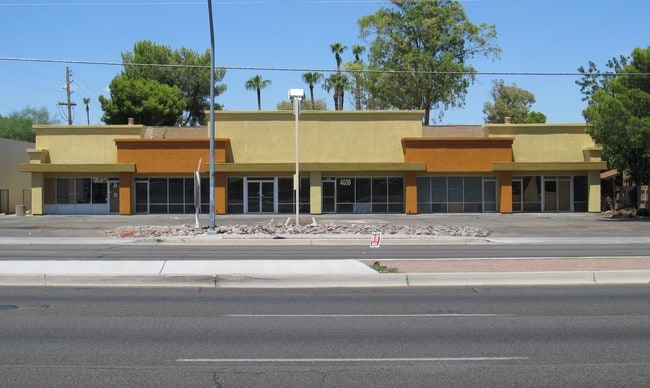


Property Detail
4037 N Oracle Rd
104-09-139A
S136 E205 TRACT 2 RESUB SE4 SE4 .64 AC SEC 23-13-13
Stripcommercialcenter
Pima
C3
Arizona
B and X Area of moderate flood hazard, usually the area between the limits of the 100-year and 500-year floods.
33
2025
0.64 AC
2026
Central West
004508
Tucson
7,680 SF
Tucson, AZ
NEARBY LISTINGS FOR SALE OR LEASE
DEMOGRAPHICS near 4037 N Oracle Rd
1 mile
3 mile
5 mile
2025 Total Population
14,634
107,212
237,541
2030 Population
15,010
110,856
244,475
Pop Growth 2025-2030
+ 2.57%
+ 3.40%
+ 2.92%
Average Age
39
39
39
2025 Total Households
6,894
49,654
107,070
HH Growth 2025-2030
+ 2.67%
+ 3.43%
+ 3.07%
Median Household Inc
$37,044
$44,678
$53,037
Avg Household Size
2.10
2.10
2.10
2025 Avg HH Vehicles
1.00
1.00
2.00
Median Home Value
$138,833
$244,432
$328,938
Median Year Built
1979
1980
1978
Nearby Places
Map Layers
Map Styles
 Street
 Aerial
Layers
 Traffic
 Biking
Places
Listings with unknown addresses are not visible on the map
- Restaurants
- Banks
- Shops
- Fitness
- Groceries
PUBLIC TRANSPORTATION
COMMUTER RAIL
Drive
Walk
Distance
10 min
4.5 mi
AIRPORT
Tucson International
Drive
Walk
Distance
Tucson International
24 min
13.1 mi
SALE & LEASE HISTORY
LISTING DATE
SALE/LEASE

Nov 09, 2022
For Sale
Nearby Properties
Address
Land Use
TOTAL SIZE
Lot Size
Zoning
Address
Land Use
TOTAL SIZE
Lot Size
Zoning
134,710 SF
9.59 AC
I1
Address
Land Use
TOTAL SIZE
Lot Size
Zoning
106,852 SF
19.50 AC
I1
Address
Land Use
TOTAL SIZE
Lot Size
Zoning
640,899 SF
13.61 AC
Address
Land Use
TOTAL SIZE
Lot Size
Zoning
451,596 SF
18.92 AC
C3
Address
Land Use
TOTAL SIZE
Lot Size
Zoning
39,508 SF
7.29 AC
MU
Address
Land Use
TOTAL SIZE
Lot Size
Zoning
145,357 SF
8.29 AC
C1
Address
Land Use
TOTAL SIZE
Lot Size
Zoning
251,043 SF
14.96 AC
Address
Land Use
TOTAL SIZE
Lot Size
Zoning
119,165 SF
21.85 AC
I1
Address
Land Use
TOTAL SIZE
Lot Size
Zoning
139,733 SF
9.80 AC
C3
Address
Land Use
TOTAL SIZE
Lot Size
Zoning
290,039 SF
1.98 AC
C3
Address
Land Use
TOTAL SIZE
Lot Size
Zoning
177,018 SF
16.78 AC
C2
Address
Land Use
TOTAL SIZE
Lot Size
Zoning
310,562 SF
16.89 AC
R3
Address
Land Use
TOTAL SIZE
Lot Size
Zoning
36,100 SF
2.42 AC
I1
Address
Land Use
TOTAL SIZE
Lot Size
Zoning
373,887 SF
28.70 AC
CR4
Address
Land Use
TOTAL SIZE
Lot Size
Zoning
312,586 SF
28.73 AC
Address
Land Use
TOTAL SIZE
Lot Size
Zoning
24,100 SF
4.96 AC
MU
Address
Land Use
TOTAL SIZE
Lot Size
Zoning
21,000 SF
9.34 AC
Address
Land Use
TOTAL SIZE
Lot Size
Zoning
209,967 SF
14.19 AC
Address
Land Use
TOTAL SIZE
Lot Size
Zoning
19,892 SF
3.36 AC
CB1
Address
Land Use
TOTAL SIZE
Lot Size
Zoning
239,446 SF
33 AC
R2
Address
Land Use
TOTAL SIZE
Lot Size
Zoning
68,107 SF
4.34 AC
Address
Land Use
TOTAL SIZE
Lot Size
Zoning
309,905 SF
13.09 AC
SP
Address
Land Use
TOTAL SIZE
Lot Size
Zoning
275,370 SF
18.03 AC
CR4
Address
Land Use
TOTAL SIZE
Lot Size
Zoning
324,571 SF
7.80 AC
C3
Address
Land Use
TOTAL SIZE
Lot Size
Zoning
4,712 SF
13.08 AC
Address
Land Use
TOTAL SIZE
Lot Size
Zoning
251,672 SF
13.88 AC
TR
Address
Land Use
TOTAL SIZE
Lot Size
Zoning
79,168 SF
3.98 AC
C3
Address
Land Use
TOTAL SIZE
Lot Size
Zoning
93,449 SF
7.04 AC
C3
Address
Land Use
TOTAL SIZE
Lot Size
Zoning
199,949 SF
20.27 AC
Address
Land Use
TOTAL SIZE
Lot Size
Zoning
116,116 SF
5.49 AC
The World's #1 Commercial Real Estate Marketplace
Connect with us
© 2026 CoStar Group
The information above has been obtained from sources believed reliable. While we do not doubt its accuracy we have not verified it and make no guarantee, warranty or representation about it. It is your responsibility to independently confirm its accuracy and completeness. Any projections, opinions, assumptions, or estimates used are for example only and do not represent the current or future performance of the property. The value of this transaction to you depends on tax and other factors which should be evaluated by your tax, financial, and legal advisors. You and your advisors should conduct a careful, independent investigation of the property to determine to your satisfaction the suitability of the property for your needs.