Property Record
4037 Salazar Way, Longmont, CO 80504
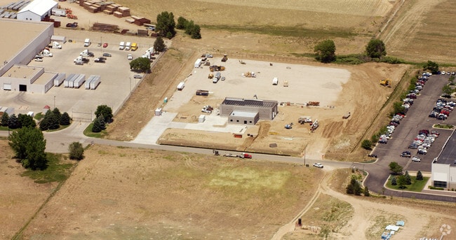

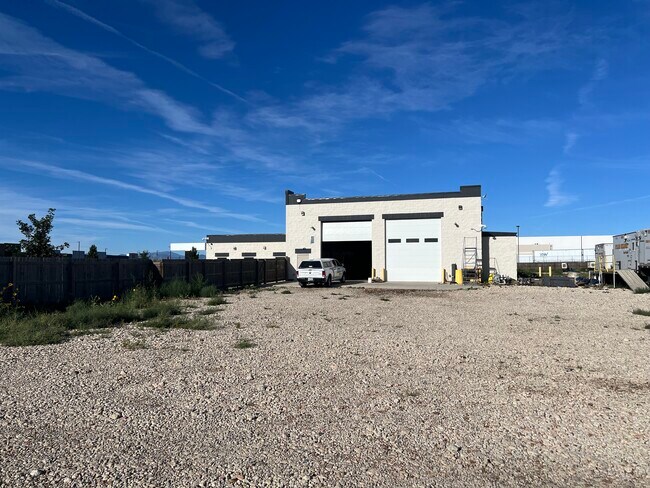
Property Detail
4037 Salazar Way
Greeley, CO
FRE DCSRA L4 DEL CAMINO SOUTH REPLAT OUTLOT A
R4238306
Weld
Warehouse
Colorado
B and X Area of moderate flood hazard, usually the area between the limits of the 100-year and 500-year floods.
4
2024
6.70 AC
2025
Weld County
002018
Denver
7,000 SF
NEARBY LISTINGS FOR SALE OR LEASE
-
-
-
-
-
NEC Tipple Parkway & I-25 Frontage Road East
Frederick, CO 80504
Rent Upon Request
189,280 SF
Industrial
-
-
NEC Tipple Parkway & I-25 Frontage Road East
Longmont, CO 80504
Rent Upon Request
74,880 SF
Industrial
-
NEC Tipple Parkway & I-25 Frontage Road East
Longmont, CO 80504
Rent Upon Request
212,160 SF
Industrial
-
NEC Tipple Parkway & I-25 Frontage Road East
Longmont, CO 80504
Rent Upon Request
148,720 SF
Industrial
-
NEC Tipple Parkway & I-25 Frontage Road East
Frederick, CO 80504
Rent Upon Request
109,200 SF
Industrial
-
-
-
-
-
View all Longmont listings for sale on LoopNet.com
DEMOGRAPHICS near 4037 Salazar Way
1 mile
3 mile
5 mile
2025 Total Population
1,130
27,392
53,302
2030 Population
1,259
30,023
58,512
Pop Growth 2025-2030
+ 11.42%
+ 9.60%
+ 9.77%
Average Age
39
37
38
2025 Total Households
355
9,052
18,506
HH Growth 2025-2030
+ 11.55%
+ 9.93%
+ 10.00%
Median Household Inc
$131,991
$125,595
$115,885
Avg Household Size
3.10
3.00
2.90
2025 Avg HH Vehicles
3.00
3.00
2.00
Median Home Value
$720,864
$631,749
$611,372
Median Year Built
2010
2007
2007
Nearby Places
Map Layers
Map Styles
 Street
 Aerial
Transit
 Traffic
 Biking
Places
Listings with unknown addresses are not visible on the map
- Restaurants
- Banks
- Shops
- Fitness
- Groceries
PUBLIC TRANSPORTATION
AIRPORT
Denver International
Drive
Walk
Distance
Denver International
42 min
35.7 mi
Freight Ports
Tulsa Port Of Catoosa
Drive
Walk
Distance
Tulsa Port Of Catoosa
749 min
729.9 mi
SALE & LEASE HISTORY
LISTING DATE
SALE/LEASE

Sep 19, 2024
For Sale
Nearby Properties
Address
Land Use
TOTAL SIZE
Lot Size
Zoning
Address
Land Use
TOTAL SIZE
Lot Size
Zoning
328,541 SF
19.97 AC
Address
Land Use
TOTAL SIZE
Lot Size
Zoning
207,946 SF
28.52 AC
Address
Land Use
TOTAL SIZE
Lot Size
Zoning
537,643 SF
40.16 AC
Address
Land Use
TOTAL SIZE
Lot Size
Zoning
123,729 SF
27 AC
Address
Land Use
TOTAL SIZE
Lot Size
Zoning
227,793 SF
12.47 AC
Address
Land Use
TOTAL SIZE
Lot Size
Zoning
429,053 SF
19.92 AC
Address
Land Use
TOTAL SIZE
Lot Size
Zoning
189,849 SF
13.10 AC
Address
Land Use
TOTAL SIZE
Lot Size
Zoning
47,531 SF
5.99 AC
Address
Land Use
TOTAL SIZE
Lot Size
Zoning
142,533 SF
16.51 AC
Address
Land Use
TOTAL SIZE
Lot Size
Zoning
69,399 SF
18.43 AC
Address
Land Use
TOTAL SIZE
Lot Size
Zoning
129,681 SF
12.96 AC
Address
Land Use
TOTAL SIZE
Lot Size
Zoning
73,074 SF
8.29 AC
Address
Land Use
TOTAL SIZE
Lot Size
Zoning
109,252 SF
8.70 AC
Address
Land Use
TOTAL SIZE
Lot Size
Zoning
92,749 SF
7.62 AC
Address
Land Use
TOTAL SIZE
Lot Size
Zoning
103,740 SF
11 AC
Address
Land Use
TOTAL SIZE
Lot Size
Zoning
40,980 SF
3.12 AC
Address
Land Use
TOTAL SIZE
Lot Size
Zoning
54,261 SF
7.50 AC
Address
Land Use
TOTAL SIZE
Lot Size
Zoning
107,268 SF
10.89 AC
Address
Land Use
TOTAL SIZE
Lot Size
Zoning
29,185 SF
6.67 AC
Address
Land Use
TOTAL SIZE
Lot Size
Zoning
87,231 SF
5.55 AC
Address
Land Use
TOTAL SIZE
Lot Size
Zoning
51,010 SF
14.66 AC
Address
Land Use
TOTAL SIZE
Lot Size
Zoning
48,515 SF
9.18 AC
Address
Land Use
TOTAL SIZE
Lot Size
Zoning
40,322 SF
5.07 AC
Address
Land Use
TOTAL SIZE
Lot Size
Zoning
41,870 SF
7.60 AC
Address
Land Use
TOTAL SIZE
Lot Size
Zoning
55,134 SF
4 AC
Address
Land Use
TOTAL SIZE
Lot Size
Zoning
95,150 SF
6.62 AC
Address
Land Use
TOTAL SIZE
Lot Size
Zoning
175,961 SF
7.41 AC
Address
Land Use
TOTAL SIZE
Lot Size
Zoning
47,438 SF
10 AC
Address
Land Use
TOTAL SIZE
Lot Size
Zoning
52,625 SF
3.73 AC
Address
Land Use
TOTAL SIZE
Lot Size
Zoning
83,796 SF
4.54 AC
The World's #1 Commercial Real Estate Marketplace
Connect with us
© 2026 CoStar Group
The information above has been obtained from sources believed reliable. While we do not doubt its accuracy we have not verified it and make no guarantee, warranty or representation about it. It is your responsibility to independently confirm its accuracy and completeness. Any projections, opinions, assumptions, or estimates used are for example only and do not represent the current or future performance of the property. The value of this transaction to you depends on tax and other factors which should be evaluated by your tax, financial, and legal advisors. You and your advisors should conduct a careful, independent investigation of the property to determine to your satisfaction the suitability of the property for your needs.