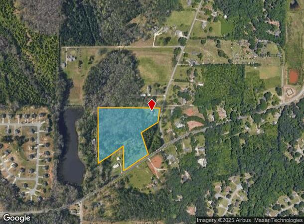
Property Record
4039 W Village Pkwy, Ellenwood, GA 30294

Current Lease Availabilities
NEARBY LISTINGS FOR SALE OR LEASE
-
-
View all Ellenwood listings for lease on LoopNet.com
Property Detail
4039 W Village Pkwy
Atlanta-Sandy Springs-Roswell, GA
Henry
0026-02-004-000
Georgia
Pud
10.29 AC
A
Outlying Henry County
13063C0082F
Atlanta
20,048 SF
DEMOGRAPHICS near 4039 W Village Pkwy
1 Mile
3 Mile
5 Mile
2024 Total Population
4,631
38,904
135,008
2029 Population
4,739
39,797
137,421
Pop Growth 2024-2029
+ 2.33%
+ 2.30%
+ 1.79%
Average Age
39
38
38
2024 Total Households
1,573
13,238
47,044
HH Growth 2024-2029
+ 2.42%
+ 2.36%
+ 1.86%
Median Household Inc
$69,022
$68,928
$62,578
Avg Household Size
2.90
2.90
2.80
2024 Avg HH Vehicles
2.00
2.00
2.00
Median Home Value
$189,341
$193,976
$191,461
Median Year Built
1999
1996
1993
Nearby Places
Map Layers
Map Styles
 Street
 Aerial
- Restaurants
- Banks
- Shops
- Fitness
- Groceries
PUBLIC TRANSPORTATION
AIRPORT
Hartsfield - Jackson Atlanta International
DRIVE
WALK
Distance
Hartsfield - Jackson Atlanta International
24 min
11.4 mi
Freight Ports
Georgia Ports - Savannah
DRIVE
WALK
Distance
Georgia Ports - Savannah
266 min
236.9 mi
Nearby Properties
Address
Land Use
TOTAL SIZE
Lot Size
Zoning
Address
Land Use
TOTAL SIZE
Lot Size
Zoning
797,738 SF
54.98 AC
WH
Address
Land Use
TOTAL SIZE
Lot Size
Zoning
659,547 SF
31.20 AC
HI
Address
Land Use
TOTAL SIZE
Lot Size
Zoning
332,442 SF
28.80 AC
HI
Address
Land Use
TOTAL SIZE
Lot Size
Zoning
229,829 SF
24.15 AC
HI
Address
Land Use
TOTAL SIZE
Lot Size
Zoning
343,585 SF
24.04 AC
LI
Address
Land Use
TOTAL SIZE
Lot Size
Zoning
142,742 SF
27.10 AC
RS110
Address
Land Use
TOTAL SIZE
Lot Size
Zoning
259,168 SF
29.08 AC
GB
Address
Land Use
TOTAL SIZE
Lot Size
Zoning
312,798 SF
21.38 AC
HI
Address
Land Use
TOTAL SIZE
Lot Size
Zoning
272,376 SF
17.73 AC
MXI
Address
Land Use
TOTAL SIZE
Lot Size
Zoning
399,000 SF
30.50 AC
WH
Address
Land Use
TOTAL SIZE
Lot Size
Zoning
400,000 SF
42.87 AC
HI
Address
Land Use
TOTAL SIZE
Lot Size
Zoning
210,670 SF
14.80 AC
HI
Address
Land Use
TOTAL SIZE
Lot Size
Zoning
271,919 SF
17.89 AC
HI
Address
Land Use
TOTAL SIZE
Lot Size
Zoning
214,055 SF
55.08 AC
HI
Address
Land Use
TOTAL SIZE
Lot Size
Zoning
188,589 SF
27.76 AC
PUD
Address
Land Use
TOTAL SIZE
Lot Size
Zoning
23,169 SF
21.09 AC
PUD
Address
Land Use
TOTAL SIZE
Lot Size
Zoning
95,132 SF
20.76 AC
AG
Address
Land Use
TOTAL SIZE
Lot Size
Zoning
127,735 SF
20.74 AC
M1
Address
Land Use
TOTAL SIZE
Lot Size
Zoning
110,621 SF
20.57 AC
HI
Address
Land Use
TOTAL SIZE
Lot Size
Zoning
49,528 SF
32.24 AC
GZ
Address
Land Use
TOTAL SIZE
Lot Size
Zoning
14,240 SF
48.13 AC
HI
Address
Land Use
TOTAL SIZE
Lot Size
Zoning
120,015 SF
26 AC
RS110
Address
Land Use
TOTAL SIZE
Lot Size
Zoning
6,425 SF
64.33 AC
HI
Address
Land Use
TOTAL SIZE
Lot Size
Zoning
5,475 SF
37.07 AC
HI
Address
Land Use
TOTAL SIZE
Lot Size
Zoning
2,380 SF
41.50 AC
RS180
Address
Land Use
TOTAL SIZE
Lot Size
Zoning
234,192 SF
23 AC
HI
Address
Land Use
TOTAL SIZE
Lot Size
Zoning
68,418 SF
15.10 AC
RS110
Address
Land Use
TOTAL SIZE
Lot Size
Zoning
80,431 SF
9.53 AC
C2
Address
Land Use
TOTAL SIZE
Lot Size
Zoning
101,848 SF
19.95 AC
C1
Address
Land Use
TOTAL SIZE
Lot Size
Zoning
5,320 SF
1,148.42 AC
X
The World's #1 Commercial Real Estate Marketplace
Connect with us
© 2026 CoStar Group
The information above has been obtained from sources believed reliable. While we do not doubt its accuracy we have not verified it and make no guarantee, warranty or representation about it. It is your responsibility to independently confirm its accuracy and completeness. Any projections, opinions, assumptions, or estimates used are for example only and do not represent the current or future performance of the property. The value of this transaction to you depends on tax and other factors which should be evaluated by your tax, financial, and legal advisors. You and your advisors should conduct a careful, independent investigation of the property to determine to your satisfaction the suitability of the property for your needs.