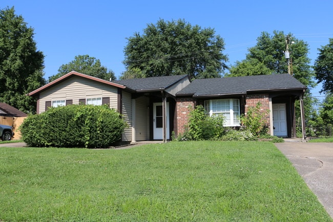
Property Record
4039 Rudy Martin Dr, Owensboro, KY 42301
NEARBY LISTINGS FOR SALE OR LEASE
-
-
View all Owensboro listings for sale on LoopNet.com
Property Detail
4039 Rudy Martin Dr
004-24-06-007-00-000
Carriage Park
Commercialnec
4-24-2-144032 RUDY MARTIN DR60 X 100
AE
Daviess
21059C0257E
Kentucky
2025
0.15 AC
2025
Other Market Areas
001701
Owensboro, KY
1,474 SF
DEMOGRAPHICS near 4039 Rudy Martin Dr
1 Mile
3 Mile
5 Mile
2024 Total Population
5,682
36,325
66,535
2029 Population
5,576
36,388
66,663
Pop Growth 2024-2029
(1.87%)
+ 0.17%
+ 0.19%
Average Age
37
41
40
2024 Total Households
2,355
15,534
27,621
HH Growth 2024-2029
(1.87%)
+ 0.21%
+ 0.22%
Median Household Inc
$59,484
$53,633
$53,109
Avg Household Size
2.40
2.20
2.30
2024 Avg HH Vehicles
2.00
2.00
2.00
Median Home Value
$151,367
$149,205
$153,534
Median Year Built
1979
1968
1972
Nearby Places
Map Layers
Map Styles
 Street
 Aerial
- Restaurants
- Banks
- Shops
- Fitness
- Groceries
PUBLIC TRANSPORTATION
AIRPORT
Evansville Regional
DRIVE
WALK
Distance
Evansville Regional
59 min
42.0 mi
Freight Ports
Port of Toledo
DRIVE
WALK
Distance
Port of Toledo
479 min
417.2 mi
SALE & LEASE HISTORY
LISTING DATE
SALE/LEASE

Aug 14, 2019
For Sale
Nearby Properties
Address
Land Use
TOTAL SIZE
Lot Size
Zoning
Address
Land Use
TOTAL SIZE
Lot Size
Zoning
184,854 SF
9.46 AC
Address
Land Use
TOTAL SIZE
Lot Size
Zoning
198,394 SF
49.52 AC
Address
Land Use
TOTAL SIZE
Lot Size
Zoning
371,705 SF
57.02 AC
Address
Land Use
TOTAL SIZE
Lot Size
Zoning
424,078 SF
43.02 AC
Address
Land Use
TOTAL SIZE
Lot Size
Zoning
187,364 SF
18.64 AC
Address
Land Use
TOTAL SIZE
Lot Size
Zoning
29,600 SF
3.38 AC
Address
Land Use
TOTAL SIZE
Lot Size
Zoning
165,207 SF
15.76 AC
Address
Land Use
TOTAL SIZE
Lot Size
Zoning
215,439 SF
15.02 AC
Address
Land Use
TOTAL SIZE
Lot Size
Zoning
53,280 SF
Address
Land Use
TOTAL SIZE
Lot Size
Zoning
326,232 SF
29.64 AC
Address
Land Use
TOTAL SIZE
Lot Size
Zoning
54,713 SF
20 AC
Address
Land Use
TOTAL SIZE
Lot Size
Zoning
45,860 SF
13.88 AC
Address
Land Use
TOTAL SIZE
Lot Size
Zoning
69,884 SF
61.31 AC
Address
Land Use
TOTAL SIZE
Lot Size
Zoning
122,450 SF
7.63 AC
Address
Land Use
TOTAL SIZE
Lot Size
Zoning
193,067 SF
19.80 AC
Address
Land Use
TOTAL SIZE
Lot Size
Zoning
155,700 SF
7.78 AC
Address
Land Use
TOTAL SIZE
Lot Size
Zoning
85,349 SF
9.23 AC
Address
Land Use
TOTAL SIZE
Lot Size
Zoning
82,396 SF
28.50 AC
Address
Land Use
TOTAL SIZE
Lot Size
Zoning
4.35 AC
Address
Land Use
TOTAL SIZE
Lot Size
Zoning
24.58 AC
Address
Land Use
TOTAL SIZE
Lot Size
Zoning
212,423 SF
Address
Land Use
TOTAL SIZE
Lot Size
Zoning
17,289 SF
810.94 AC
Address
Land Use
TOTAL SIZE
Lot Size
Zoning
116,601 SF
15.72 AC
Address
Land Use
TOTAL SIZE
Lot Size
Zoning
44,887 SF
4.31 AC
Address
Land Use
TOTAL SIZE
Lot Size
Zoning
125,000 SF
20.10 AC
Address
Land Use
TOTAL SIZE
Lot Size
Zoning
46,844 SF
2.72 AC
Address
Land Use
TOTAL SIZE
Lot Size
Zoning
135,855 SF
18.24 AC
Address
Land Use
TOTAL SIZE
Lot Size
Zoning
63,050 SF
6.91 AC
Address
Land Use
TOTAL SIZE
Lot Size
Zoning
87,184 SF
8.62 AC
Address
Land Use
TOTAL SIZE
Lot Size
Zoning
25,087 SF
22.57 AC
The World's #1 Commercial Real Estate Marketplace
Connect with us
© 2025 CoStar Group
The information above has been obtained from sources believed reliable. While we do not doubt its accuracy we have not verified it and make no guarantee, warranty or representation about it. It is your responsibility to independently confirm its accuracy and completeness. Any projections, opinions, assumptions, or estimates used are for example only and do not represent the current or future performance of the property. The value of this transaction to you depends on tax and other factors which should be evaluated by your tax, financial, and legal advisors. You and your advisors should conduct a careful, independent investigation of the property to determine to your satisfaction the suitability of the property for your needs.