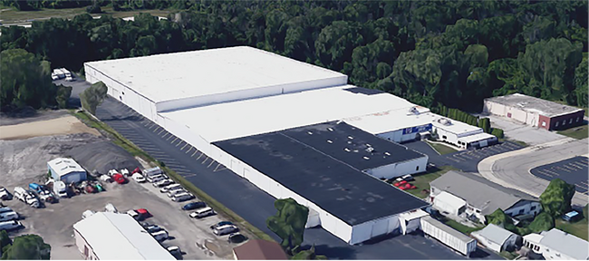
Property Record
404 41St St, Bay City, MI 48708

Current Lease Availabilities
Property Detail
404 41St St
09-130-005-200-030-00
COM 93.89 FT WLY ALG SLY LI OF MCGRAW ST FR E LI SEC 5 TH S 696.5 FT TH W 349.23 FT TH N 508.66 FT TH E 211.73 FT TH N M/L 242.06 FT TO SLY LI OF MCGRAW ST TH SELY 148.11 FT TO BEG. SEC 5 T13N R5E
Industrialgeneral
BAY
AE The base floodplain where base flood elevations are provided. AE Zones are now used on new format FIRMs instead of A1-A30 Zones.
Michigan
2025
4.76 AC
2025
Midland/Flint
280600
Other Market Areas
162,182 SF
Bay City, MI
NEARBY LISTINGS FOR SALE OR LEASE
DEMOGRAPHICS near 404 41St St
1 mile
3 mile
5 mile
2025 Total Population
3,868
29,560
59,576
2030 Population
3,845
29,441
59,234
Pop Growth 2025-2030
(0.59%)
(0.40%)
(0.57%)
Average Age
41
43
43
2025 Total Households
1,616
12,988
26,424
HH Growth 2025-2030
(0.56%)
(0.45%)
(0.55%)
Median Household Inc
$53,988
$51,317
$53,986
Avg Household Size
2.30
2.20
2.20
2025 Avg HH Vehicles
2.00
2.00
2.00
Median Home Value
$98,905
$127,129
$138,360
Median Year Built
1949
1949
1954
Nearby Places
Map Layers
Map Styles
 Street
 Aerial
Layers
 Traffic
 Biking
Places
Listings with unknown addresses are not visible on the map
- Restaurants
- Banks
- Shops
- Fitness
- Groceries
PUBLIC TRANSPORTATION
AIRPORT
MBS International
Drive
Walk
Distance
MBS International
27 min
17.4 mi
Freight Ports
Port of Toledo
Drive
Walk
Distance
Port of Toledo
179 min
153.7 mi
Nearby Properties
Address
Land Use
TOTAL SIZE
Lot Size
Zoning
Address
Land Use
TOTAL SIZE
Lot Size
Zoning
97,304 SF
3.61 AC
C-3 CTRL B
Address
Land Use
TOTAL SIZE
Lot Size
Zoning
279,395 SF
192 AC
I-2
Address
Land Use
TOTAL SIZE
Lot Size
Zoning
60,200 SF
9.50 AC
C-3 CTRL B
Address
Land Use
TOTAL SIZE
Lot Size
Zoning
1.87 AC
C-3 CTRL B
Address
Land Use
TOTAL SIZE
Lot Size
Zoning
57,000 SF
1.09 AC
C-3 CTRL B
Address
Land Use
TOTAL SIZE
Lot Size
Zoning
15.15 AC
M-1 LT IND
Address
Land Use
TOTAL SIZE
Lot Size
Zoning
50,965 SF
0.83 AC
C-3 CTRL B
Address
Land Use
TOTAL SIZE
Lot Size
Zoning
22,356 SF
I-2
Address
Land Use
TOTAL SIZE
Lot Size
Zoning
39,417 SF
0.23 AC
C-3 CTRL B
Address
Land Use
TOTAL SIZE
Lot Size
Zoning
63,200 SF
1.97 AC
C-3 CTRL B
Address
Land Use
TOTAL SIZE
Lot Size
Zoning
C-3 CTRL B
Address
Land Use
TOTAL SIZE
Lot Size
Zoning
7,200 SF
0.69 AC
C-3 CTRL B
Address
Land Use
TOTAL SIZE
Lot Size
Zoning
139,237 SF
5.47 AC
C-3 CTRL B
Address
Land Use
TOTAL SIZE
Lot Size
Zoning
M-1 LT IND
Address
Land Use
TOTAL SIZE
Lot Size
Zoning
Address
Land Use
TOTAL SIZE
Lot Size
Zoning
1.91 AC
Address
Land Use
TOTAL SIZE
Lot Size
Zoning
11,630 SF
2.26 AC
C-2
Address
Land Use
TOTAL SIZE
Lot Size
Zoning
0.26 AC
C-3 CTRL B
Address
Land Use
TOTAL SIZE
Lot Size
Zoning
3,087 SF
21.78 AC
RMH RES MO
Address
Land Use
TOTAL SIZE
Lot Size
Zoning
6,906 SF
0.03 AC
C-3 CTRL B
Address
Land Use
TOTAL SIZE
Lot Size
Zoning
0.24 AC
C-3 CTRL B
Address
Land Use
TOTAL SIZE
Lot Size
Zoning
76,027 SF
9.13 AC
C-2B HWY B
Address
Land Use
TOTAL SIZE
Lot Size
Zoning
47,100 SF
7.54 AC
C-2B HWY B
Address
Land Use
TOTAL SIZE
Lot Size
Zoning
161,292 SF
11.16 AC
M-1 LT IND
Address
Land Use
TOTAL SIZE
Lot Size
Zoning
6,906 SF
0.03 AC
C-3 CTRL B
Address
Land Use
TOTAL SIZE
Lot Size
Zoning
1.47 AC
Address
Land Use
TOTAL SIZE
Lot Size
Zoning
13,833 SF
1.34 AC
C-2
Address
Land Use
TOTAL SIZE
Lot Size
Zoning
225,840 SF
17.02 AC
WF WATERFR
Address
Land Use
TOTAL SIZE
Lot Size
Zoning
75,000 SF
0.57 AC
C-3 CTRL B
The World's #1 Commercial Real Estate Marketplace
Connect with us
© 2026 CoStar Group
The information above has been obtained from sources believed reliable. While we do not doubt its accuracy we have not verified it and make no guarantee, warranty or representation about it. It is your responsibility to independently confirm its accuracy and completeness. Any projections, opinions, assumptions, or estimates used are for example only and do not represent the current or future performance of the property. The value of this transaction to you depends on tax and other factors which should be evaluated by your tax, financial, and legal advisors. You and your advisors should conduct a careful, independent investigation of the property to determine to your satisfaction the suitability of the property for your needs.