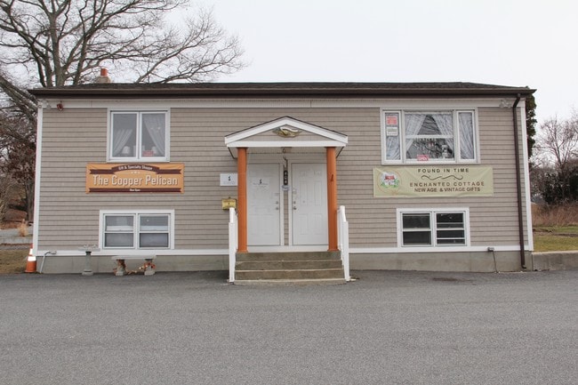
Property Record
404 Main Rd, Tiverton, RI 02878
NEARBY LISTINGS FOR SALE OR LEASE
Property Detail
404 Main Rd
Commercialofficeresidentialmixeduse
Newport
X
Rhode Island
25005C0337G
0.20 AC
2025
Newport County
2025
Providence
041601
Providence-Warwick, RI-MA
1,120 SF
TIVE-000113-000000-000498
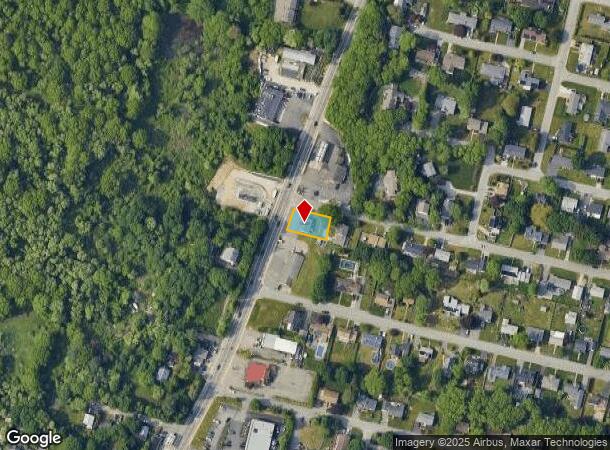
DEMOGRAPHICS near 404 Main Rd
1 Mile
3 Mile
5 Mile
2024 Total Population
6,201
56,332
134,429
2029 Population
6,018
55,587
133,179
Pop Growth 2024-2029
(2.95%)
(1.32%)
(0.93%)
Average Age
45
41
41
2024 Total Households
2,745
24,215
57,452
HH Growth 2024-2029
(3.17%)
(1.40%)
(0.96%)
Median Household Inc
$73,198
$53,005
$58,676
Avg Household Size
2.20
2.30
2.20
2024 Avg HH Vehicles
2.00
1.00
2.00
Median Home Value
$320,158
$352,988
$362,411
Median Year Built
1954
1948
1950
Nearby Places
Map Layers
Map Styles
 Street
 Aerial
- Restaurants
- Banks
- Shops
- Fitness
- Groceries
PUBLIC TRANSPORTATION
AIRPORT
Rhode Island Tf Green International
DRIVE
WALK
Distance
Rhode Island Tf Green International
40 min
26.9 mi
Freight Ports
Port of Davisville, RI
DRIVE
WALK
Distance
Port of Davisville, RI
55 min
30.4 mi
SALE & LEASE HISTORY
LISTING DATE
SALE/LEASE

Oct 31, 2017
For Sale
May 30, 2017
For Sale
May 05, 2017
For Sale
Nearby Properties
Address
Land Use
TOTAL SIZE
Lot Size
Zoning
Address
Land Use
TOTAL SIZE
Lot Size
Zoning
11.26 AC
IND
Address
Land Use
TOTAL SIZE
Lot Size
Zoning
27.66 AC
I
Address
Land Use
TOTAL SIZE
Lot Size
Zoning
73,957 SF
46.62 AC
CO
Address
Land Use
TOTAL SIZE
Lot Size
Zoning
183,732 SF
5.50 AC
IND
Address
Land Use
TOTAL SIZE
Lot Size
Zoning
6.16 AC
B-L
Address
Land Use
TOTAL SIZE
Lot Size
Zoning
132,666 SF
18.97 AC
IND
Address
Land Use
TOTAL SIZE
Lot Size
Zoning
16.08 AC
N/A
Address
Land Use
TOTAL SIZE
Lot Size
Zoning
107,441 SF
2.10 AC
N/A
Address
Land Use
TOTAL SIZE
Lot Size
Zoning
113,643 SF
4.95 AC
R-4
Address
Land Use
TOTAL SIZE
Lot Size
Zoning
559.70 AC
S
Address
Land Use
TOTAL SIZE
Lot Size
Zoning
116,036 SF
2.43 AC
R-4
Address
Land Use
TOTAL SIZE
Lot Size
Zoning
78,883 SF
40.99 AC
N/A
Address
Land Use
TOTAL SIZE
Lot Size
Zoning
150,156 SF
8.77 AC
R40
Address
Land Use
TOTAL SIZE
Lot Size
Zoning
9.44 AC
A-2
Address
Land Use
TOTAL SIZE
Lot Size
Zoning
177,051 SF
3.13 AC
CBD
Address
Land Use
TOTAL SIZE
Lot Size
Zoning
194,181 SF
3.40 AC
Address
Land Use
TOTAL SIZE
Lot Size
Zoning
124,038 SF
74.50 AC
R60
Address
Land Use
TOTAL SIZE
Lot Size
Zoning
178,538 SF
17.27 AC
I
Address
Land Use
TOTAL SIZE
Lot Size
Zoning
75,736 SF
1.39 AC
B-L
Address
Land Use
TOTAL SIZE
Lot Size
Zoning
22.36 AC
B-N
Address
Land Use
TOTAL SIZE
Lot Size
Zoning
99,066 SF
3.05 AC
IND
Address
Land Use
TOTAL SIZE
Lot Size
Zoning
144,773 SF
10.50 AC
R60
Address
Land Use
TOTAL SIZE
Lot Size
Zoning
8.83 AC
R-8
Address
Land Use
TOTAL SIZE
Lot Size
Zoning
79,708 SF
0.76 AC
IND
Address
Land Use
TOTAL SIZE
Lot Size
Zoning
3.55 AC
N/A
Address
Land Use
TOTAL SIZE
Lot Size
Zoning
9,288 SF
113.04 AC
R60
Address
Land Use
TOTAL SIZE
Lot Size
Zoning
10 AC
HC
Address
Land Use
TOTAL SIZE
Lot Size
Zoning
44.10 AC
R-40
Address
Land Use
TOTAL SIZE
Lot Size
Zoning
84,000 SF
3.31 AC
I
Address
Land Use
TOTAL SIZE
Lot Size
Zoning
80,278 SF
1.12 AC
A-2
The World's #1 Commercial Real Estate Marketplace
Connect with us
© 2026 CoStar Group
The information above has been obtained from sources believed reliable. While we do not doubt its accuracy we have not verified it and make no guarantee, warranty or representation about it. It is your responsibility to independently confirm its accuracy and completeness. Any projections, opinions, assumptions, or estimates used are for example only and do not represent the current or future performance of the property. The value of this transaction to you depends on tax and other factors which should be evaluated by your tax, financial, and legal advisors. You and your advisors should conduct a careful, independent investigation of the property to determine to your satisfaction the suitability of the property for your needs.