Property Record
4040 Bell St, Fort Myers, FL 33916


This Property Is For Sale
NEARBY LISTINGS FOR SALE OR LEASE
Property Detail
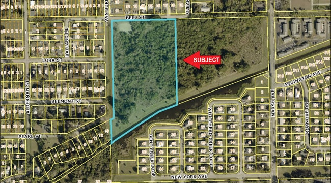
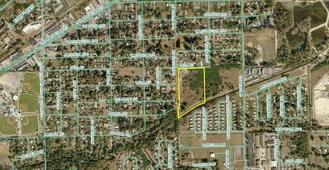
4040 Bell St
Cape Coral-Fort Myers, FL
Palmetto To Prospect. Creek
08-44-25-P3-00068.0010
BEG AT WLY LINE MARSH AVE + SLY LINE BELL ST THENCE W 751.63 FT TO POB + POR OF VAC ALLEY OR 2037/573
Residentialacreage
Lee
AE
Florida
12071C0287G
1
2024
9.68 AC
2025
City of Ft Myers
000600
Southwest Florida
DEMOGRAPHICS near 4040 Bell St
1 Mile
3 Mile
5 Mile
2024 Total Population
11,863
47,519
119,622
2029 Population
13,985
56,355
142,498
Pop Growth 2024-2029
+ 17.89%
+ 18.59%
+ 19.12%
Average Age
33
40
43
2024 Total Households
3,758
17,696
49,492
HH Growth 2024-2029
+ 17.54%
+ 18.51%
+ 18.96%
Median Household Inc
$36,390
$42,184
$47,753
Avg Household Size
2.90
2.40
2.20
2024 Avg HH Vehicles
1.00
1.00
1.00
Median Home Value
$111,246
$162,001
$213,477
Median Year Built
1975
1981
1988
Nearby Places
Map Layers
Map Styles
 Street
 Aerial
- Restaurants
- Banks
- Shops
- Fitness
- Groceries
PUBLIC TRANSPORTATION
AIRPORT
Southwest Florida International
DRIVE
WALK
Distance
Southwest Florida International
23 min
12.9 mi
Punta Gorda
DRIVE
WALK
Distance
Punta Gorda
34 min
25.1 mi
Nearby Properties
Address
Land Use
TOTAL SIZE
Lot Size
Zoning
Address
Land Use
TOTAL SIZE
Lot Size
Zoning
770,753 SF
5.87 AC
PUD
Address
Land Use
TOTAL SIZE
Lot Size
Zoning
77.79 AC
PUD
Address
Land Use
TOTAL SIZE
Lot Size
Zoning
4.48 AC
U-CTR
Address
Land Use
TOTAL SIZE
Lot Size
Zoning
438,839 SF
66.95 AC
MU
Address
Land Use
TOTAL SIZE
Lot Size
Zoning
475,045 SF
30.22 AC
PUD
Address
Land Use
TOTAL SIZE
Lot Size
Zoning
723,322 SF
1.73 AC
PUD
Address
Land Use
TOTAL SIZE
Lot Size
Zoning
286,629 SF
13.01 AC
SDA
Address
Land Use
TOTAL SIZE
Lot Size
Zoning
98,242 SF
17.43 AC
RS-7
Address
Land Use
TOTAL SIZE
Lot Size
Zoning
694,188 SF
22.43 AC
PUD
Address
Land Use
TOTAL SIZE
Lot Size
Zoning
580,121 SF
61.83 AC
IL
Address
Land Use
TOTAL SIZE
Lot Size
Zoning
243,841 SF
3.17 AC
CIVIC
Address
Land Use
TOTAL SIZE
Lot Size
Zoning
376,949 SF
49.70 AC
RM16
Address
Land Use
TOTAL SIZE
Lot Size
Zoning
6.99 AC
C-1
Address
Land Use
TOTAL SIZE
Lot Size
Zoning
163,618 SF
1.32 AC
CIVIC
Address
Land Use
TOTAL SIZE
Lot Size
Zoning
551,003 SF
3.24 AC
PUD
Address
Land Use
TOTAL SIZE
Lot Size
Zoning
319,765 SF
47.40 AC
RS7
Address
Land Use
TOTAL SIZE
Lot Size
Zoning
107,306 SF
1.91 AC
CIVIC
Address
Land Use
TOTAL SIZE
Lot Size
Zoning
6.38 AC
SDA
Address
Land Use
TOTAL SIZE
Lot Size
Zoning
67.46 AC
C1
Address
Land Use
TOTAL SIZE
Lot Size
Zoning
305,410 SF
1.38 AC
U-CTR
Address
Land Use
TOTAL SIZE
Lot Size
Zoning
106,300 SF
14.71 AC
TFC2
Address
Land Use
TOTAL SIZE
Lot Size
Zoning
231,360 SF
17.08 AC
PUD
Address
Land Use
TOTAL SIZE
Lot Size
Zoning
11,062 SF
47.11 AC
Address
Land Use
TOTAL SIZE
Lot Size
Zoning
76,154 SF
2.88 AC
U-CTR
Address
Land Use
TOTAL SIZE
Lot Size
Zoning
115,004 SF
1.91 AC
CIVIC
Address
Land Use
TOTAL SIZE
Lot Size
Zoning
291,613 SF
40.32 AC
RPD
Address
Land Use
TOTAL SIZE
Lot Size
Zoning
93,758 SF
1.72 AC
CIVIC
Address
Land Use
TOTAL SIZE
Lot Size
Zoning
182,503 SF
1.34 AC
CIVIC
Address
Land Use
TOTAL SIZE
Lot Size
Zoning
137,687 SF
18.25 AC
RS7
Address
Land Use
TOTAL SIZE
Lot Size
Zoning
88,345 SF
13.59 AC
C-1
The World's #1 Commercial Real Estate Marketplace
Connect with us
© 2026 CoStar Group
The information above has been obtained from sources believed reliable. While we do not doubt its accuracy we have not verified it and make no guarantee, warranty or representation about it. It is your responsibility to independently confirm its accuracy and completeness. Any projections, opinions, assumptions, or estimates used are for example only and do not represent the current or future performance of the property. The value of this transaction to you depends on tax and other factors which should be evaluated by your tax, financial, and legal advisors. You and your advisors should conduct a careful, independent investigation of the property to determine to your satisfaction the suitability of the property for your needs.