Property Record
4040 Highway 59, Covington, LA 70433
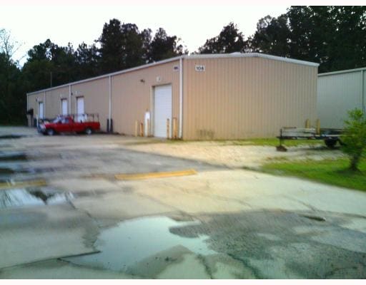

Property Detail
4040 Highway 59
Slidell-Mandeville-Covington, LA
LOT 6 CONT 44,905 SQ FT SEC 25 7 11 CAMPBELL BUISNESS PARK CB 705 731 CB 723 398 402 CB 836 644 645 INST NO 1134181 INST NO 1
39129
ST TAMMANY
Commercialnec
Louisiana
2025
6
2025
1 AC
040602
Mandeville/Covington
16,850 SF
New Orleans/Metairie/Kenner
NEARBY LISTINGS FOR SALE OR LEASE
DEMOGRAPHICS near 4040 Highway 59
1 mile
3 mile
5 mile
2025 Total Population
2,080
31,811
71,169
2030 Population
2,154
32,484
72,951
Pop Growth 2025-2030
+ 3.56%
+ 2.12%
+ 2.50%
Average Age
39
40
41
2025 Total Households
736
11,761
27,754
HH Growth 2025-2030
+ 3.67%
+ 2.20%
+ 2.57%
Median Household Inc
$107,246
$95,382
$88,605
Avg Household Size
2.80
2.70
2.50
2025 Avg HH Vehicles
2.00
2.00
2.00
Median Home Value
$393,547
$345,726
$343,006
Median Year Built
2000
1996
1995
Nearby Places
Map Layers
Map Styles
 Street
 Aerial
Transit
 Traffic
 Biking
Places
Listings with unknown addresses are not visible on the map
- Restaurants
- Banks
- Shops
- Fitness
- Groceries
PUBLIC TRANSPORTATION
AIRPORT
Louis Armstrong New Orleans International
Drive
Walk
Distance
Louis Armstrong New Orleans International
55 min
41.7 mi
Freight Ports
Port of New Orleans
Drive
Walk
Distance
Port of New Orleans
59 min
42.7 mi
Nearby Properties
Address
Land Use
TOTAL SIZE
Lot Size
Zoning
Address
Land Use
TOTAL SIZE
Lot Size
Zoning
Address
Land Use
TOTAL SIZE
Lot Size
Zoning
Address
Land Use
TOTAL SIZE
Lot Size
Zoning
178,608 SF
34.02 AC
Address
Land Use
TOTAL SIZE
Lot Size
Zoning
266,213 SF
40 AC
Address
Land Use
TOTAL SIZE
Lot Size
Zoning
154,751 SF
14.96 AC
Address
Land Use
TOTAL SIZE
Lot Size
Zoning
68,478 SF
6.64 AC
Address
Land Use
TOTAL SIZE
Lot Size
Zoning
156,183 SF
20 AC
Address
Land Use
TOTAL SIZE
Lot Size
Zoning
57,360 SF
2.77 AC
Address
Land Use
TOTAL SIZE
Lot Size
Zoning
147,457 SF
8.90 AC
Address
Land Use
TOTAL SIZE
Lot Size
Zoning
131,925 SF
2.02 AC
Address
Land Use
TOTAL SIZE
Lot Size
Zoning
2,053 SF
2 AC
Address
Land Use
TOTAL SIZE
Lot Size
Zoning
119,501 SF
20.38 AC
Address
Land Use
TOTAL SIZE
Lot Size
Zoning
93,800 SF
10.35 AC
Address
Land Use
TOTAL SIZE
Lot Size
Zoning
185,093 SF
16.23 AC
Address
Land Use
TOTAL SIZE
Lot Size
Zoning
48,866 SF
2.21 AC
Address
Land Use
TOTAL SIZE
Lot Size
Zoning
100,734 SF
23.66 AC
Address
Land Use
TOTAL SIZE
Lot Size
Zoning
48,200 SF
1.95 AC
Address
Land Use
TOTAL SIZE
Lot Size
Zoning
41,311 SF
Address
Land Use
TOTAL SIZE
Lot Size
Zoning
88,002 SF
10 AC
Address
Land Use
TOTAL SIZE
Lot Size
Zoning
39,945 SF
4.82 AC
Address
Land Use
TOTAL SIZE
Lot Size
Zoning
82,035 SF
26.05 AC
Address
Land Use
TOTAL SIZE
Lot Size
Zoning
78,658 SF
12.12 AC
Address
Land Use
TOTAL SIZE
Lot Size
Zoning
48,307 SF
4.60 AC
Address
Land Use
TOTAL SIZE
Lot Size
Zoning
48,307 SF
4.79 AC
Address
Land Use
TOTAL SIZE
Lot Size
Zoning
50,608 SF
2.82 AC
Address
Land Use
TOTAL SIZE
Lot Size
Zoning
59,963 SF
7.56 AC
Address
Land Use
TOTAL SIZE
Lot Size
Zoning
1,140 SF
1.60 AC
Address
Land Use
TOTAL SIZE
Lot Size
Zoning
111,546 SF
7.92 AC
Address
Land Use
TOTAL SIZE
Lot Size
Zoning
67,550 SF
3.66 AC
Address
Land Use
TOTAL SIZE
Lot Size
Zoning
80,160 SF
1 AC
The World's #1 Commercial Real Estate Marketplace
Connect with us
© 2026 CoStar Group
The information above has been obtained from sources believed reliable. While we do not doubt its accuracy we have not verified it and make no guarantee, warranty or representation about it. It is your responsibility to independently confirm its accuracy and completeness. Any projections, opinions, assumptions, or estimates used are for example only and do not represent the current or future performance of the property. The value of this transaction to you depends on tax and other factors which should be evaluated by your tax, financial, and legal advisors. You and your advisors should conduct a careful, independent investigation of the property to determine to your satisfaction the suitability of the property for your needs.