Property Record
4040 Hubbell Ave, Des Moines, IA 50317

NEARBY LISTINGS FOR SALE OR LEASE
-
-
View all Des Moines listings for sale on LoopNet.com
Property Detail
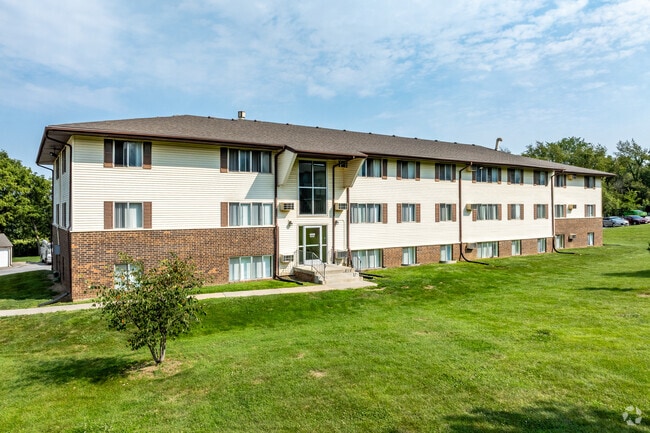
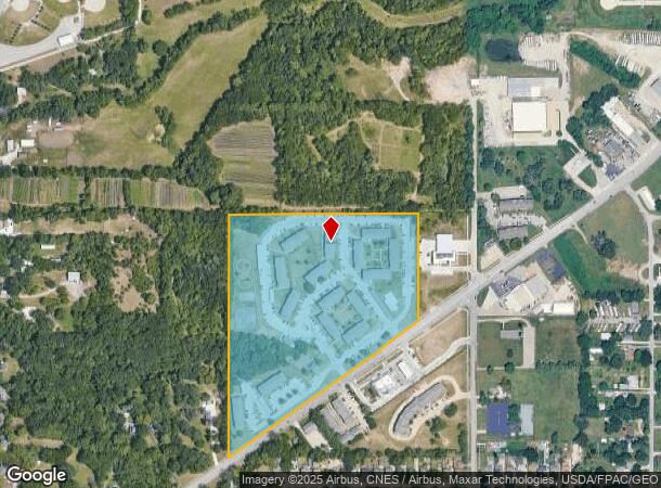
4040 Hubbell Ave
060/06645-005-000
Katherine Place
Apartment
-EX COM CNT SEC 21-79-23 THN S 590.97F W 310.71F TO POB THN SW 255.15F NE 11.53F NE 251.69F S 13.3F TO POB- & -EX SELY 2F- LOT 5 KATHERINE PLACE
X
Polk
19153C0220F
Iowa
2024
22.34 AC
2025
Outer SE Des Moines N
000101
Des Moines
320,429 SF
Des Moines-West Des Moines, IA
DEMOGRAPHICS near 4040 Hubbell Ave
1 Mile
3 Mile
5 Mile
2024 Total Population
7,757
39,458
105,496
2029 Population
8,099
40,998
109,965
Pop Growth 2024-2029
+ 4.41%
+ 3.90%
+ 4.24%
Average Age
38
40
38
2024 Total Households
3,160
15,780
40,269
HH Growth 2024-2029
+ 4.59%
+ 4.03%
+ 4.41%
Median Household Inc
$55,962
$62,562
$62,928
Avg Household Size
2.40
2.40
2.50
2024 Avg HH Vehicles
2.00
2.00
2.00
Median Home Value
$166,922
$165,733
$170,247
Median Year Built
1973
1971
1971
Nearby Places
Map Layers
Map Styles
 Street
 Aerial
- Restaurants
- Banks
- Shops
- Fitness
- Groceries
PUBLIC TRANSPORTATION
AIRPORT
Des Moines International
DRIVE
WALK
Distance
Des Moines International
24 min
11.9 mi
Freight Ports
Port Milwaukee
DRIVE
WALK
Distance
Port Milwaukee
407 min
366.3 mi
Nearby Properties
Address
Land Use
TOTAL SIZE
Lot Size
Zoning
Address
Land Use
TOTAL SIZE
Lot Size
Zoning
1,232,488 SF
184.19 AC
Address
Land Use
TOTAL SIZE
Lot Size
Zoning
1,089,208 SF
145.90 AC
Address
Land Use
TOTAL SIZE
Lot Size
Zoning
1,018,608 SF
190.56 AC
Address
Land Use
TOTAL SIZE
Lot Size
Zoning
549,615 SF
149.20 AC
C6
Address
Land Use
TOTAL SIZE
Lot Size
Zoning
675,000 SF
65.27 AC
Address
Land Use
TOTAL SIZE
Lot Size
Zoning
350,879 SF
16.14 AC
Address
Land Use
TOTAL SIZE
Lot Size
Zoning
333,079 SF
34.07 AC
Address
Land Use
TOTAL SIZE
Lot Size
Zoning
146,138 SF
22.78 AC
C-3
Address
Land Use
TOTAL SIZE
Lot Size
Zoning
359,441 SF
173.80 AC
C6
Address
Land Use
TOTAL SIZE
Lot Size
Zoning
312,500 SF
38.14 AC
Address
Land Use
TOTAL SIZE
Lot Size
Zoning
300,000 SF
18.95 AC
Address
Land Use
TOTAL SIZE
Lot Size
Zoning
300,000 SF
20.09 AC
Address
Land Use
TOTAL SIZE
Lot Size
Zoning
270,000 SF
18.35 AC
Address
Land Use
TOTAL SIZE
Lot Size
Zoning
270,000 SF
14.55 AC
Address
Land Use
TOTAL SIZE
Lot Size
Zoning
529,161 SF
33.60 AC
HI
Address
Land Use
TOTAL SIZE
Lot Size
Zoning
126,935 SF
28.61 AC
Address
Land Use
TOTAL SIZE
Lot Size
Zoning
603,502 SF
33.03 AC
M-1
Address
Land Use
TOTAL SIZE
Lot Size
Zoning
220,740 SF
23.21 AC
Address
Land Use
TOTAL SIZE
Lot Size
Zoning
90,325 SF
5.49 AC
PUD
Address
Land Use
TOTAL SIZE
Lot Size
Zoning
170,872 SF
25 AC
Address
Land Use
TOTAL SIZE
Lot Size
Zoning
136,900 SF
28.82 AC
Address
Land Use
TOTAL SIZE
Lot Size
Zoning
142,118 SF
10.59 AC
PUD
Address
Land Use
TOTAL SIZE
Lot Size
Zoning
205,728 SF
21.74 AC
Address
Land Use
TOTAL SIZE
Lot Size
Zoning
155,276 SF
6.66 AC
R-4
Address
Land Use
TOTAL SIZE
Lot Size
Zoning
183,595 SF
19.31 AC
C-2
Address
Land Use
TOTAL SIZE
Lot Size
Zoning
181,492 SF
12.32 AC
M1
Address
Land Use
TOTAL SIZE
Lot Size
Zoning
79,823 SF
11.47 AC
M2
Address
Land Use
TOTAL SIZE
Lot Size
Zoning
71,666 SF
18.40 AC
R1-80
Address
Land Use
TOTAL SIZE
Lot Size
Zoning
199,180 SF
9.64 AC
M-1
The World's #1 Commercial Real Estate Marketplace
Connect with us
© 2026 CoStar Group
The information above has been obtained from sources believed reliable. While we do not doubt its accuracy we have not verified it and make no guarantee, warranty or representation about it. It is your responsibility to independently confirm its accuracy and completeness. Any projections, opinions, assumptions, or estimates used are for example only and do not represent the current or future performance of the property. The value of this transaction to you depends on tax and other factors which should be evaluated by your tax, financial, and legal advisors. You and your advisors should conduct a careful, independent investigation of the property to determine to your satisfaction the suitability of the property for your needs.