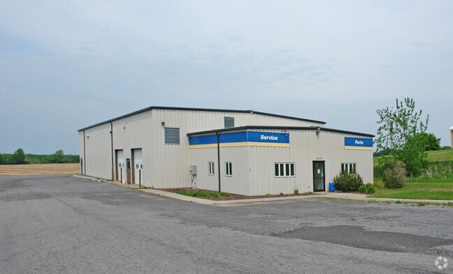
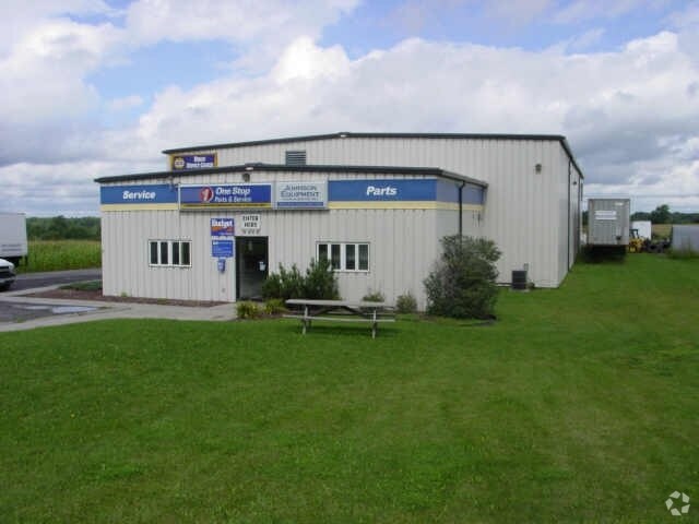
Property Record
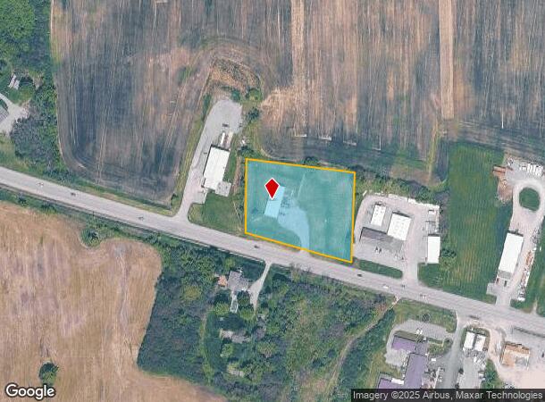
4042 State Route 5 And 20, Canandaigua, NY 14424

NEARBY LISTINGS FOR SALE OR LEASE
Property Detail
4042 State Route 5 And 20
Rochester, NY
2.1 ACRES
323400-099-000-0001-027-112
Ontario
Storesoffices
New York
2025
27.112
2024
2.10 AC
051200
Outlying Ontario County
4,000 SF
Rochester
DEMOGRAPHICS near 4042 State Route 5 And 20
1 Mile
3 Mile
5 Mile
2024 Total Population
1,171
6,797
23,876
2029 Population
1,132
6,854
24,020
Pop Growth 2024-2029
(3.33%)
+ 0.84%
+ 0.60%
Average Age
38
45
45
2024 Total Households
382
2,899
10,321
HH Growth 2024-2029
(4.45%)
+ 1.10%
+ 0.70%
Median Household Inc
$53,200
$69,698
$73,047
Avg Household Size
2.10
2.10
2.10
2024 Avg HH Vehicles
2.00
2.00
2.00
Median Home Value
$83,441
$207,270
$230,431
Median Year Built
1986
1983
1978
Nearby Places
- Restaurants
- Banks
- Shops
- Fitness
- Groceries
PUBLIC TRANSPORTATION
AIRPORT
Frederick Douglass/Greater Rochester International
DRIVE
WALK
Distance
Frederick Douglass/Greater Rochester International
48 min
33.4 mi
Nearby Properties
Address
Land Use
TOTAL SIZE
Lot Size
Zoning
Address
Land Use
TOTAL SIZE
Lot Size
Zoning
Address
Land Use
TOTAL SIZE
Lot Size
Zoning
97.20 AC
R1
Address
Land Use
TOTAL SIZE
Lot Size
Zoning
202,319 SF
2.69 AC
PUD
Address
Land Use
TOTAL SIZE
Lot Size
Zoning
100,758 SF
5.80 AC
PUD
Address
Land Use
TOTAL SIZE
Lot Size
Zoning
46,212 SF
8.40 AC
CL
Address
Land Use
TOTAL SIZE
Lot Size
Zoning
39,480 SF
10.90 AC
PUD
Address
Land Use
TOTAL SIZE
Lot Size
Zoning
130,803 SF
7.20 AC
C1
Address
Land Use
TOTAL SIZE
Lot Size
Zoning
194,786 SF
17.90 AC
C1
Address
Land Use
TOTAL SIZE
Lot Size
Zoning
3,716 SF
6.60 AC
PR
Address
Land Use
TOTAL SIZE
Lot Size
Zoning
90.40 AC
AG
Address
Land Use
TOTAL SIZE
Lot Size
Zoning
114,533 SF
16.90 AC
C3
Address
Land Use
TOTAL SIZE
Lot Size
Zoning
196,012 SF
17.80 AC
CC
Address
Land Use
TOTAL SIZE
Lot Size
Zoning
Address
Land Use
TOTAL SIZE
Lot Size
Zoning
Address
Land Use
TOTAL SIZE
Lot Size
Zoning
3,053 SF
16.20 AC
M1
Address
Land Use
TOTAL SIZE
Lot Size
Zoning
135,054 SF
11.80 AC
C1
Address
Land Use
TOTAL SIZE
Lot Size
Zoning
40.30 AC
HDR
Address
Land Use
TOTAL SIZE
Lot Size
Zoning
101,854 SF
3.60 AC
R3
Address
Land Use
TOTAL SIZE
Lot Size
Zoning
Address
Land Use
TOTAL SIZE
Lot Size
Zoning
Address
Land Use
TOTAL SIZE
Lot Size
Zoning
Address
Land Use
TOTAL SIZE
Lot Size
Zoning
Address
Land Use
TOTAL SIZE
Lot Size
Zoning
32,306 SF
16 AC
M1
Address
Land Use
TOTAL SIZE
Lot Size
Zoning
67,902 SF
7.80 AC
C3
Address
Land Use
TOTAL SIZE
Lot Size
Zoning
Address
Land Use
TOTAL SIZE
Lot Size
Zoning
31,442 SF
5.20 AC
C3
Address
Land Use
TOTAL SIZE
Lot Size
Zoning
19,363 SF
2.90 AC
CL
Address
Land Use
TOTAL SIZE
Lot Size
Zoning
3,660 SF
13.60 AC
R3
Address
Land Use
TOTAL SIZE
Lot Size
Zoning
92,532 SF
10.30 AC
PUD
Address
Land Use
TOTAL SIZE
Lot Size
Zoning
14,356 SF
1.74 AC
C3
The World's #1 Commercial Real Estate Marketplace
Connect with us
© 2025 CoStar Group
The information above has been obtained from sources believed reliable. While we do not doubt its accuracy we have not verified it and make no guarantee, warranty or representation about it. It is your responsibility to independently confirm its accuracy and completeness. Any projections, opinions, assumptions, or estimates used are for example only and do not represent the current or future performance of the property. The value of this transaction to you depends on tax and other factors which should be evaluated by your tax, financial, and legal advisors. You and your advisors should conduct a careful, independent investigation of the property to determine to your satisfaction the suitability of the property for your needs.