Property Record
40445 W Honeycutt Rd, Maricopa, AZ 85138
NEARBY LISTINGS FOR SALE OR LEASE
Property Detail
40445 W Honeycutt Rd
Phoenix-Mesa-Scottsdale, AZ
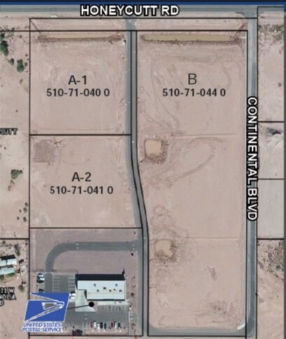
Honeycutt Business Park
510-71-041
PARCEL B OF HONEYCUTT BUSINESS PARK IN NW NE OF SEC 25 04S 03E CA B H SLD 076 6.12 AC
Vacantlandnec
Pinal
X
Arizona
04021C0745F
1.89 AC
2024
Pinal County
2025
Phoenix
001713
DEMOGRAPHICS near 40445 W Honeycutt Rd
1 Mile
3 Mile
5 Mile
2024 Total Population
10,521
57,464
69,878
2029 Population
13,308
72,915
88,558
Pop Growth 2024-2029
+ 26.49%
+ 26.89%
+ 26.73%
Average Age
38
38
38
2024 Total Households
3,546
18,954
22,705
HH Growth 2024-2029
+ 26.65%
+ 26.76%
+ 26.59%
Median Household Inc
$80,628
$90,502
$88,984
Avg Household Size
3.00
3.00
3.00
2024 Avg HH Vehicles
2.00
2.00
2.00
Median Home Value
$335,210
$323,554
$320,008
Median Year Built
2010
2007
2007
Nearby Places
Map Layers
Map Styles
 Street
 Aerial
- Restaurants
- Banks
- Shops
- Fitness
- Groceries
PUBLIC TRANSPORTATION
COMMUTER RAIL
Maricopa (Sunset Limited - Amtrak, Texas Eagle - Amtrak)
DRIVE
WALK
Distance
Maricopa (Sunset Limited - Amtrak, Texas Eagle - Amtrak)
5 min
2.8 mi
AIRPORT
Phoenix Sky Harbor International
DRIVE
WALK
Distance
Phoenix Sky Harbor International
47 min
32.5 mi
Phoenix-Mesa Gateway
DRIVE
WALK
Distance
Phoenix-Mesa Gateway
55 min
37.6 mi
Freight Ports
Port of San Diego
DRIVE
WALK
Distance
Port of San Diego
371 min
343.0 mi
Nearby Properties
Address
Land Use
TOTAL SIZE
Lot Size
Zoning
Address
Land Use
TOTAL SIZE
Lot Size
Zoning
189,104 SF
20.99 AC
Address
Land Use
TOTAL SIZE
Lot Size
Zoning
112,719 SF
14.37 AC
UNDESIGNAT
Address
Land Use
TOTAL SIZE
Lot Size
Zoning
58,073 SF
5.74 AC
Address
Land Use
TOTAL SIZE
Lot Size
Zoning
102,212 SF
11.98 AC
Address
Land Use
TOTAL SIZE
Lot Size
Zoning
78,634 SF
7.83 AC
Address
Land Use
TOTAL SIZE
Lot Size
Zoning
57,070 SF
9.05 AC
Address
Land Use
TOTAL SIZE
Lot Size
Zoning
92,929 SF
11.43 AC
Address
Land Use
TOTAL SIZE
Lot Size
Zoning
12.02 AC
UNDESIGNAT
Address
Land Use
TOTAL SIZE
Lot Size
Zoning
20,801 SF
1.94 AC
Address
Land Use
TOTAL SIZE
Lot Size
Zoning
39,454 SF
5 AC
Address
Land Use
TOTAL SIZE
Lot Size
Zoning
83,747 SF
5.01 AC
Address
Land Use
TOTAL SIZE
Lot Size
Zoning
134,977 SF
4.53 AC
Address
Land Use
TOTAL SIZE
Lot Size
Zoning
124,122 SF
2.38 AC
Address
Land Use
TOTAL SIZE
Lot Size
Zoning
Address
Land Use
TOTAL SIZE
Lot Size
Zoning
19.14 AC
Address
Land Use
TOTAL SIZE
Lot Size
Zoning
Address
Land Use
TOTAL SIZE
Lot Size
Zoning
38,864 SF
5.38 AC
Address
Land Use
TOTAL SIZE
Lot Size
Zoning
25,287 SF
2.72 AC
UNDESIGNAT
Address
Land Use
TOTAL SIZE
Lot Size
Zoning
8,537 SF
6.71 AC
Address
Land Use
TOTAL SIZE
Lot Size
Zoning
14.67 AC
Address
Land Use
TOTAL SIZE
Lot Size
Zoning
26.11 AC
Address
Land Use
TOTAL SIZE
Lot Size
Zoning
13.31 AC
UNDESIGNAT
Address
Land Use
TOTAL SIZE
Lot Size
Zoning
51,440 SF
4.99 AC
Address
Land Use
TOTAL SIZE
Lot Size
Zoning
84,308 SF
2.10 AC
UNDESIGNAT
Address
Land Use
TOTAL SIZE
Lot Size
Zoning
The World's #1 Commercial Real Estate Marketplace
Connect with us
© 2025 CoStar Group
The information above has been obtained from sources believed reliable. While we do not doubt its accuracy we have not verified it and make no guarantee, warranty or representation about it. It is your responsibility to independently confirm its accuracy and completeness. Any projections, opinions, assumptions, or estimates used are for example only and do not represent the current or future performance of the property. The value of this transaction to you depends on tax and other factors which should be evaluated by your tax, financial, and legal advisors. You and your advisors should conduct a careful, independent investigation of the property to determine to your satisfaction the suitability of the property for your needs.