Property Record
4045 Randleman Rd, Greensboro, NC 27406
NEARBY LISTINGS FOR SALE OR LEASE
Property Detail
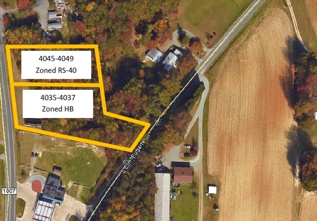
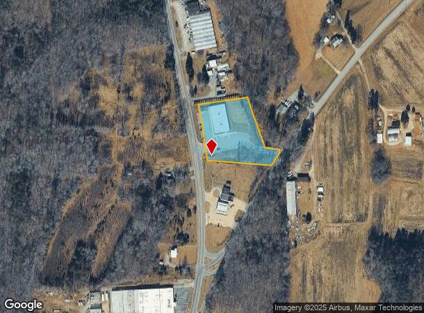
4045 Randleman Rd
Greensboro-High Point, NC
Georgetowne Square Condo
0142778
SCM MAINTENANCE/ACCESS PL:208-140
Commercialnec
Guilford
X
North Carolina
3710786100J
29
2024
1.74 AC
2025
South Greensboro
016800
Greensboro/Winston-Salem
9,100 SF
DEMOGRAPHICS near 4045 Randleman Rd
1 Mile
3 Mile
5 Mile
2024 Total Population
2,642
24,087
67,301
2029 Population
2,612
23,870
66,885
Pop Growth 2024-2029
(1.14%)
(0.90%)
(0.62%)
Average Age
37
39
39
2024 Total Households
1,041
9,918
27,448
HH Growth 2024-2029
(1.15%)
(0.92%)
(0.62%)
Median Household Inc
$65,771
$56,409
$50,445
Avg Household Size
2.50
2.40
2.40
2024 Avg HH Vehicles
2.00
2.00
2.00
Median Home Value
$133,854
$144,038
$152,214
Median Year Built
1995
1986
1981
Nearby Places
Map Layers
Map Styles
 Street
 Aerial
- Restaurants
- Banks
- Shops
- Fitness
- Groceries
PUBLIC TRANSPORTATION
COMMUTER RAIL
Greensboro Station (Piedmont - North Carolina by Train (NC Train))
DRIVE
WALK
Distance
Greensboro Station (Piedmont - North Carolina by Train (NC Train))
10 min
6.6 mi
AIRPORT
Piedmont Triad International
DRIVE
WALK
Distance
Piedmont Triad International
24 min
15.1 mi
Freight Ports
Port of Wilmington
DRIVE
WALK
Distance
Port of Wilmington
244 min
213.2 mi
SALE & LEASE HISTORY
LISTING DATE
SALE/LEASE

Sep 24, 2016
For Sale
Nearby Properties
Address
Land Use
TOTAL SIZE
Lot Size
Zoning
Address
Land Use
TOTAL SIZE
Lot Size
Zoning
412,479 SF
19.68 AC
RM-26
Address
Land Use
TOTAL SIZE
Lot Size
Zoning
252,351 SF
9.48 AC
RM-18
Address
Land Use
TOTAL SIZE
Lot Size
Zoning
300,901 SF
20.39 AC
RM-18
Address
Land Use
TOTAL SIZE
Lot Size
Zoning
280,200 SF
19.28 AC
RM-12
Address
Land Use
TOTAL SIZE
Lot Size
Zoning
201,999 SF
22.18 AC
C-H
Address
Land Use
TOTAL SIZE
Lot Size
Zoning
188,976 SF
41.46 AC
R-5
Address
Land Use
TOTAL SIZE
Lot Size
Zoning
97,679 SF
17.18 AC
PI
Address
Land Use
TOTAL SIZE
Lot Size
Zoning
172,950 SF
11.49 AC
RM-18
Address
Land Use
TOTAL SIZE
Lot Size
Zoning
118,707 SF
15.94 AC
C-H
Address
Land Use
TOTAL SIZE
Lot Size
Zoning
107,867 SF
14.75 AC
RM-8
Address
Land Use
TOTAL SIZE
Lot Size
Zoning
112,960 SF
23.36 AC
PI
Address
Land Use
TOTAL SIZE
Lot Size
Zoning
111,810 SF
5.88 AC
O
Address
Land Use
TOTAL SIZE
Lot Size
Zoning
158,500 SF
17.35 AC
RM-12
Address
Land Use
TOTAL SIZE
Lot Size
Zoning
184,330 SF
10.92 AC
RM-12
Address
Land Use
TOTAL SIZE
Lot Size
Zoning
49,728 SF
9.29 AC
PI
Address
Land Use
TOTAL SIZE
Lot Size
Zoning
114,434 SF
10.89 AC
RM-12
Address
Land Use
TOTAL SIZE
Lot Size
Zoning
95,304 SF
4.58 AC
RM-12
Address
Land Use
TOTAL SIZE
Lot Size
Zoning
117,356 SF
10.11 AC
RM-12
Address
Land Use
TOTAL SIZE
Lot Size
Zoning
177,850 SF
93.40 AC
AG
Address
Land Use
TOTAL SIZE
Lot Size
Zoning
451,367 SF
50.59 AC
LI
Address
Land Use
TOTAL SIZE
Lot Size
Zoning
152,820 SF
9 AC
RM-12
Address
Land Use
TOTAL SIZE
Lot Size
Zoning
55,923 SF
37.65 AC
C-M
Address
Land Use
TOTAL SIZE
Lot Size
Zoning
79,560 SF
8.23 AC
RM-12
Address
Land Use
TOTAL SIZE
Lot Size
Zoning
83,832 SF
7.63 AC
RM-12
Address
Land Use
TOTAL SIZE
Lot Size
Zoning
109,740 SF
6.41 AC
LI
Address
Land Use
TOTAL SIZE
Lot Size
Zoning
77,658 SF
6.27 AC
C-H
Address
Land Use
TOTAL SIZE
Lot Size
Zoning
85,191 SF
10.09 AC
RM-12
Address
Land Use
TOTAL SIZE
Lot Size
Zoning
105,301 SF
10.08 AC
RM-12
Address
Land Use
TOTAL SIZE
Lot Size
Zoning
154,028 SF
17.91 AC
LI
Address
Land Use
TOTAL SIZE
Lot Size
Zoning
121,176 SF
7.49 AC
LI
The World's #1 Commercial Real Estate Marketplace
Connect with us
© 2026 CoStar Group
The information above has been obtained from sources believed reliable. While we do not doubt its accuracy we have not verified it and make no guarantee, warranty or representation about it. It is your responsibility to independently confirm its accuracy and completeness. Any projections, opinions, assumptions, or estimates used are for example only and do not represent the current or future performance of the property. The value of this transaction to you depends on tax and other factors which should be evaluated by your tax, financial, and legal advisors. You and your advisors should conduct a careful, independent investigation of the property to determine to your satisfaction the suitability of the property for your needs.