Property Record
4046 Albany Post Rd, Hyde Park, NY 12538
NEARBY LISTINGS FOR SALE OR LEASE
Property Detail
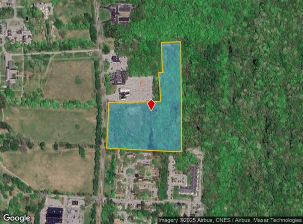
4046 Albany Post Rd
Dutchess County-Putnam County, NY
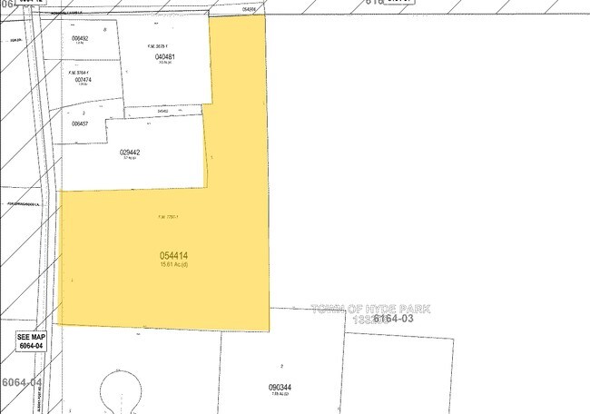
15.61 AC (D) 1245 0733
133200-6164-03-054414-0000
Dutchess
Commercialacreage
New York
X
54
36027C0268E
15.61 AC
0
Fishkill
2024
Westchester/So Connecticut
070201
DEMOGRAPHICS near 4046 Albany Post Rd
1 Mile
3 Mile
5 Mile
2024 Total Population
1,215
16,962
67,416
2029 Population
1,197
16,981
67,452
Pop Growth 2024-2029
(1.48%)
+ 0.11%
+ 0.05%
Average Age
45
41
40
2024 Total Households
576
6,264
25,673
HH Growth 2024-2029
(1.39%)
+ 0.03%
+ 0.13%
Median Household Inc
$52,631
$81,638
$63,269
Avg Household Size
2.10
2.30
2.30
2024 Avg HH Vehicles
1.00
2.00
2.00
Median Home Value
$256,089
$259,520
$261,738
Median Year Built
1961
1967
1965
Nearby Places
- Restaurants
- Banks
- Shops
- Fitness
- Groceries
PUBLIC TRANSPORTATION
COMMUTER RAIL
Poughkeepsie Station (Hudson Line - Metro-North Commuter Railroad Company (Metro-North))
DRIVE
WALK
Distance
Poughkeepsie Station (Hudson Line - Metro-North Commuter Railroad Company (Metro-North))
7 min
4.7 mi
AIRPORT
New York Stewart International
DRIVE
WALK
Distance
New York Stewart International
40 min
28.2 mi
Freight Ports
Albany, NY Port
DRIVE
WALK
Distance
Albany, NY Port
93 min
66.0 mi
Nearby Properties
Address
Land Use
TOTAL SIZE
Lot Size
Zoning
Address
Land Use
TOTAL SIZE
Lot Size
Zoning
317,644 SF
35.25 AC
CIA
Address
Land Use
TOTAL SIZE
Lot Size
Zoning
12,638 SF
159.73 AC
R2A
Address
Land Use
TOTAL SIZE
Lot Size
Zoning
103,108 SF
24.31 AC
HRDD
Address
Land Use
TOTAL SIZE
Lot Size
Zoning
15.50 AC
N
Address
Land Use
TOTAL SIZE
Lot Size
Zoning
123,218 SF
15.07 AC
FC
Address
Land Use
TOTAL SIZE
Lot Size
Zoning
120,508 SF
30.85 AC
IN
Address
Land Use
TOTAL SIZE
Lot Size
Zoning
830,000 SF
3.49 AC
Address
Land Use
TOTAL SIZE
Lot Size
Zoning
5,665 SF
510.60 AC
R40
Address
Land Use
TOTAL SIZE
Lot Size
Zoning
53,841 SF
195.70 AC
WF
Address
Land Use
TOTAL SIZE
Lot Size
Zoning
26,000 SF
12.67 AC
IN
Address
Land Use
TOTAL SIZE
Lot Size
Zoning
169,527 SF
56.30 AC
N
Address
Land Use
TOTAL SIZE
Lot Size
Zoning
Address
Land Use
TOTAL SIZE
Lot Size
Zoning
59,792 SF
2.70 AC
CIA
Address
Land Use
TOTAL SIZE
Lot Size
Zoning
14,786 SF
24.80 AC
R40
Address
Land Use
TOTAL SIZE
Lot Size
Zoning
3.60 AC
R20
Address
Land Use
TOTAL SIZE
Lot Size
Zoning
59,424 SF
15.41 AC
TCHD
Address
Land Use
TOTAL SIZE
Lot Size
Zoning
32,644 SF
1.97 AC
IN
Address
Land Use
TOTAL SIZE
Lot Size
Zoning
64,351 SF
24.40 AC
R20
Address
Land Use
TOTAL SIZE
Lot Size
Zoning
97,100 SF
5.80 AC
LI
Address
Land Use
TOTAL SIZE
Lot Size
Zoning
132,561 SF
15 AC
TCHD
Address
Land Use
TOTAL SIZE
Lot Size
Zoning
21,440 SF
33.20 AC
WF
Address
Land Use
TOTAL SIZE
Lot Size
Zoning
108,714 SF
64.17 AC
N
Address
Land Use
TOTAL SIZE
Lot Size
Zoning
57,706 SF
9.10 AC
R20
Address
Land Use
TOTAL SIZE
Lot Size
Zoning
49,334 SF
16.30 AC
WF
Address
Land Use
TOTAL SIZE
Lot Size
Zoning
100 SF
115.31 AC
HRDD
Address
Land Use
TOTAL SIZE
Lot Size
Zoning
82,330 SF
31.80 AC
GB
Address
Land Use
TOTAL SIZE
Lot Size
Zoning
47,524 SF
13 AC
N
Address
Land Use
TOTAL SIZE
Lot Size
Zoning
62,402 SF
9.10 AC
N
Address
Land Use
TOTAL SIZE
Lot Size
Zoning
45,912 SF
0.63 AC
CIA
Address
Land Use
TOTAL SIZE
Lot Size
Zoning
21,464 SF
7.69 AC
EPBD
The World's #1 Commercial Real Estate Marketplace
Connect with us
© 2025 CoStar Group
The information above has been obtained from sources believed reliable. While we do not doubt its accuracy we have not verified it and make no guarantee, warranty or representation about it. It is your responsibility to independently confirm its accuracy and completeness. Any projections, opinions, assumptions, or estimates used are for example only and do not represent the current or future performance of the property. The value of this transaction to you depends on tax and other factors which should be evaluated by your tax, financial, and legal advisors. You and your advisors should conduct a careful, independent investigation of the property to determine to your satisfaction the suitability of the property for your needs.