Property Record
4048 Main St, Pinson, AL 35126

NEARBY LISTINGS FOR SALE OR LEASE
Property Detail
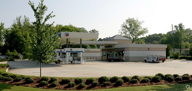
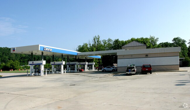
4048 Main St
09-00-31-3-004-004.000
COM NW COR OF SW 1/4 SEC 31 TP 15 R 1W TH E 772 FT TH SWLY 1545 FT TO POB TH CONT SWLY 100 FT TH SW 24 FT TH NW 155 FT TH NE 210 FT TH SE 75 FT TH SW 80 FT TH SE 135 FT TO POB
Storebuilding
Jefferson
AE
Alabama
01073C0237H
0.61 AC
2023
Fultondale
2024
Birmingham
011206
Birmingham-Hoover, AL
2,400 SF
DEMOGRAPHICS near 4048 Main St
1 Mile
3 Mile
5 Mile
2024 Total Population
2,330
25,413
66,102
2029 Population
2,255
24,882
64,805
Pop Growth 2024-2029
(3.22%)
(2.09%)
(1.96%)
Average Age
38
36
37
2024 Total Households
881
9,372
24,697
HH Growth 2024-2029
(3.29%)
(2.14%)
(2.00%)
Median Household Inc
$60,244
$50,978
$51,838
Avg Household Size
2.60
2.70
2.60
2024 Avg HH Vehicles
2.00
2.00
2.00
Median Home Value
$158,588
$152,801
$151,908
Median Year Built
1978
1977
1978
Nearby Places
Map Layers
Map Styles
 Street
 Aerial
- Restaurants
- Banks
- Shops
- Fitness
- Groceries
PUBLIC TRANSPORTATION
AIRPORT
Birmingham-Shuttlesworth International
DRIVE
WALK
Distance
Birmingham-Shuttlesworth International
23 min
12.8 mi
Freight Ports
Port of Mobile
DRIVE
WALK
Distance
Port of Mobile
301 min
270.6 mi
Nearby Properties
Address
Land Use
TOTAL SIZE
Lot Size
Zoning
Address
Land Use
TOTAL SIZE
Lot Size
Zoning
192,596 SF
13.79 AC
CR5
Address
Land Use
TOTAL SIZE
Lot Size
Zoning
147,200 SF
7.93 AC
CR5
Address
Land Use
TOTAL SIZE
Lot Size
Zoning
531,808 SF
23.96 AC
I4&A
Address
Land Use
TOTAL SIZE
Lot Size
Zoning
502,302 SF
24.61 AC
I4&A
Address
Land Use
TOTAL SIZE
Lot Size
Zoning
117,342 SF
36 AC
I
Address
Land Use
TOTAL SIZE
Lot Size
Zoning
81,817 SF
9.30 AC
C1
Address
Land Use
TOTAL SIZE
Lot Size
Zoning
80,834 SF
7.13 AC
CR5
Address
Land Use
TOTAL SIZE
Lot Size
Zoning
26,169 SF
71 AC
R2
Address
Land Use
TOTAL SIZE
Lot Size
Zoning
109,878 SF
10 AC
C1
Address
Land Use
TOTAL SIZE
Lot Size
Zoning
56,504 SF
2 AC
C1-C
Address
Land Use
TOTAL SIZE
Lot Size
Zoning
63,736 SF
11 AC
I
Address
Land Use
TOTAL SIZE
Lot Size
Zoning
113,175 SF
21.85 AC
I2
Address
Land Use
TOTAL SIZE
Lot Size
Zoning
61,472 SF
18.84 AC
INT-
Address
Land Use
TOTAL SIZE
Lot Size
Zoning
147,810 SF
13 AC
I4
Address
Land Use
TOTAL SIZE
Lot Size
Zoning
3.56 AC
CR6&
Address
Land Use
TOTAL SIZE
Lot Size
Zoning
84,282 SF
5.57 AC
R4
Address
Land Use
TOTAL SIZE
Lot Size
Zoning
49,384 SF
2.87 AC
CR5
Address
Land Use
TOTAL SIZE
Lot Size
Zoning
329,728 SF
29.40 AC
I4&A
Address
Land Use
TOTAL SIZE
Lot Size
Zoning
70,567 SF
6.10 AC
I4
Address
Land Use
TOTAL SIZE
Lot Size
Zoning
58,816 SF
2.98 AC
C1
Address
Land Use
TOTAL SIZE
Lot Size
Zoning
109,646 SF
6.40 AC
Address
Land Use
TOTAL SIZE
Lot Size
Zoning
58,316 SF
6.10 AC
B2
Address
Land Use
TOTAL SIZE
Lot Size
Zoning
76,321 SF
9.26 AC
I-2
Address
Land Use
TOTAL SIZE
Lot Size
Zoning
40,535 SF
4 AC
INST
Address
Land Use
TOTAL SIZE
Lot Size
Zoning
43,064 SF
2.33 AC
CR5
Address
Land Use
TOTAL SIZE
Lot Size
Zoning
68,811 SF
11 AC
I4
Address
Land Use
TOTAL SIZE
Lot Size
Zoning
37,531 SF
2.64 AC
C1-R
Address
Land Use
TOTAL SIZE
Lot Size
Zoning
29,932 SF
12.40 AC
INST
Address
Land Use
TOTAL SIZE
Lot Size
Zoning
55,720 SF
12 AC
I4
Address
Land Use
TOTAL SIZE
Lot Size
Zoning
34,755 SF
1.28 AC
INST
The World's #1 Commercial Real Estate Marketplace
Connect with us
© 2026 CoStar Group
The information above has been obtained from sources believed reliable. While we do not doubt its accuracy we have not verified it and make no guarantee, warranty or representation about it. It is your responsibility to independently confirm its accuracy and completeness. Any projections, opinions, assumptions, or estimates used are for example only and do not represent the current or future performance of the property. The value of this transaction to you depends on tax and other factors which should be evaluated by your tax, financial, and legal advisors. You and your advisors should conduct a careful, independent investigation of the property to determine to your satisfaction the suitability of the property for your needs.