Property Record
4048 Porter Mountain Rd, Lakeside, AZ 85929


Property Detail
4048 Porter Mountain Rd
Show Low, AZ
PORTER CREEK ESTATES:LOT 5; EXCEPT: BEG NW COR LOT 5; TH S00DEG49 11W 245.64; TH N89DEG3852E 130.42; TH N00DEG0307E 170.05 ; TH N89DEG1149E 48.73; TH N00DEG2051W 75.16; TH S89DEG390 9W 176.66 TPOB. OUT OF 212-12-005 FOR 2019 ROLL
212-12-005A
Navajo
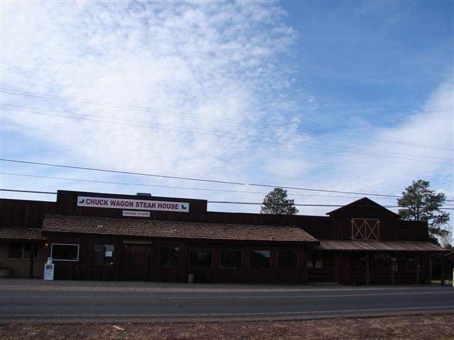
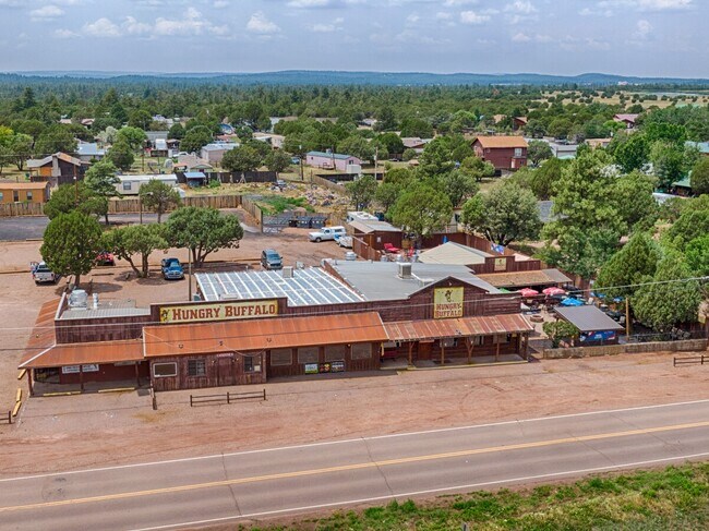
Restaurantbuilding
Arizona
B and X Area of moderate flood hazard, usually the area between the limits of the 100-year and 500-year floods.
5
2025
1.51 AC
2027
Arizona Northeast & Holbrook Area
961701
Other Market Areas
7,815 SF
NEARBY LISTINGS FOR SALE OR LEASE
DEMOGRAPHICS near 4048 Porter Mountain Rd
1 mile
3 mile
5 mile
2025 Total Population
300
8,944
16,902
2030 Population
322
9,443
18,063
Pop Growth 2025-2030
+ 7.33%
+ 5.58%
+ 6.87%
Average Age
44
44
45
2025 Total Households
118
3,543
6,690
HH Growth 2025-2030
+ 6.78%
+ 5.02%
+ 6.43%
Median Household Inc
$62,812
$54,840
$58,037
Avg Household Size
2.50
2.40
2.50
2025 Avg HH Vehicles
2.00
2.00
2.00
Median Home Value
$345,454
$312,008
$329,473
Median Year Built
1990
1987
1990
Nearby Places
Map Layers
Map Styles
 Street
 Aerial
Layers
 Traffic
 Biking
Places
Listings with unknown addresses are not visible on the map
- Restaurants
- Banks
- Shops
- Fitness
- Groceries
SALE & LEASE HISTORY
LISTING DATE
SALE/LEASE

Nov 11, 2021
For Sale
Jul 27, 2018
For Lease
Jul 20, 2018
For Sale
Jul 16, 2024
For Sale
Jul 04, 2024
For Sale
Apr 20, 2023
For Sale
Nearby Properties
Address
Land Use
TOTAL SIZE
Lot Size
Zoning
Address
Land Use
TOTAL SIZE
Lot Size
Zoning
10,821.02 AC
Address
Land Use
TOTAL SIZE
Lot Size
Zoning
209,240 SF
14 AC
MUNICIPAL
Address
Land Use
TOTAL SIZE
Lot Size
Zoning
138,315 SF
Address
Land Use
TOTAL SIZE
Lot Size
Zoning
4,308 SF
73.88 AC
MUNICIPAL
Address
Land Use
TOTAL SIZE
Lot Size
Zoning
138,315 SF
13.91 AC
MUNICIPAL
Address
Land Use
TOTAL SIZE
Lot Size
Zoning
99,979 SF
10.70 AC
MUNICIPAL
Address
Land Use
TOTAL SIZE
Lot Size
Zoning
83,087 SF
5.08 AC
MUNICIPAL
Address
Land Use
TOTAL SIZE
Lot Size
Zoning
56,096 SF
1.48 AC
C-R
Address
Land Use
TOTAL SIZE
Lot Size
Zoning
44,764 SF
1.51 AC
MUNICIPAL
Address
Land Use
TOTAL SIZE
Lot Size
Zoning
97,790 SF
4.80 AC
MUNICIPAL
Address
Land Use
TOTAL SIZE
Lot Size
Zoning
26,530 SF
3.88 AC
C-R
Address
Land Use
TOTAL SIZE
Lot Size
Zoning
22,680 SF
1.65 AC
C-R
Address
Land Use
TOTAL SIZE
Lot Size
Zoning
20,555 SF
19.27 AC
MUNICIPAL
Address
Land Use
TOTAL SIZE
Lot Size
Zoning
42,868 SF
2.45 AC
MUNICIPAL
Address
Land Use
TOTAL SIZE
Lot Size
Zoning
48,320 SF
5 AC
C-R
Address
Land Use
TOTAL SIZE
Lot Size
Zoning
27,602 SF
1.53 AC
MUNICIPAL
Address
Land Use
TOTAL SIZE
Lot Size
Zoning
20,088 SF
2 AC
R-2
Address
Land Use
TOTAL SIZE
Lot Size
Zoning
56,290 SF
1.50 AC
C-R
Address
Land Use
TOTAL SIZE
Lot Size
Zoning
16,157 SF
4.56 AC
R1-10
Address
Land Use
TOTAL SIZE
Lot Size
Zoning
46,318 SF
20 AC
MUNICIPAL
Address
Land Use
TOTAL SIZE
Lot Size
Zoning
46,480 SF
4.35 AC
C-R
Address
Land Use
TOTAL SIZE
Lot Size
Zoning
22,389 SF
3.16 AC
MUNICIPAL
Address
Land Use
TOTAL SIZE
Lot Size
Zoning
25,081 SF
3.17 AC
MUNICIPAL
Address
Land Use
TOTAL SIZE
Lot Size
Zoning
25,882 SF
21.67 AC
MUNICIPAL
Address
Land Use
TOTAL SIZE
Lot Size
Zoning
21,333 SF
2.14 AC
C-R
Address
Land Use
TOTAL SIZE
Lot Size
Zoning
9,514 SF
2.40 AC
MUNICIPAL
Address
Land Use
TOTAL SIZE
Lot Size
Zoning
124.42 AC
SD
Address
Land Use
TOTAL SIZE
Lot Size
Zoning
17,925 SF
1.99 AC
MUNICIPAL
Address
Land Use
TOTAL SIZE
Lot Size
Zoning
48,506 SF
3.08 AC
C-R
The World's #1 Commercial Real Estate Marketplace
Connect with us
© 2026 CoStar Group
The information above has been obtained from sources believed reliable. While we do not doubt its accuracy we have not verified it and make no guarantee, warranty or representation about it. It is your responsibility to independently confirm its accuracy and completeness. Any projections, opinions, assumptions, or estimates used are for example only and do not represent the current or future performance of the property. The value of this transaction to you depends on tax and other factors which should be evaluated by your tax, financial, and legal advisors. You and your advisors should conduct a careful, independent investigation of the property to determine to your satisfaction the suitability of the property for your needs.