Property Record
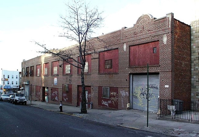
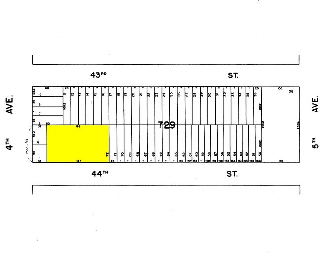
405 44Th St, Brooklyn, NY 11220

Property Detail
405 44Th St
00729-0072
DOCID-2022110400464001
Apartment
Kings
R6B
New York
B and X Area of moderate flood hazard, usually the area between the limits of the 100-year and 500-year floods.
72
0
0.37 AC
2025
South Brooklyn
008200
Long Island (New York)
65,048 SF
New York-Jersey City-White Plains, NY-NJ
NEARBY LISTINGS FOR SALE OR LEASE
DEMOGRAPHICS near 405 44Th St
1 mile
3 mile
5 mile
2025 Total Population
106,063
802,786
2,119,312
2030 Population
100,586
789,210
2,111,619
Pop Growth 2025-2030
(5.16%)
(1.69%)
(0.36%)
Average Age
38
39
39
2025 Total Households
30,570
285,839
782,775
HH Growth 2025-2030
(5.72%)
(1.73%)
(0.30%)
Median Household Inc
$64,230
$90,087
$84,492
Avg Household Size
3.20
2.70
2.60
2025 Avg HH Vehicles
.00
1.00
1.00
Median Home Value
$1,013,441
$1,046,387
$952,089
Median Year Built
1946
1947
1948
Nearby Places
Map Layers
Map Styles
 Street
 Aerial
Transit
 Traffic
 Biking
Places
Listings with unknown addresses are not visible on the map
- Restaurants
- Banks
- Shops
- Fitness
- Groceries
PUBLIC TRANSPORTATION
TRANSIT/SUBWAY
45 Street (N - New York MTA Subway (The Subway), R - New York MTA Subway (The Subway))
Drive
Walk
Distance
45 Street (N - New York MTA Subway (The Subway), R - New York MTA Subway (The Subway))
1 min
1 min
0.1 mi
36 Street (D,M,N,R Line) (D - New York MTA Subway (The Subway), M - New York MTA Subway (The Subway), N - New York MTA Subway (The Subway), R - New York MTA Subway (The Subway))
Drive
Walk
Distance
36 Street (D,M,N,R Line) (D - New York MTA Subway (The Subway), M - New York MTA Subway (The Subway), N - New York MTA Subway (The Subway), R - New York MTA Subway (The Subway))
2 min
9 min
0.4 mi
53 Street (N - New York MTA Subway (The Subway), R - New York MTA Subway (The Subway))
Drive
Walk
Distance
53 Street (N - New York MTA Subway (The Subway), R - New York MTA Subway (The Subway))
2 min
9 min
0.5 mi
59 Street (N,R Line) (N - New York MTA Subway (The Subway), R - New York MTA Subway (The Subway))
Drive
Walk
Distance
59 Street (N,R Line) (N - New York MTA Subway (The Subway), R - New York MTA Subway (The Subway))
3 min
15 min
0.8 mi
9 Avenue (D - New York MTA Subway (The Subway), M - New York MTA Subway (The Subway))
Drive
Walk
Distance
9 Avenue (D - New York MTA Subway (The Subway), M - New York MTA Subway (The Subway))
3 min
18 min
0.9 mi
COMMUTER RAIL
Drive
Walk
Distance
11 min
3.4 mi
Nostrand Avenue Station (Far Rockaway Branch - Long Island Rail Road, Hempstead Branch - Long Island Rail Road, Long Beach Branch - Long Island Rail Road, West Hempstead Branch - Long Island Rail Road)
Drive
Walk
Distance
Nostrand Avenue Station (Far Rockaway Branch - Long Island Rail Road, Hempstead Branch - Long Island Rail Road, Long Beach Branch - Long Island Rail Road, West Hempstead Branch - Long Island Rail Road)
15 min
4.6 mi
AIRPORT
LaGuardia
Drive
Walk
Distance
LaGuardia
27 min
14.4 mi
John F Kennedy International
Drive
Walk
Distance
John F Kennedy International
29 min
14.5 mi
Newark Liberty International
Drive
Walk
Distance
Newark Liberty International
32 min
17.9 mi
Freight Ports
NY - Red Hook Container Terminal
Drive
Walk
Distance
NY - Red Hook Container Terminal
8 min
3.3 mi
Nearby Properties
Address
Land Use
TOTAL SIZE
Lot Size
Zoning
Address
Land Use
TOTAL SIZE
Lot Size
Zoning
869,038 SF
1.53 AC
M1-1
Address
Land Use
TOTAL SIZE
Lot Size
Zoning
92,440 SF
466.23 AC
R5
Address
Land Use
TOTAL SIZE
Lot Size
Zoning
2,542,066 SF
174.49 AC
R3-2
Address
Land Use
TOTAL SIZE
Lot Size
Zoning
393.54 AC
PARK
Address
Land Use
TOTAL SIZE
Lot Size
Zoning
1,524,659 SF
170.96 AC
R4
Address
Land Use
TOTAL SIZE
Lot Size
Zoning
577,381 SF
3.19 AC
R6
Address
Land Use
TOTAL SIZE
Lot Size
Zoning
902,000 SF
6.44 AC
M3-1
Address
Land Use
TOTAL SIZE
Lot Size
Zoning
965,600 SF
6.65 AC
R5
Address
Land Use
TOTAL SIZE
Lot Size
Zoning
460,000 SF
3.21 AC
R6
Address
Land Use
TOTAL SIZE
Lot Size
Zoning
627,018 SF
1.21 AC
C6-4
Address
Land Use
TOTAL SIZE
Lot Size
Zoning
335,800 SF
1.51 AC
R6
Address
Land Use
TOTAL SIZE
Lot Size
Zoning
1,324,592 SF
5.13 AC
M3-1
Address
Land Use
TOTAL SIZE
Lot Size
Zoning
296,915 SF
0.31 AC
C5-3
Address
Land Use
TOTAL SIZE
Lot Size
Zoning
397,354 SF
0.61 AC
C5-2
Address
Land Use
TOTAL SIZE
Lot Size
Zoning
566,000 SF
12.33 AC
R6
Address
Land Use
TOTAL SIZE
Lot Size
Zoning
389,125 SF
3.48 AC
C6-4
Address
Land Use
TOTAL SIZE
Lot Size
Zoning
489,344 SF
3.78 AC
C6-4
Address
Land Use
TOTAL SIZE
Lot Size
Zoning
427,208 SF
1.30 AC
R6
Address
Land Use
TOTAL SIZE
Lot Size
Zoning
258,000 SF
1.86 AC
R6
Address
Land Use
TOTAL SIZE
Lot Size
Zoning
393,092 SF
1.07 AC
R8A
Address
Land Use
TOTAL SIZE
Lot Size
Zoning
371,139 SF
3.22 AC
R5
Address
Land Use
TOTAL SIZE
Lot Size
Zoning
5,359,400 SF
59.07 AC
M2-1
Address
Land Use
TOTAL SIZE
Lot Size
Zoning
286,000 SF
12.63 AC
PARK
Address
Land Use
TOTAL SIZE
Lot Size
Zoning
1,785,288 SF
22.38 AC
M2-1
Address
Land Use
TOTAL SIZE
Lot Size
Zoning
3,970,000 SF
91.14 AC
M3-1
Address
Land Use
TOTAL SIZE
Lot Size
Zoning
517,033 SF
0.92 AC
C6-4
Address
Land Use
TOTAL SIZE
Lot Size
Zoning
1,466,751 SF
24.79 AC
R5
Address
Land Use
TOTAL SIZE
Lot Size
Zoning
689,850 SF
3.08 AC
M3-1
Address
Land Use
TOTAL SIZE
Lot Size
Zoning
336,534 SF
47.78 AC
M1-1
Address
Land Use
TOTAL SIZE
Lot Size
Zoning
308,757 SF
0.74 AC
R7-1
The World's #1 Commercial Real Estate Marketplace
Connect with us
© 2026 CoStar Group
The information above has been obtained from sources believed reliable. While we do not doubt its accuracy we have not verified it and make no guarantee, warranty or representation about it. It is your responsibility to independently confirm its accuracy and completeness. Any projections, opinions, assumptions, or estimates used are for example only and do not represent the current or future performance of the property. The value of this transaction to you depends on tax and other factors which should be evaluated by your tax, financial, and legal advisors. You and your advisors should conduct a careful, independent investigation of the property to determine to your satisfaction the suitability of the property for your needs.