Property Record
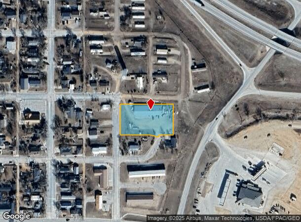
405 E Weston St, Moorcroft, WY 82721
NEARBY LISTINGS FOR SALE OR LEASE
-
-
View all Moorcroft listings for sale on LoopNet.com
Property Detail
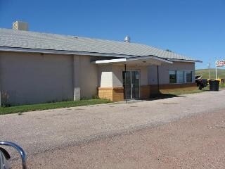
405 E Weston St
Shipyard
T 50N R 67W SEC 31 SESE TRACT A TOTAL ACRES: 1.21 1960 BRICK BOWLING ALLEY 7560 SQ FT ASPHALT PARKING 4202 SQ FT 1997 STORAGE SHED 16 X 20 1960 STORAGE SHED 12 X 20 NKA HAZ MATTERS OFFICE
X
Crook
5600770014B
Wyoming
2023
2.42 AC
2025
Wyoming Area
950200
Other Market Areas
7,560 SF
5067-31-4-00-001.95
DEMOGRAPHICS near 405 E Weston St
1 Mile
3 Mile
5 Mile
2024 Total Population
978
1,109
1,380
2029 Population
1,023
1,160
1,445
Pop Growth 2024-2029
+ 4.60%
+ 4.60%
+ 4.71%
Average Age
35
35
36
2024 Total Households
351
398
503
HH Growth 2024-2029
+ 4.56%
+ 4.52%
+ 4.77%
Median Household Inc
$68,888
$68,951
$71,412
Avg Household Size
2.80
2.80
2.70
2024 Avg HH Vehicles
3.00
3.00
3.00
Median Home Value
$262,499
$261,585
$280,302
Median Year Built
1986
1986
1986
Nearby Places
Map Layers
Map Styles
 Street
 Aerial
- Restaurants
- Banks
- Shops
- Fitness
- Groceries
Nearby Properties
Address
Land Use
TOTAL SIZE
Lot Size
Zoning
Address
Land Use
TOTAL SIZE
Lot Size
Zoning
11,319 SF
9.08 AC
Address
Land Use
TOTAL SIZE
Lot Size
Zoning
21,380 SF
36.27 AC
Address
Land Use
TOTAL SIZE
Lot Size
Zoning
8,602 SF
29,519.40 AC
Address
Land Use
TOTAL SIZE
Lot Size
Zoning
7,368 SF
0.63 AC
Address
Land Use
TOTAL SIZE
Lot Size
Zoning
108.49 AC
Address
Land Use
TOTAL SIZE
Lot Size
Zoning
9,110 SF
2 AC
Address
Land Use
TOTAL SIZE
Lot Size
Zoning
9,894 SF
10,562.22 AC
Address
Land Use
TOTAL SIZE
Lot Size
Zoning
5,308 SF
32,549.25 AC
Address
Land Use
TOTAL SIZE
Lot Size
Zoning
23,266.68 AC
Address
Land Use
TOTAL SIZE
Lot Size
Zoning
11,832 SF
0.55 AC
Address
Land Use
TOTAL SIZE
Lot Size
Zoning
14,640 SF
0.89 AC
Address
Land Use
TOTAL SIZE
Lot Size
Zoning
3,216 SF
0.32 AC
Address
Land Use
TOTAL SIZE
Lot Size
Zoning
13,260 SF
5 AC
Address
Land Use
TOTAL SIZE
Lot Size
Zoning
13,200 SF
65.79 AC
Address
Land Use
TOTAL SIZE
Lot Size
Zoning
4,354 SF
1.93 AC
Address
Land Use
TOTAL SIZE
Lot Size
Zoning
6,772 SF
0.64 AC
Address
Land Use
TOTAL SIZE
Lot Size
Zoning
5,668 SF
1.36 AC
Address
Land Use
TOTAL SIZE
Lot Size
Zoning
4,469 SF
3.42 AC
Address
Land Use
TOTAL SIZE
Lot Size
Zoning
7,260 SF
6.87 AC
Address
Land Use
TOTAL SIZE
Lot Size
Zoning
3,312 SF
0.16 AC
Address
Land Use
TOTAL SIZE
Lot Size
Zoning
7,496 SF
17.76 AC
Address
Land Use
TOTAL SIZE
Lot Size
Zoning
3,200 SF
0.12 AC
Address
Land Use
TOTAL SIZE
Lot Size
Zoning
9,000 SF
2.40 AC
Address
Land Use
TOTAL SIZE
Lot Size
Zoning
10,898 SF
10.80 AC
Address
Land Use
TOTAL SIZE
Lot Size
Zoning
5,130 SF
0.48 AC
Address
Land Use
TOTAL SIZE
Lot Size
Zoning
3,100 SF
0.96 AC
Address
Land Use
TOTAL SIZE
Lot Size
Zoning
6,674 SF
8 AC
Address
Land Use
TOTAL SIZE
Lot Size
Zoning
4,032 SF
0.21 AC
Address
Land Use
TOTAL SIZE
Lot Size
Zoning
1,908 SF
0.16 AC
The World's #1 Commercial Real Estate Marketplace
Connect with us
© 2026 CoStar Group
The information above has been obtained from sources believed reliable. While we do not doubt its accuracy we have not verified it and make no guarantee, warranty or representation about it. It is your responsibility to independently confirm its accuracy and completeness. Any projections, opinions, assumptions, or estimates used are for example only and do not represent the current or future performance of the property. The value of this transaction to you depends on tax and other factors which should be evaluated by your tax, financial, and legal advisors. You and your advisors should conduct a careful, independent investigation of the property to determine to your satisfaction the suitability of the property for your needs.