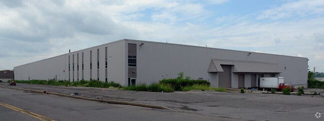
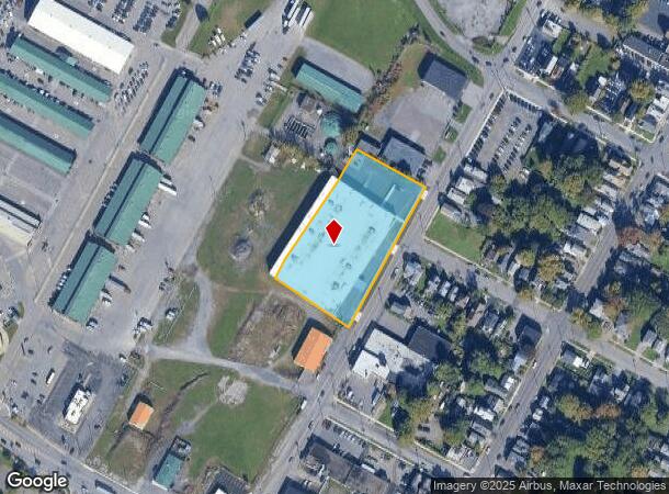
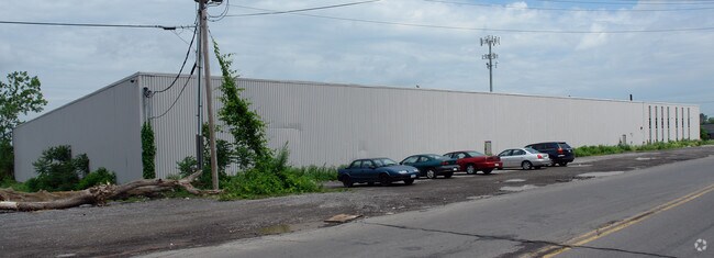
Property Record
405 Hiawatha Blvd E, Syracuse, NY 13208
NEARBY LISTINGS FOR SALE OR LEASE
Property Detail
405 Hiawatha Blvd E
311500-001-002-0002-008-000-0000
Onondaga
Warehouse
New York
X
8.000
36067C0208F
2.21 AC
2025
Greater Syracuse
2024
Syracuse
000100
Syracuse, NY
62,000 SF
DEMOGRAPHICS near 405 Hiawatha Blvd E
1 Mile
3 Mile
5 Mile
2024 Total Population
12,064
113,075
239,082
2029 Population
11,709
110,254
233,687
Pop Growth 2024-2029
(2.94%)
(2.49%)
(2.26%)
Average Age
35
37
39
2024 Total Households
4,614
48,441
99,220
HH Growth 2024-2029
(3.10%)
(2.44%)
(2.35%)
Median Household Inc
$33,749
$42,081
$52,515
Avg Household Size
2.50
2.10
2.20
2024 Avg HH Vehicles
1.00
1.00
1.00
Median Home Value
$87,193
$120,111
$141,932
Median Year Built
1947
1951
1954
Nearby Places
- Restaurants
- Banks
- Shops
- Fitness
- Groceries
PUBLIC TRANSPORTATION
COMMUTER RAIL
DRIVE
WALK
Distance
2 min
11 min
0.5 mi
DRIVE
WALK
Distance
2 min
11 min
0.6 mi
AIRPORT
Syracuse Hancock International
DRIVE
WALK
Distance
Syracuse Hancock International
9 min
5.5 mi
SALE & LEASE HISTORY
LISTING DATE
SALE/LEASE

May 01, 2019
For Lease
Jan 23, 2017
For Lease
Jan 09, 2017
For Sale
Nearby Properties
Address
Land Use
TOTAL SIZE
Lot Size
Zoning
Address
Land Use
TOTAL SIZE
Lot Size
Zoning
847,042 SF
42.78 AC
23
Address
Land Use
TOTAL SIZE
Lot Size
Zoning
57,011 SF
22.53 AC
22
Address
Land Use
TOTAL SIZE
Lot Size
Zoning
508,658 SF
2.23 AC
25
Address
Land Use
TOTAL SIZE
Lot Size
Zoning
848,000 SF
30.29 AC
Address
Land Use
TOTAL SIZE
Lot Size
Zoning
459,040 SF
4.71 AC
06 - INDUS
Address
Land Use
TOTAL SIZE
Lot Size
Zoning
826,528 SF
2.28 AC
06 - INDUS
Address
Land Use
TOTAL SIZE
Lot Size
Zoning
269,030 SF
11.90 AC
05 - COMME
Address
Land Use
TOTAL SIZE
Lot Size
Zoning
72,200 SF
12.39 AC
06 - INDUS
Address
Land Use
TOTAL SIZE
Lot Size
Zoning
409,062 SF
10
Address
Land Use
TOTAL SIZE
Lot Size
Zoning
522,469 SF
1.87 AC
14
Address
Land Use
TOTAL SIZE
Lot Size
Zoning
218,051 SF
2.32 AC
25
Address
Land Use
TOTAL SIZE
Lot Size
Zoning
6,598 SF
4.09 AC
14
Address
Land Use
TOTAL SIZE
Lot Size
Zoning
24,360 SF
3.99 AC
10
Address
Land Use
TOTAL SIZE
Lot Size
Zoning
108,368 SF
3.36 AC
14
Address
Land Use
TOTAL SIZE
Lot Size
Zoning
414,700 SF
1.94 AC
07 - MIXED
Address
Land Use
TOTAL SIZE
Lot Size
Zoning
1.67 AC
06 - INDUS
Address
Land Use
TOTAL SIZE
Lot Size
Zoning
653,177 SF
1.94 AC
13
Address
Land Use
TOTAL SIZE
Lot Size
Zoning
224,736 SF
2.48 AC
10
Address
Land Use
TOTAL SIZE
Lot Size
Zoning
165,800 SF
1.27 AC
25
Address
Land Use
TOTAL SIZE
Lot Size
Zoning
164,837 SF
0.66 AC
10
Address
Land Use
TOTAL SIZE
Lot Size
Zoning
105,004 SF
2.81 AC
25
Address
Land Use
TOTAL SIZE
Lot Size
Zoning
316,848 SF
10.72 AC
08 - GOVER
Address
Land Use
TOTAL SIZE
Lot Size
Zoning
13,800 SF
2.10 AC
16
Address
Land Use
TOTAL SIZE
Lot Size
Zoning
275,732 SF
2.91 AC
13
Address
Land Use
TOTAL SIZE
Lot Size
Zoning
296,703 SF
1.48 AC
25
Address
Land Use
TOTAL SIZE
Lot Size
Zoning
307,860 SF
1.17 AC
25
Address
Land Use
TOTAL SIZE
Lot Size
Zoning
5,837 SF
1.26 AC
15
Address
Land Use
TOTAL SIZE
Lot Size
Zoning
31,947 SF
1.23 AC
Address
Land Use
TOTAL SIZE
Lot Size
Zoning
278,208 SF
1.92 AC
25
Address
Land Use
TOTAL SIZE
Lot Size
Zoning
134,400 SF
1.18 AC
25
The World's #1 Commercial Real Estate Marketplace
Connect with us
© 2025 CoStar Group
The information above has been obtained from sources believed reliable. While we do not doubt its accuracy we have not verified it and make no guarantee, warranty or representation about it. It is your responsibility to independently confirm its accuracy and completeness. Any projections, opinions, assumptions, or estimates used are for example only and do not represent the current or future performance of the property. The value of this transaction to you depends on tax and other factors which should be evaluated by your tax, financial, and legal advisors. You and your advisors should conduct a careful, independent investigation of the property to determine to your satisfaction the suitability of the property for your needs.