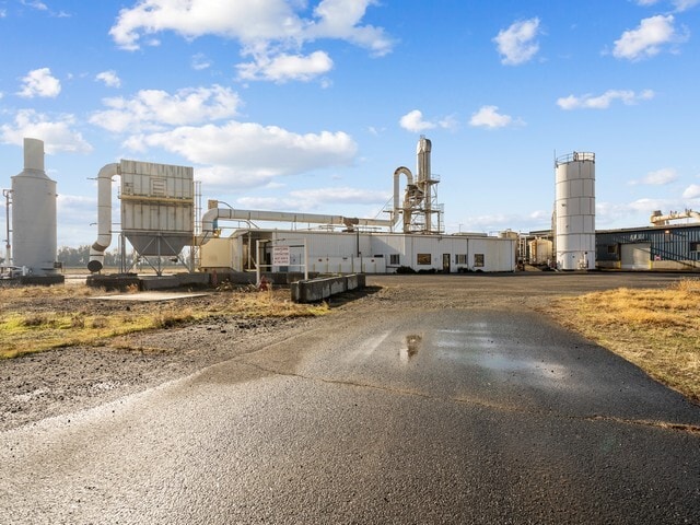
Property Record
405 Hoosier Rd, Stanfield, OR 97875


Current Lease Availabilities
Property Detail
405 Hoosier Rd
Foodprocessing
UMATILLA
GI
Oregon
C and X Area of minimal flood hazard, usually depicted on FIRMs as above the 500-year flood level.
10 AC
2025
Oregon East Area
2025
Other Market Areas
951300
Hermiston-Pendleton, OR
10 SF
164224
NEARBY LISTINGS FOR SALE OR LEASE
-
-
View all Stanfield listings for lease on LoopNet.com
DEMOGRAPHICS near 405 Hoosier Rd
1 mile
3 mile
5 mile
2025 Total Population
1,850
2,606
11,646
2030 Population
1,868
2,623
11,704
Pop Growth 2025-2030
+ 0.97%
+ 0.65%
+ 0.50%
Average Age
38
39
37
2025 Total Households
670
955
4,131
HH Growth 2025-2030
+ 0.90%
+ 0.52%
+ 0.48%
Median Household Inc
$56,410
$56,226
$64,807
Avg Household Size
2.80
2.70
2.80
2025 Avg HH Vehicles
2.00
2.00
2.00
Median Home Value
$217,347
$228,287
$316,277
Median Year Built
1975
1974
1978
Nearby Places
Map Layers
Map Styles
 Street
 Aerial
Layers
 Traffic
 Biking
Places
Listings with unknown addresses are not visible on the map
- Restaurants
- Banks
- Shops
- Fitness
- Groceries
Nearby Properties
Address
Land Use
TOTAL SIZE
Lot Size
Zoning
Address
Land Use
TOTAL SIZE
Lot Size
Zoning
1,144,892 SF
186.54 AC
C-2,M-2
Address
Land Use
TOTAL SIZE
Lot Size
Zoning
571.50 AC
EFU, F-1,
Address
Land Use
TOTAL SIZE
Lot Size
Zoning
48,499 SF
18.35 AC
R
Address
Land Use
TOTAL SIZE
Lot Size
Zoning
52,320 SF
3.41 AC
M-1,C-2
Address
Land Use
TOTAL SIZE
Lot Size
Zoning
10,570 SF
14.69 AC
D-TC
Address
Land Use
TOTAL SIZE
Lot Size
Zoning
10 SF
17.19 AC
C-2,M-1
Address
Land Use
TOTAL SIZE
Lot Size
Zoning
10 SF
10 AC
GI
Address
Land Use
TOTAL SIZE
Lot Size
Zoning
18,196 SF
3.16 AC
RLI
Address
Land Use
TOTAL SIZE
Lot Size
Zoning
32,300 SF
1.50 AC
C-2
Address
Land Use
TOTAL SIZE
Lot Size
Zoning
576 SF
0.50 AC
D-TC
Address
Land Use
TOTAL SIZE
Lot Size
Zoning
37,200 SF
2.69 AC
M-1
Address
Land Use
TOTAL SIZE
Lot Size
Zoning
6,430 SF
4.57 AC
C-2,M-1
Address
Land Use
TOTAL SIZE
Lot Size
Zoning
8,004 SF
3.12 AC
M-1
Address
Land Use
TOTAL SIZE
Lot Size
Zoning
24,100 SF
1.92 AC
M-1
Address
Land Use
TOTAL SIZE
Lot Size
Zoning
12,020 SF
1.32 AC
R
Address
Land Use
TOTAL SIZE
Lot Size
Zoning
10,845 SF
1.02 AC
LI
Address
Land Use
TOTAL SIZE
Lot Size
Zoning
23,610 SF
8.35 AC
M-1
Address
Land Use
TOTAL SIZE
Lot Size
Zoning
10 SF
5.54 AC
LI
Address
Land Use
TOTAL SIZE
Lot Size
Zoning
20,736 SF
0.92 AC
R-MF
Address
Land Use
TOTAL SIZE
Lot Size
Zoning
9,046 SF
EFU
Address
Land Use
TOTAL SIZE
Lot Size
Zoning
28.49 AC
HI
Address
Land Use
TOTAL SIZE
Lot Size
Zoning
17,456 SF
2.37 AC
R-MF,D
Address
Land Use
TOTAL SIZE
Lot Size
Zoning
4,512 SF
0.95 AC
C-2
Address
Land Use
TOTAL SIZE
Lot Size
Zoning
6,912 SF
1.57 AC
TC
Address
Land Use
TOTAL SIZE
Lot Size
Zoning
10 SF
0.97 AC
PUD, M-1.
Address
Land Use
TOTAL SIZE
Lot Size
Zoning
7,410 SF
1.20 AC
R-4
The World's #1 Commercial Real Estate Marketplace
Connect with us
© 2026 CoStar Group
The information above has been obtained from sources believed reliable. While we do not doubt its accuracy we have not verified it and make no guarantee, warranty or representation about it. It is your responsibility to independently confirm its accuracy and completeness. Any projections, opinions, assumptions, or estimates used are for example only and do not represent the current or future performance of the property. The value of this transaction to you depends on tax and other factors which should be evaluated by your tax, financial, and legal advisors. You and your advisors should conduct a careful, independent investigation of the property to determine to your satisfaction the suitability of the property for your needs.