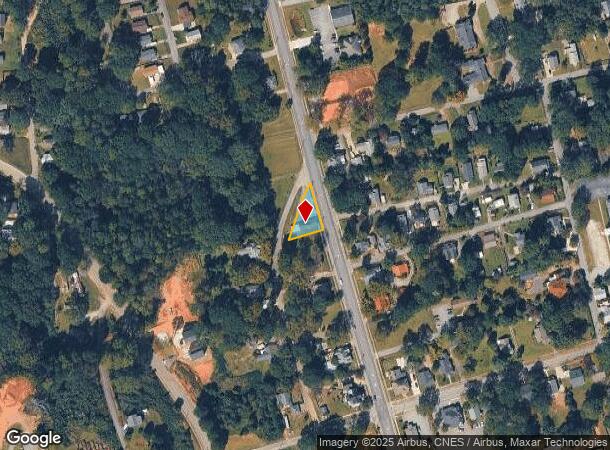
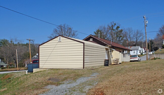
Property Record
405 N A St, Easley, SC 29640

NEARBY LISTINGS FOR SALE OR LEASE
Property Detail
405 N A St
5019-12-85-8459
SW/CORNER ELLENBURG DR N A ST
Officebuilding
Pickens
X
South Carolina
45077C0303D
0.21 AC
2025
Pickens County
2024
Greenville/Spartanburg
010805
Greenville-Anderson-Greer, SC
1,045 SF
DEMOGRAPHICS near 405 N A St
1 Mile
3 Mile
5 Mile
2024 Total Population
6,416
28,272
50,826
2029 Population
6,769
29,741
53,265
Pop Growth 2024-2029
+ 5.50%
+ 5.20%
+ 4.80%
Average Age
41
41
41
2024 Total Households
2,829
11,808
20,563
HH Growth 2024-2029
+ 5.59%
+ 5.28%
+ 4.88%
Median Household Inc
$38,510
$49,791
$55,348
Avg Household Size
2.20
2.30
2.40
2024 Avg HH Vehicles
2.00
2.00
2.00
Median Home Value
$140,595
$168,596
$181,478
Median Year Built
1974
1983
1988
Nearby Places
Map Layers
Map Styles
 Street
 Aerial
- Restaurants
- Banks
- Shops
- Fitness
- Groceries
PUBLIC TRANSPORTATION
AIRPORT
Greenville Spartanburg International
DRIVE
WALK
Distance
Greenville Spartanburg International
43 min
28.1 mi
Freight Ports
North Charleston Terminal
DRIVE
WALK
Distance
North Charleston Terminal
246 min
214.5 mi
Nearby Properties
Address
Land Use
TOTAL SIZE
Lot Size
Zoning
Address
Land Use
TOTAL SIZE
Lot Size
Zoning
2,291 SF
6.44 AC
GR2
Address
Land Use
TOTAL SIZE
Lot Size
Zoning
81,245 SF
8.49 AC
GC
Address
Land Use
TOTAL SIZE
Lot Size
Zoning
10,906 SF
2.59 AC
CORE COMME
Address
Land Use
TOTAL SIZE
Lot Size
Zoning
19,164 SF
3.22 AC
GC
Address
Land Use
TOTAL SIZE
Lot Size
Zoning
24,362 SF
3.84 AC
GENERAL CO
Address
Land Use
TOTAL SIZE
Lot Size
Zoning
21.71 AC
GR2
Address
Land Use
TOTAL SIZE
Lot Size
Zoning
3,344 SF
3.04 AC
GR2
Address
Land Use
TOTAL SIZE
Lot Size
Zoning
9,800 SF
5.94 AC
R10
Address
Land Use
TOTAL SIZE
Lot Size
Zoning
3.60 AC
CORE COMME
Address
Land Use
TOTAL SIZE
Lot Size
Zoning
49,803 SF
18.36 AC
GC
Address
Land Use
TOTAL SIZE
Lot Size
Zoning
30,000 SF
3.30 AC
Address
Land Use
TOTAL SIZE
Lot Size
Zoning
4,200 SF
0.98 AC
GC
Address
Land Use
TOTAL SIZE
Lot Size
Zoning
220,956 SF
16.80 AC
GENERAL CO
Address
Land Use
TOTAL SIZE
Lot Size
Zoning
20,406 SF
1.26 AC
CORE COMME
Address
Land Use
TOTAL SIZE
Lot Size
Zoning
27,700 SF
12.91 AC
Address
Land Use
TOTAL SIZE
Lot Size
Zoning
39,480 SF
3.26 AC
Address
Land Use
TOTAL SIZE
Lot Size
Zoning
5,427 SF
1.34 AC
Address
Land Use
TOTAL SIZE
Lot Size
Zoning
8.96 AC
R 10 ONE F
Address
Land Use
TOTAL SIZE
Lot Size
Zoning
7.30 AC
R 10 ONE F
Address
Land Use
TOTAL SIZE
Lot Size
Zoning
4,450 SF
1.28 AC
MED MEDICA
Address
Land Use
TOTAL SIZE
Lot Size
Zoning
27.43 AC
R 10 ONE F
Address
Land Use
TOTAL SIZE
Lot Size
Zoning
7.09 AC
GC
Address
Land Use
TOTAL SIZE
Lot Size
Zoning
21,258 SF
15 AC
GR2
Address
Land Use
TOTAL SIZE
Lot Size
Zoning
19.43 AC
Address
Land Use
TOTAL SIZE
Lot Size
Zoning
104,889 SF
10.68 AC
GC
Address
Land Use
TOTAL SIZE
Lot Size
Zoning
5,508 SF
4.78 AC
Address
Land Use
TOTAL SIZE
Lot Size
Zoning
3,299 SF
0.32 AC
GENERAL CO
Address
Land Use
TOTAL SIZE
Lot Size
Zoning
1,436 SF
1.62 AC
OC OFFICE
Address
Land Use
TOTAL SIZE
Lot Size
Zoning
1.84 AC
LI
Address
Land Use
TOTAL SIZE
Lot Size
Zoning
55 AC
R 10 ONE F
The World's #1 Commercial Real Estate Marketplace
Connect with us
© 2026 CoStar Group
The information above has been obtained from sources believed reliable. While we do not doubt its accuracy we have not verified it and make no guarantee, warranty or representation about it. It is your responsibility to independently confirm its accuracy and completeness. Any projections, opinions, assumptions, or estimates used are for example only and do not represent the current or future performance of the property. The value of this transaction to you depends on tax and other factors which should be evaluated by your tax, financial, and legal advisors. You and your advisors should conduct a careful, independent investigation of the property to determine to your satisfaction the suitability of the property for your needs.