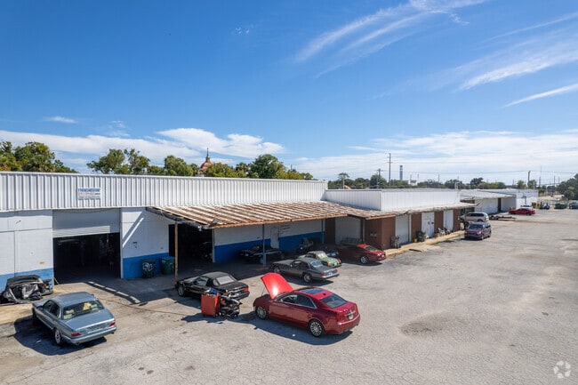
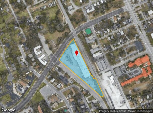
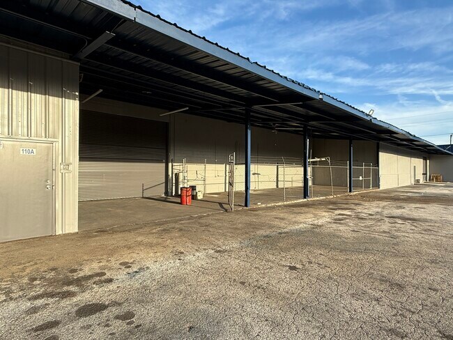
Property Record
405 N Charles St, Daytona Beach, FL 32114
Current Lease Availabilities
NEARBY LISTINGS FOR SALE OR LEASE
Property Detail
405 N Charles St
Deltona-Daytona Beach-Ormond Beach, FL
Weavers Property Mb
5338-20-03-0171
38-15-33 LOTS 1 THRU 4 & N 5 FT OF LOT 5 BLK 3 EXC PT IN ST & LOT 1 BLK 1 G WEAVERS PROPERTY MB 2 PG 114 MB 12 PG 134 OF MASON & COLEMANS DAYTONA DB I PG 151 MB 14 PGS 9-10 EXC PT IN ST & ALL OF ADJ ABANDONED HARRIS & CYPRESS STS & INC THAT PT OF LOT
Lumberyard
Volusia
A
Florida
12127C0359J
1,17-
2025
3.45 AC
2026
Downtown Daytona Beach
081900
Deltona/Daytona Beach
44,245 SF
DEMOGRAPHICS near 405 N Charles St
1 Mile
3 Mile
5 Mile
2024 Total Population
11,446
68,900
134,948
2029 Population
12,732
76,934
150,839
Pop Growth 2024-2029
+ 11.24%
+ 11.66%
+ 11.78%
Average Age
38
42
44
2024 Total Households
4,111
30,160
60,834
HH Growth 2024-2029
+ 11.87%
+ 12.07%
+ 12.32%
Median Household Inc
$31,732
$40,301
$44,458
Avg Household Size
2.10
2.10
2.00
2024 Avg HH Vehicles
1.00
1.00
1.00
Median Home Value
$148,863
$170,837
$190,931
Median Year Built
1971
1973
1978
Nearby Places
Map Layers
Map Styles
 Street
 Aerial
- Restaurants
- Banks
- Shops
- Fitness
- Groceries
PUBLIC TRANSPORTATION
AIRPORT
Daytona Beach International
DRIVE
WALK
Distance
Daytona Beach International
11 min
5.4 mi
Freight Ports
Port Canaveral
DRIVE
WALK
Distance
Port Canaveral
89 min
73.3 mi
Nearby Properties
Address
Land Use
TOTAL SIZE
Lot Size
Zoning
Address
Land Use
TOTAL SIZE
Lot Size
Zoning
1,365,998 SF
13 AC
Address
Land Use
TOTAL SIZE
Lot Size
Zoning
1,842,969 SF
25.56 AC
Address
Land Use
TOTAL SIZE
Lot Size
Zoning
1,058,116 SF
54.22 AC
Address
Land Use
TOTAL SIZE
Lot Size
Zoning
664,082 SF
38.16 AC
02BA
Address
Land Use
TOTAL SIZE
Lot Size
Zoning
880,289 SF
4.98 AC
02T3
Address
Land Use
TOTAL SIZE
Lot Size
Zoning
Address
Land Use
TOTAL SIZE
Lot Size
Zoning
542,849 SF
1.56 AC
02T1
Address
Land Use
TOTAL SIZE
Lot Size
Zoning
472,750 SF
16.76 AC
Address
Land Use
TOTAL SIZE
Lot Size
Zoning
223,127 SF
14.47 AC
Address
Land Use
TOTAL SIZE
Lot Size
Zoning
353,548 SF
50.65 AC
Address
Land Use
TOTAL SIZE
Lot Size
Zoning
275,814 SF
13 AC
Address
Land Use
TOTAL SIZE
Lot Size
Zoning
Address
Land Use
TOTAL SIZE
Lot Size
Zoning
318,230 SF
21.28 AC
Address
Land Use
TOTAL SIZE
Lot Size
Zoning
286,461 SF
945.48 AC
B62
Address
Land Use
TOTAL SIZE
Lot Size
Zoning
300,038 SF
0.22 AC
Address
Land Use
TOTAL SIZE
Lot Size
Zoning
434,487 SF
20.54 AC
Address
Land Use
TOTAL SIZE
Lot Size
Zoning
303,151 SF
13.58 AC
Address
Land Use
TOTAL SIZE
Lot Size
Zoning
226,459 SF
0.57 AC
Address
Land Use
TOTAL SIZE
Lot Size
Zoning
243,418 SF
2.91 AC
02T1
Address
Land Use
TOTAL SIZE
Lot Size
Zoning
560,165 SF
37.79 AC
02BR2
Address
Land Use
TOTAL SIZE
Lot Size
Zoning
155,620 SF
1.81 AC
02T1
Address
Land Use
TOTAL SIZE
Lot Size
Zoning
153,293 SF
10.95 AC
Address
Land Use
TOTAL SIZE
Lot Size
Zoning
207,607 SF
9.83 AC
Address
Land Use
TOTAL SIZE
Lot Size
Zoning
403,130 SF
28.45 AC
Address
Land Use
TOTAL SIZE
Lot Size
Zoning
198,182 SF
7.43 AC
Address
Land Use
TOTAL SIZE
Lot Size
Zoning
146,732 SF
2.12 AC
02T1
Address
Land Use
TOTAL SIZE
Lot Size
Zoning
105,866 SF
5.14 AC
Address
Land Use
TOTAL SIZE
Lot Size
Zoning
460,245 SF
2.92 AC
Address
Land Use
TOTAL SIZE
Lot Size
Zoning
243,686 SF
0.17 AC
Address
Land Use
TOTAL SIZE
Lot Size
Zoning
259,453 SF
2.07 AC
The World's #1 Commercial Real Estate Marketplace
Connect with us
© 2026 CoStar Group
The information above has been obtained from sources believed reliable. While we do not doubt its accuracy we have not verified it and make no guarantee, warranty or representation about it. It is your responsibility to independently confirm its accuracy and completeness. Any projections, opinions, assumptions, or estimates used are for example only and do not represent the current or future performance of the property. The value of this transaction to you depends on tax and other factors which should be evaluated by your tax, financial, and legal advisors. You and your advisors should conduct a careful, independent investigation of the property to determine to your satisfaction the suitability of the property for your needs.