Property Record
405 N Harrisville Rd, Ogden, UT 84404
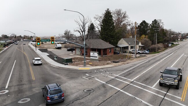
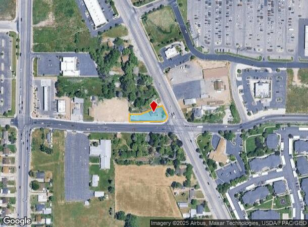
This Property Is For Sale
NEARBY LISTINGS FOR SALE OR LEASE
Property Detail
405 N Harrisville Rd
11-038-0025
Big Sky Estates No 1
Officebuilding
PART OF THE SOUTHEAST QUARTER OF SECTION 8, TOWNSHIP 6 NORTH, RANGE 1 WEST, SALT LAKE BASE AND MERIDIAN: BEGINNING AT A POINT
X
Weber
49057C0213F
Utah
2025
0.35 AC
2025
Davis/Weber Counties
210306
Salt Lake City
1,146 SF
Ogden-Clearfield, UT
DEMOGRAPHICS near 405 N Harrisville Rd
1 Mile
3 Mile
5 Mile
2024 Total Population
13,353
70,061
139,409
2029 Population
14,167
74,645
148,968
Pop Growth 2024-2029
+ 6.10%
+ 6.54%
+ 6.86%
Average Age
35
36
36
2024 Total Households
4,651
24,880
48,591
HH Growth 2024-2029
+ 6.30%
+ 6.72%
+ 7.05%
Median Household Inc
$53,875
$59,911
$65,702
Avg Household Size
2.80
2.70
2.80
2024 Avg HH Vehicles
2.00
2.00
2.00
Median Home Value
$271,303
$319,697
$351,873
Median Year Built
1986
1985
1980
Nearby Places
Map Layers
Map Styles
 Street
 Aerial
- Restaurants
- Banks
- Shops
- Fitness
- Groceries
PUBLIC TRANSPORTATION
COMMUTER RAIL
Ogden (FrontRunner North - Utah Transit Authority (UTA))
DRIVE
WALK
Distance
Ogden (FrontRunner North - Utah Transit Authority (UTA))
7 min
3.2 mi
Roy (FrontRunner North - Utah Transit Authority (UTA))
DRIVE
WALK
Distance
Roy (FrontRunner North - Utah Transit Authority (UTA))
15 min
8.4 mi
AIRPORT
Salt Lake City International
DRIVE
WALK
Distance
Salt Lake City International
54 min
42.3 mi
Nearby Properties
Address
Land Use
TOTAL SIZE
Lot Size
Zoning
Address
Land Use
TOTAL SIZE
Lot Size
Zoning
1,154,674 SF
133.48 AC
Address
Land Use
TOTAL SIZE
Lot Size
Zoning
841,756 SF
45.79 AC
Address
Land Use
TOTAL SIZE
Lot Size
Zoning
111,832 SF
24.92 AC
Address
Land Use
TOTAL SIZE
Lot Size
Zoning
128,867 SF
3.36 AC
Address
Land Use
TOTAL SIZE
Lot Size
Zoning
97,932 SF
3.07 AC
Address
Land Use
TOTAL SIZE
Lot Size
Zoning
52,200 SF
9.95 AC
Address
Land Use
TOTAL SIZE
Lot Size
Zoning
305,444 SF
1.58 AC
Address
Land Use
TOTAL SIZE
Lot Size
Zoning
152,877 SF
4.96 AC
Address
Land Use
TOTAL SIZE
Lot Size
Zoning
9,464 SF
6.82 AC
Address
Land Use
TOTAL SIZE
Lot Size
Zoning
106,752 SF
10.35 AC
Address
Land Use
TOTAL SIZE
Lot Size
Zoning
22,227 SF
10.81 AC
Address
Land Use
TOTAL SIZE
Lot Size
Zoning
66,896 SF
7.50 AC
Address
Land Use
TOTAL SIZE
Lot Size
Zoning
95,949 SF
3.29 AC
Address
Land Use
TOTAL SIZE
Lot Size
Zoning
149,400 SF
26.88 AC
Address
Land Use
TOTAL SIZE
Lot Size
Zoning
183,172 SF
47.62 AC
Address
Land Use
TOTAL SIZE
Lot Size
Zoning
264,373 SF
13.52 AC
Address
Land Use
TOTAL SIZE
Lot Size
Zoning
7,567 SF
5.12 AC
Address
Land Use
TOTAL SIZE
Lot Size
Zoning
596 SF
8.08 AC
Address
Land Use
TOTAL SIZE
Lot Size
Zoning
14,520 SF
6.86 AC
Address
Land Use
TOTAL SIZE
Lot Size
Zoning
108,083 SF
6.21 AC
Address
Land Use
TOTAL SIZE
Lot Size
Zoning
11,248 SF
6.50 AC
Address
Land Use
TOTAL SIZE
Lot Size
Zoning
14,328 SF
4.28 AC
Address
Land Use
TOTAL SIZE
Lot Size
Zoning
202,499 SF
20.48 AC
Address
Land Use
TOTAL SIZE
Lot Size
Zoning
10,336 SF
7.05 AC
The World's #1 Commercial Real Estate Marketplace
Connect with us
© 2025 CoStar Group
The information above has been obtained from sources believed reliable. While we do not doubt its accuracy we have not verified it and make no guarantee, warranty or representation about it. It is your responsibility to independently confirm its accuracy and completeness. Any projections, opinions, assumptions, or estimates used are for example only and do not represent the current or future performance of the property. The value of this transaction to you depends on tax and other factors which should be evaluated by your tax, financial, and legal advisors. You and your advisors should conduct a careful, independent investigation of the property to determine to your satisfaction the suitability of the property for your needs.