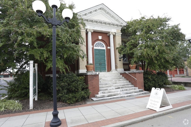
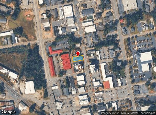
Property Record
405 N Main St, Anderson, SC 29621

NEARBY LISTINGS FOR SALE OR LEASE
Property Detail
405 N Main St
Greenville-Anderson-Mauldin, SC
N Main St
123-29-03-003
CP 000/000 F 0057D 0128 PP 000/000 N MAIN ST
Taxexempt
Anderson
X
South Carolina
45007C0244E
0.17 AC
0
Anderson County
2024
Greenville/Spartanburg
012300
DEMOGRAPHICS near 405 N Main St
1 Mile
3 Mile
5 Mile
2024 Total Population
7,713
44,940
75,202
2029 Population
8,420
48,400
80,646
Pop Growth 2024-2029
+ 9.17%
+ 7.70%
+ 7.24%
Average Age
39
39
40
2024 Total Households
3,141
18,203
30,272
HH Growth 2024-2029
+ 9.42%
+ 7.83%
+ 7.35%
Median Household Inc
$28,134
$40,261
$47,403
Avg Household Size
2.30
2.30
2.40
2024 Avg HH Vehicles
1.00
2.00
2.00
Median Home Value
$85,494
$139,203
$158,880
Median Year Built
1959
1976
1981
Nearby Places
Map Layers
Map Styles
 Street
 Aerial
- Restaurants
- Banks
- Shops
- Fitness
- Groceries
PUBLIC TRANSPORTATION
AIRPORT
Greenville Spartanburg International
DRIVE
WALK
Distance
Greenville Spartanburg International
57 min
40.6 mi
Nearby Properties
Address
Land Use
TOTAL SIZE
Lot Size
Zoning
Address
Land Use
TOTAL SIZE
Lot Size
Zoning
17,286 SF
19.71 AC
Address
Land Use
TOTAL SIZE
Lot Size
Zoning
2,027 SF
12.16 AC
Address
Land Use
TOTAL SIZE
Lot Size
Zoning
15,168 SF
11.99 AC
Address
Land Use
TOTAL SIZE
Lot Size
Zoning
183,500 SF
19.79 AC
Address
Land Use
TOTAL SIZE
Lot Size
Zoning
1,210 SF
16.52 AC
Address
Land Use
TOTAL SIZE
Lot Size
Zoning
27,441 SF
5.49 AC
Address
Land Use
TOTAL SIZE
Lot Size
Zoning
7,568 SF
10.99 AC
Address
Land Use
TOTAL SIZE
Lot Size
Zoning
1,328 SF
8.79 AC
Address
Land Use
TOTAL SIZE
Lot Size
Zoning
121,232 SF
19.72 AC
Address
Land Use
TOTAL SIZE
Lot Size
Zoning
45,014 SF
0.29 AC
Address
Land Use
TOTAL SIZE
Lot Size
Zoning
3,920 SF
20.13 AC
Address
Land Use
TOTAL SIZE
Lot Size
Zoning
42,416 SF
6.45 AC
Address
Land Use
TOTAL SIZE
Lot Size
Zoning
40,071 SF
18.83 AC
Address
Land Use
TOTAL SIZE
Lot Size
Zoning
1,983 SF
14.26 AC
Address
Land Use
TOTAL SIZE
Lot Size
Zoning
61,281 SF
0.74 AC
Address
Land Use
TOTAL SIZE
Lot Size
Zoning
75.85 AC
Address
Land Use
TOTAL SIZE
Lot Size
Zoning
9,550 SF
3 AC
Address
Land Use
TOTAL SIZE
Lot Size
Zoning
91,698 SF
10.04 AC
Address
Land Use
TOTAL SIZE
Lot Size
Zoning
3,233 SF
9.93 AC
Address
Land Use
TOTAL SIZE
Lot Size
Zoning
71,500 SF
11.88 AC
Address
Land Use
TOTAL SIZE
Lot Size
Zoning
150,719 SF
31.62 AC
Address
Land Use
TOTAL SIZE
Lot Size
Zoning
0.74 AC
Address
Land Use
TOTAL SIZE
Lot Size
Zoning
110,140 SF
6 AC
Address
Land Use
TOTAL SIZE
Lot Size
Zoning
80,205 SF
9.58 AC
Address
Land Use
TOTAL SIZE
Lot Size
Zoning
149,148 SF
16.87 AC
Address
Land Use
TOTAL SIZE
Lot Size
Zoning
30,250 SF
2 AC
Address
Land Use
TOTAL SIZE
Lot Size
Zoning
6,325 SF
4.84 AC
Address
Land Use
TOTAL SIZE
Lot Size
Zoning
46,410 SF
4.88 AC
Address
Land Use
TOTAL SIZE
Lot Size
Zoning
9.51 AC
The World's #1 Commercial Real Estate Marketplace
Connect with us
© 2025 CoStar Group
The information above has been obtained from sources believed reliable. While we do not doubt its accuracy we have not verified it and make no guarantee, warranty or representation about it. It is your responsibility to independently confirm its accuracy and completeness. Any projections, opinions, assumptions, or estimates used are for example only and do not represent the current or future performance of the property. The value of this transaction to you depends on tax and other factors which should be evaluated by your tax, financial, and legal advisors. You and your advisors should conduct a careful, independent investigation of the property to determine to your satisfaction the suitability of the property for your needs.