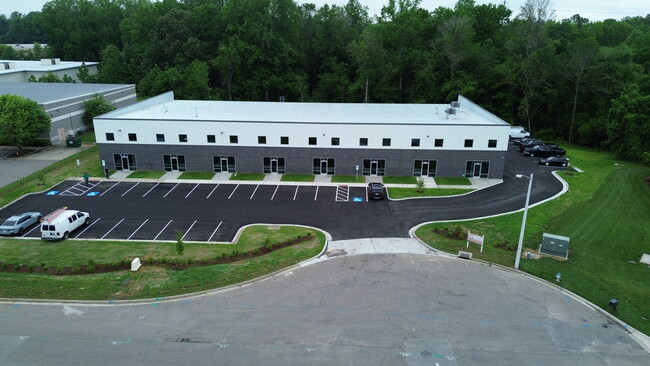
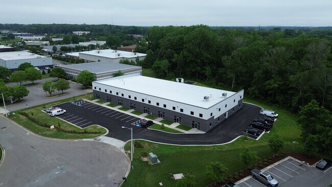
Property Record
405 Network Sta, Chesapeake, VA 23320


Property Detail
405 Network Sta
0482010000250
LT 25 OAKBROOKE BUSINESS & TECH CENTER PH 5 1.953
Commercialacreage
CHESAPEAKE
PUD: PLANN
Virginia
C and X Area of minimal flood hazard, usually depicted on FIRMs as above the 500-year flood level.
1.95 AC
2024
Bainbridge
2025
Hampton Roads
020805
Virginia Beach-Chesapeake-Norfolk, VA-NC
NEARBY LISTINGS FOR SALE OR LEASE
DEMOGRAPHICS near 405 Network Sta
1 mile
3 mile
5 mile
2025 Total Population
4,537
65,781
152,811
2030 Population
4,688
66,541
153,838
Pop Growth 2025-2030
+ 3.33%
+ 1.16%
+ 0.67%
Average Age
40
41
40
2025 Total Households
1,683
25,022
57,320
HH Growth 2025-2030
+ 3.21%
+ 1.23%
+ 0.75%
Median Household Inc
$96,007
$102,201
$100,184
Avg Household Size
2.60
2.50
2.60
2025 Avg HH Vehicles
2.00
2.00
2.00
Median Home Value
$436,184
$410,763
$394,596
Median Year Built
2010
1991
1990
Nearby Places
Map Layers
Map Styles
 Street
 Aerial
Transit
 Traffic
 Biking
Places
Listings with unknown addresses are not visible on the map
- Restaurants
- Banks
- Shops
- Fitness
- Groceries
PUBLIC TRANSPORTATION
AIRPORT
Norfolk International
Drive
Walk
Distance
Norfolk International
27 min
15.4 mi
Newport News/Williamsburg International
Drive
Walk
Distance
Newport News/Williamsburg International
60 min
39.5 mi
Freight Ports
Virginia Port Authority - Portsmouth
Drive
Walk
Distance
Virginia Port Authority - Portsmouth
28 min
15.3 mi
SALE & LEASE HISTORY
LISTING DATE
SALE/LEASE

Jul 09, 2024
For Lease
Nearby Properties
Address
Land Use
TOTAL SIZE
Lot Size
Zoning
Address
Land Use
TOTAL SIZE
Lot Size
Zoning
470,098 SF
14.10 AC
O-I: OFFIC
Address
Land Use
TOTAL SIZE
Lot Size
Zoning
141,461 SF
169.22 AC
C1: CONSER
Address
Land Use
TOTAL SIZE
Lot Size
Zoning
299,727 SF
170.79 AC
C1: CONSER
Address
Land Use
TOTAL SIZE
Lot Size
Zoning
154,540 SF
1.68 AC
O-I: OFFIC
Address
Land Use
TOTAL SIZE
Lot Size
Zoning
209,403 SF
2.81 AC
PUD: PLANN
Address
Land Use
TOTAL SIZE
Lot Size
Zoning
95,354 SF
39.53 AC
B2: GENERA
Address
Land Use
TOTAL SIZE
Lot Size
Zoning
145,522 SF
15.51 AC
PUD: PLANN
Address
Land Use
TOTAL SIZE
Lot Size
Zoning
286,936 SF
15 AC
RMF1: MULT
Address
Land Use
TOTAL SIZE
Lot Size
Zoning
218,812 SF
45.15 AC
PUD: PLANN
Address
Land Use
TOTAL SIZE
Lot Size
Zoning
140,369 SF
10.35 AC
PUD: PLANN
Address
Land Use
TOTAL SIZE
Lot Size
Zoning
26.63 AC
Address
Land Use
TOTAL SIZE
Lot Size
Zoning
270,962 SF
6.17 AC
MXD-U: MIX
Address
Land Use
TOTAL SIZE
Lot Size
Zoning
277,846 SF
12.50 AC
RMF1: MULT
Address
Land Use
TOTAL SIZE
Lot Size
Zoning
16.03 AC
A24
Address
Land Use
TOTAL SIZE
Lot Size
Zoning
75,936 SF
11.13 AC
MULTI: MUL
Address
Land Use
TOTAL SIZE
Lot Size
Zoning
188,683 SF
13.14 AC
O-I: OFFIC
Address
Land Use
TOTAL SIZE
Lot Size
Zoning
162,291 SF
2.98 AC
PUD: PLANN
Address
Land Use
TOTAL SIZE
Lot Size
Zoning
256,041 SF
12.32 AC
RMF1: MULT
Address
Land Use
TOTAL SIZE
Lot Size
Zoning
166,753 SF
1.46 AC
PUD: PLANN
Address
Land Use
TOTAL SIZE
Lot Size
Zoning
422.43 AC
PUD: PLANN
Address
Land Use
TOTAL SIZE
Lot Size
Zoning
196,905 SF
46.84 AC
R15S: RESI
Address
Land Use
TOTAL SIZE
Lot Size
Zoning
67,508 SF
16.63 AC
O-I: OFFIC
Address
Land Use
TOTAL SIZE
Lot Size
Zoning
19,962 SF
52.38 AC
PUD: PLANN
Address
Land Use
TOTAL SIZE
Lot Size
Zoning
152,650 SF
5.53 AC
O-I: OFFIC
Address
Land Use
TOTAL SIZE
Lot Size
Zoning
49,720 SF
27.37 AC
B2: GENERA
Address
Land Use
TOTAL SIZE
Lot Size
Zoning
175,028 SF
12.41 AC
RMF1: MULT
Address
Land Use
TOTAL SIZE
Lot Size
Zoning
115,568 SF
6.83 AC
PUD: PLANN
Address
Land Use
TOTAL SIZE
Lot Size
Zoning
1,188 SF
73.88 AC
A1: AGRICU
Address
Land Use
TOTAL SIZE
Lot Size
Zoning
190,194 SF
12.40 AC
RMF1: MULT
Address
Land Use
TOTAL SIZE
Lot Size
Zoning
50,416 SF
13.30 AC
RMF1: MULT
The World's #1 Commercial Real Estate Marketplace
Connect with us
© 2026 CoStar Group
The information above has been obtained from sources believed reliable. While we do not doubt its accuracy we have not verified it and make no guarantee, warranty or representation about it. It is your responsibility to independently confirm its accuracy and completeness. Any projections, opinions, assumptions, or estimates used are for example only and do not represent the current or future performance of the property. The value of this transaction to you depends on tax and other factors which should be evaluated by your tax, financial, and legal advisors. You and your advisors should conduct a careful, independent investigation of the property to determine to your satisfaction the suitability of the property for your needs.