Property Record
405 School Rd, Denver, PA 17517


NEARBY LISTINGS FOR SALE OR LEASE
-
-
View all Denver listings for lease on LoopNet.com
Property Detail
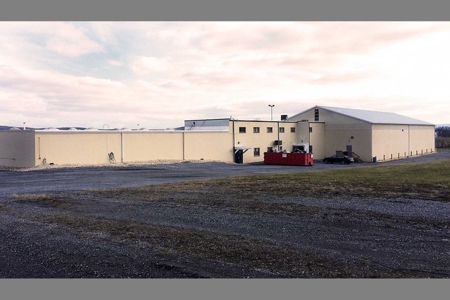
405 School Rd
Heavyindustrial
Lancaster
X
Pennsylvania
42071C0210F
26.70 AC
2024
Lancaster County
2025
Philadelphia
012601
Lancaster, PA
62,845 SF
040-84494-0-0000
DEMOGRAPHICS near 405 School Rd
1 Mile
3 Mile
5 Mile
2024 Total Population
2,028
10,007
26,587
2029 Population
2,035
9,947
26,461
Pop Growth 2024-2029
+ 0.35%
(0.60%)
(0.47%)
Average Age
41
39
40
2024 Total Households
721
3,382
9,319
HH Growth 2024-2029
+ 0.42%
(0.68%)
(0.54%)
Median Household Inc
$98,190
$86,489
$91,557
Avg Household Size
2.80
2.90
2.80
2024 Avg HH Vehicles
3.00
2.00
2.00
Median Home Value
$286,888
$267,995
$270,619
Median Year Built
1985
1979
1979
Nearby Places
Map Layers
Map Styles
 Street
 Aerial
- Restaurants
- Banks
- Shops
- Fitness
- Groceries
SALE & LEASE HISTORY
LISTING DATE
SALE/LEASE

Feb 07, 2017
For Lease
Nearby Properties
Address
Land Use
TOTAL SIZE
Lot Size
Zoning
Address
Land Use
TOTAL SIZE
Lot Size
Zoning
1,588,498 SF
150.55 AC
I-1
Address
Land Use
TOTAL SIZE
Lot Size
Zoning
170,735 SF
18.76 AC
Address
Land Use
TOTAL SIZE
Lot Size
Zoning
117,000 SF
12.98 AC
I-1
Address
Land Use
TOTAL SIZE
Lot Size
Zoning
73,417 SF
15.70 AC
RL
Address
Land Use
TOTAL SIZE
Lot Size
Zoning
270,732 SF
9.50 AC
I-1
Address
Land Use
TOTAL SIZE
Lot Size
Zoning
98,846 SF
32.95 AC
Address
Land Use
TOTAL SIZE
Lot Size
Zoning
61,835 SF
10.51 AC
LI
Address
Land Use
TOTAL SIZE
Lot Size
Zoning
51,898 SF
142 AC
A
Address
Land Use
TOTAL SIZE
Lot Size
Zoning
61,373 SF
5.77 AC
NC
Address
Land Use
TOTAL SIZE
Lot Size
Zoning
68,000 SF
8.10 AC
I-1
Address
Land Use
TOTAL SIZE
Lot Size
Zoning
16,640 SF
9.90 AC
Address
Land Use
TOTAL SIZE
Lot Size
Zoning
10,399 SF
107.90 AC
AG
Address
Land Use
TOTAL SIZE
Lot Size
Zoning
68,496 SF
28 AC
IL
Address
Land Use
TOTAL SIZE
Lot Size
Zoning
70,188 SF
5.40 AC
I-1
Address
Land Use
TOTAL SIZE
Lot Size
Zoning
23,368 SF
62.05 AC
AG
Address
Land Use
TOTAL SIZE
Lot Size
Zoning
9,244 SF
206.10 AC
Address
Land Use
TOTAL SIZE
Lot Size
Zoning
21,286 SF
88.30 AC
AG
Address
Land Use
TOTAL SIZE
Lot Size
Zoning
41,906 SF
8.80 AC
LI
Address
Land Use
TOTAL SIZE
Lot Size
Zoning
12,109 SF
6.20 AC
RM
Address
Land Use
TOTAL SIZE
Lot Size
Zoning
9,818 SF
5.20 AC
RL
Address
Land Use
TOTAL SIZE
Lot Size
Zoning
26,152 SF
14.80 AC
Address
Land Use
TOTAL SIZE
Lot Size
Zoning
56,400 SF
12.06 AC
Address
Land Use
TOTAL SIZE
Lot Size
Zoning
7,678 SF
86.09 AC
AG
Address
Land Use
TOTAL SIZE
Lot Size
Zoning
3,312 SF
90.24 AC
AG
Address
Land Use
TOTAL SIZE
Lot Size
Zoning
6,624 SF
103.60 AC
AG
Address
Land Use
TOTAL SIZE
Lot Size
Zoning
5,430 SF
106.50 AC
AG
Address
Land Use
TOTAL SIZE
Lot Size
Zoning
7,647 SF
88.09 AC
AG
Address
Land Use
TOTAL SIZE
Lot Size
Zoning
38,260 SF
4.30 AC
I1
Address
Land Use
TOTAL SIZE
Lot Size
Zoning
9,260 SF
78.30 AC
AG
Address
Land Use
TOTAL SIZE
Lot Size
Zoning
15,566 SF
10.60 AC
AG
The World's #1 Commercial Real Estate Marketplace
Connect with us
© 2025 CoStar Group
The information above has been obtained from sources believed reliable. While we do not doubt its accuracy we have not verified it and make no guarantee, warranty or representation about it. It is your responsibility to independently confirm its accuracy and completeness. Any projections, opinions, assumptions, or estimates used are for example only and do not represent the current or future performance of the property. The value of this transaction to you depends on tax and other factors which should be evaluated by your tax, financial, and legal advisors. You and your advisors should conduct a careful, independent investigation of the property to determine to your satisfaction the suitability of the property for your needs.