Property Record
405 Shell Rd, Penns Grove, NJ 08069

Property Detail
405 Shell Rd
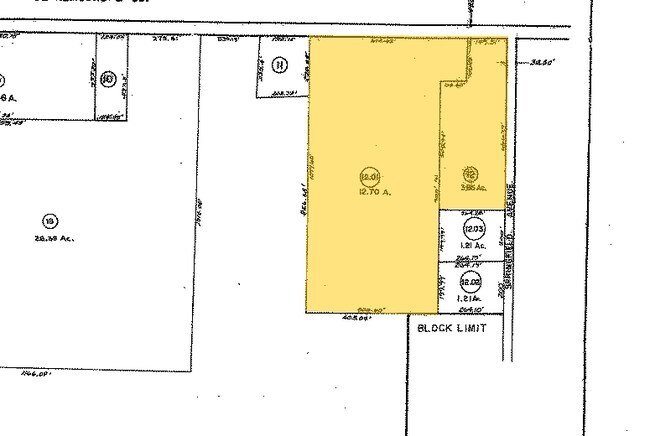
02-00193-0000-00012-01
INCL BLK 193 P/O LOT 12
Vacantlandnec
SALEM
LI
New Jersey
C and X Area of minimal flood hazard, usually depicted on FIRMs as above the 500-year flood level.
12
2024
12.70 AC
2025
Salem County
020600
Philadelphia
1,332 SF
Philadelphia-Camden-Wilmington, PA-NJ-DE-MD
NEARBY LISTINGS FOR SALE OR LEASE
DEMOGRAPHICS near 405 Shell Rd
1 mile
3 mile
5 mile
2025 Total Population
2,725
15,972
69,534
2030 Population
2,789
16,371
71,651
Pop Growth 2025-2030
+ 2.35%
+ 2.50%
+ 3.04%
Average Age
42
40
40
2025 Total Households
1,062
6,148
27,200
HH Growth 2025-2030
+ 2.45%
+ 2.44%
+ 3.08%
Median Household Inc
$84,745
$74,713
$66,403
Avg Household Size
2.50
2.50
2.40
2025 Avg HH Vehicles
2.00
2.00
2.00
Median Home Value
$181,190
$216,326
$211,878
Median Year Built
1956
1958
1957
Nearby Places
Map Layers
Map Styles
 Street
 Aerial
Layers
 Traffic
 Biking
Places
Listings with unknown addresses are not visible on the map
- Restaurants
- Banks
- Shops
- Fitness
- Groceries
PUBLIC TRANSPORTATION
COMMUTER RAIL
Wilmington (R2 - Southeastern Pennsylvania Transportation Authority Regional Rail (SEPTA Regional Rail))
Drive
Walk
Distance
Wilmington (R2 - Southeastern Pennsylvania Transportation Authority Regional Rail (SEPTA Regional Rail))
16 min
8.1 mi
AIRPORT
Philadelphia International
Drive
Walk
Distance
Philadelphia International
36 min
23.0 mi
Freight Ports
Port of Wilmington, RI
Drive
Walk
Distance
Port of Wilmington, RI
16 min
8.1 mi
SALE & LEASE HISTORY
LISTING DATE
SALE/LEASE

Jul 18, 2017
For Sale
Nearby Properties
Address
Land Use
TOTAL SIZE
Lot Size
Zoning
Address
Land Use
TOTAL SIZE
Lot Size
Zoning
118.77 AC
GC
Address
Land Use
TOTAL SIZE
Lot Size
Zoning
412.70 AC
06
Address
Land Use
TOTAL SIZE
Lot Size
Zoning
150.60 AC
AG
Address
Land Use
TOTAL SIZE
Lot Size
Zoning
47.91 AC
IC
Address
Land Use
TOTAL SIZE
Lot Size
Zoning
Address
Land Use
TOTAL SIZE
Lot Size
Zoning
10.75 AC
LC
Address
Land Use
TOTAL SIZE
Lot Size
Zoning
118.77 AC
GC
Address
Land Use
TOTAL SIZE
Lot Size
Zoning
29.05 AC
GC
Address
Land Use
TOTAL SIZE
Lot Size
Zoning
23,402 SF
44.89 AC
LR
Address
Land Use
TOTAL SIZE
Lot Size
Zoning
250.90 AC
26M-1
Address
Land Use
TOTAL SIZE
Lot Size
Zoning
1,152 SF
27 AC
26M-2
Address
Land Use
TOTAL SIZE
Lot Size
Zoning
26.64 AC
GI
Address
Land Use
TOTAL SIZE
Lot Size
Zoning
150.60 AC
AG
Address
Land Use
TOTAL SIZE
Lot Size
Zoning
47.91 AC
IC
Address
Land Use
TOTAL SIZE
Lot Size
Zoning
141.30 AC
HI
Address
Land Use
TOTAL SIZE
Lot Size
Zoning
101.53 AC
26M-2
Address
Land Use
TOTAL SIZE
Lot Size
Zoning
10.28 AC
IC
Address
Land Use
TOTAL SIZE
Lot Size
Zoning
848 SF
10.69 AC
LR
Address
Land Use
TOTAL SIZE
Lot Size
Zoning
29.05 AC
GC
Address
Land Use
TOTAL SIZE
Lot Size
Zoning
1,133.55 AC
GI
Address
Land Use
TOTAL SIZE
Lot Size
Zoning
19.67 AC
LR
Address
Land Use
TOTAL SIZE
Lot Size
Zoning
76,331 SF
52.52 AC
HI
Address
Land Use
TOTAL SIZE
Lot Size
Zoning
87.65 AC
26M-1
Address
Land Use
TOTAL SIZE
Lot Size
Zoning
78.86 AC
26M-2
Address
Land Use
TOTAL SIZE
Lot Size
Zoning
11.76 AC
GC
Address
Land Use
TOTAL SIZE
Lot Size
Zoning
2,016 SF
1.44 AC
02
Address
Land Use
TOTAL SIZE
Lot Size
Zoning
Address
Land Use
TOTAL SIZE
Lot Size
Zoning
31.77 AC
GC
Address
Land Use
TOTAL SIZE
Lot Size
Zoning
19,576 SF
5.70 AC
Address
Land Use
TOTAL SIZE
Lot Size
Zoning
The World's #1 Commercial Real Estate Marketplace
Connect with us
© 2026 CoStar Group
The information above has been obtained from sources believed reliable. While we do not doubt its accuracy we have not verified it and make no guarantee, warranty or representation about it. It is your responsibility to independently confirm its accuracy and completeness. Any projections, opinions, assumptions, or estimates used are for example only and do not represent the current or future performance of the property. The value of this transaction to you depends on tax and other factors which should be evaluated by your tax, financial, and legal advisors. You and your advisors should conduct a careful, independent investigation of the property to determine to your satisfaction the suitability of the property for your needs.