Property Record
4050 Highway 60 W, Faribault, MN 55021
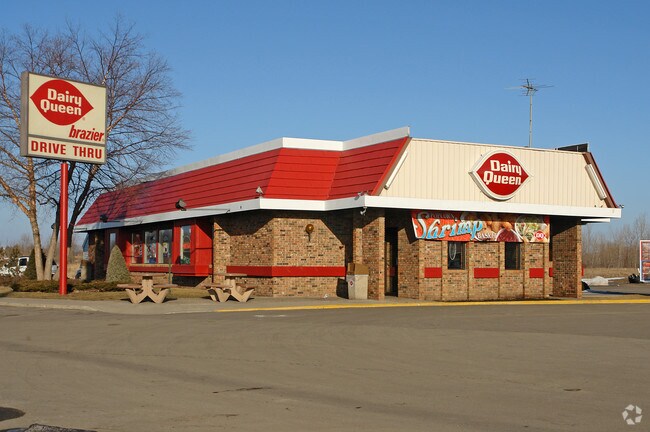

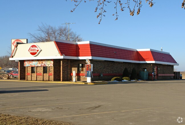
Property Detail
4050 Highway 60 W
18.35.1.50.010
PART SW4 NE4 BEG SW COR SW4 NE4 TH NLY ALG W LI SW4 NE4 6.55FT TAP NWLY R/W LI HWY 60 TH N60D07'46E 391.45FT TH N2D12'28W
Restaurantdrivein
Rice
B and X Area of moderate flood hazard, usually the area between the limits of the 100-year and 500-year floods.
Minnesota
2025
1.20 AC
2025
Minnesota South Area
070400
Other Market Areas
3,440 SF
Faribault-Northfield, MN
NEARBY LISTINGS FOR SALE OR LEASE
DEMOGRAPHICS near 4050 Highway 60 W
1 mile
3 mile
5 mile
2025 Total Population
575
20,924
28,387
2030 Population
597
21,359
29,010
Pop Growth 2025-2030
+ 3.83%
+ 2.08%
+ 2.19%
Average Age
39
39
40
2025 Total Households
223
8,004
10,208
HH Growth 2025-2030
+ 4.04%
+ 2.40%
+ 2.45%
Median Household Inc
$67,874
$56,980
$62,048
Avg Household Size
2.50
2.50
2.50
2025 Avg HH Vehicles
2.00
2.00
2.00
Median Home Value
$215,909
$239,643
$256,381
Median Year Built
1976
1972
1974
Nearby Places
Map Layers
Map Styles
 Street
 Aerial
Layers
 Traffic
 Biking
Places
Listings with unknown addresses are not visible on the map
- Restaurants
- Banks
- Shops
- Fitness
- Groceries
Nearby Properties
Address
Land Use
TOTAL SIZE
Lot Size
Zoning
Address
Land Use
TOTAL SIZE
Lot Size
Zoning
41,009 SF
131 AC
Address
Land Use
TOTAL SIZE
Lot Size
Zoning
915 SF
44.17 AC
Address
Land Use
TOTAL SIZE
Lot Size
Zoning
20.90 AC
Address
Land Use
TOTAL SIZE
Lot Size
Zoning
19,382 SF
11.59 AC
Address
Land Use
TOTAL SIZE
Lot Size
Zoning
19,763 SF
28 AC
Address
Land Use
TOTAL SIZE
Lot Size
Zoning
80,763 SF
26.50 AC
Address
Land Use
TOTAL SIZE
Lot Size
Zoning
66,089 SF
73.90 AC
Address
Land Use
TOTAL SIZE
Lot Size
Zoning
15,000 SF
20.04 AC
Address
Land Use
TOTAL SIZE
Lot Size
Zoning
6,539 SF
27.70 AC
Address
Land Use
TOTAL SIZE
Lot Size
Zoning
30,100 SF
2.86 AC
Address
Land Use
TOTAL SIZE
Lot Size
Zoning
6,512 SF
19.50 AC
Address
Land Use
TOTAL SIZE
Lot Size
Zoning
608 SF
34.30 AC
Address
Land Use
TOTAL SIZE
Lot Size
Zoning
29,204 SF
3.50 AC
Address
Land Use
TOTAL SIZE
Lot Size
Zoning
7,830 SF
2.50 AC
Address
Land Use
TOTAL SIZE
Lot Size
Zoning
39,754 SF
7.40 AC
Address
Land Use
TOTAL SIZE
Lot Size
Zoning
974 SF
7.95 AC
Address
Land Use
TOTAL SIZE
Lot Size
Zoning
89,612 SF
16.73 AC
Address
Land Use
TOTAL SIZE
Lot Size
Zoning
7,465 SF
29 AC
Address
Land Use
TOTAL SIZE
Lot Size
Zoning
4,985 SF
17.32 AC
Address
Land Use
TOTAL SIZE
Lot Size
Zoning
29,872 SF
4.58 AC
Address
Land Use
TOTAL SIZE
Lot Size
Zoning
9,490 SF
1.93 AC
Address
Land Use
TOTAL SIZE
Lot Size
Zoning
23,072 SF
2.11 AC
Address
Land Use
TOTAL SIZE
Lot Size
Zoning
15,076 SF
3.60 AC
Address
Land Use
TOTAL SIZE
Lot Size
Zoning
15,076 SF
5.10 AC
Address
Land Use
TOTAL SIZE
Lot Size
Zoning
82,428 SF
23.67 AC
Address
Land Use
TOTAL SIZE
Lot Size
Zoning
12,265 SF
4.03 AC
Address
Land Use
TOTAL SIZE
Lot Size
Zoning
13,433 SF
2.50 AC
Address
Land Use
TOTAL SIZE
Lot Size
Zoning
144 SF
1.60 AC
Address
Land Use
TOTAL SIZE
Lot Size
Zoning
31,697 SF
3.60 AC
Address
Land Use
TOTAL SIZE
Lot Size
Zoning
3,620 SF
14.56 AC
The World's #1 Commercial Real Estate Marketplace
Connect with us
© 2026 CoStar Group
The information above has been obtained from sources believed reliable. While we do not doubt its accuracy we have not verified it and make no guarantee, warranty or representation about it. It is your responsibility to independently confirm its accuracy and completeness. Any projections, opinions, assumptions, or estimates used are for example only and do not represent the current or future performance of the property. The value of this transaction to you depends on tax and other factors which should be evaluated by your tax, financial, and legal advisors. You and your advisors should conduct a careful, independent investigation of the property to determine to your satisfaction the suitability of the property for your needs.