Property Record
4050 N Buffalo St, Orchard Park, NY 14127

NEARBY LISTINGS FOR SALE OR LEASE
Property Detail
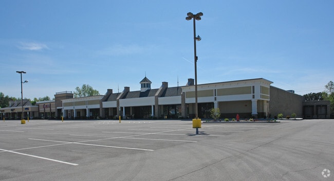
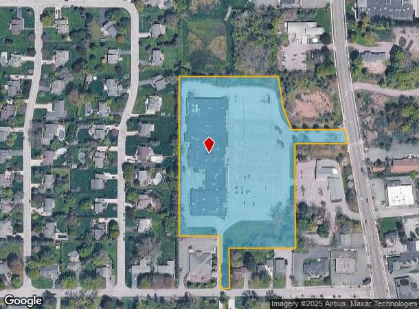
4050 N Buffalo St
Buffalo-Cheektowaga-Niagara Falls, NY
The Holland Land Companys Survey
146089-161-160-0001-013-311
PARCEL B NEW TAYLOR RD 7.95AC+
Stripcommercialcenter
Erie
X
New York
36029C0363H
13.311
2025
7.95 AC
2024
South
013701
Buffalo/Niagara Falls
69,207 SF
DEMOGRAPHICS near 4050 N Buffalo St
1 Mile
3 Mile
5 Mile
2024 Total Population
4,553
34,598
96,899
2029 Population
4,550
34,629
96,725
Pop Growth 2024-2029
(0.07%)
+ 0.09%
(0.18%)
Average Age
44
44
44
2024 Total Households
1,940
14,276
41,431
HH Growth 2024-2029
(0.15%)
+ 0.06%
(0.25%)
Median Household Inc
$91,666
$85,538
$73,941
Avg Household Size
2.30
2.40
2.30
2024 Avg HH Vehicles
2.00
2.00
2.00
Median Home Value
$287,051
$277,008
$225,794
Median Year Built
1971
1977
1969
Nearby Places
- Restaurants
- Banks
- Shops
- Fitness
- Groceries
PUBLIC TRANSPORTATION
AIRPORT
Buffalo Niagara International
DRIVE
WALK
Distance
Buffalo Niagara International
28 min
18.0 mi
Niagara Falls International
DRIVE
WALK
Distance
Niagara Falls International
49 min
31.1 mi
Freight Ports
Port of Toledo
DRIVE
WALK
Distance
Port of Toledo
354 min
299.0 mi
SALE & LEASE HISTORY
LISTING DATE
SALE/LEASE

Sep 25, 2016
For Lease
Nearby Properties
Address
Land Use
TOTAL SIZE
Lot Size
Zoning
Address
Land Use
TOTAL SIZE
Lot Size
Zoning
49,500 SF
108.40 AC
R1
Address
Land Use
TOTAL SIZE
Lot Size
Zoning
22,754 SF
41.80 AC
Address
Land Use
TOTAL SIZE
Lot Size
Zoning
183,334 SF
50.90 AC
B2
Address
Land Use
TOTAL SIZE
Lot Size
Zoning
197,584 SF
32.50 AC
B2
Address
Land Use
TOTAL SIZE
Lot Size
Zoning
115,317 SF
17.87 AC
DR
Address
Land Use
TOTAL SIZE
Lot Size
Zoning
124,112 SF
53.10 AC
05 - COMME
Address
Land Use
TOTAL SIZE
Lot Size
Zoning
149,065 SF
21.53 AC
B2
Address
Land Use
TOTAL SIZE
Lot Size
Zoning
59,421 SF
75.40 AC
B1
Address
Land Use
TOTAL SIZE
Lot Size
Zoning
202,597 SF
24.22 AC
Address
Land Use
TOTAL SIZE
Lot Size
Zoning
97,709 SF
14.13 AC
R2
Address
Land Use
TOTAL SIZE
Lot Size
Zoning
71,654 SF
24.35 AC
R2
Address
Land Use
TOTAL SIZE
Lot Size
Zoning
8,320 SF
22.10 AC
Address
Land Use
TOTAL SIZE
Lot Size
Zoning
13,062 SF
26.07 AC
R4
Address
Land Use
TOTAL SIZE
Lot Size
Zoning
235,940 SF
62.47 AC
R2
Address
Land Use
TOTAL SIZE
Lot Size
Zoning
3,361 SF
28.04 AC
R3
Address
Land Use
TOTAL SIZE
Lot Size
Zoning
143,400 SF
11.33 AC
B1
Address
Land Use
TOTAL SIZE
Lot Size
Zoning
87,835 SF
21.86 AC
Address
Land Use
TOTAL SIZE
Lot Size
Zoning
134,680 SF
16.47 AC
B2
Address
Land Use
TOTAL SIZE
Lot Size
Zoning
53,511 SF
5.01 AC
B1
Address
Land Use
TOTAL SIZE
Lot Size
Zoning
73,137 SF
R2
Address
Land Use
TOTAL SIZE
Lot Size
Zoning
89,371 SF
17.87 AC
R2
Address
Land Use
TOTAL SIZE
Lot Size
Zoning
82,954 SF
25.50 AC
Address
Land Use
TOTAL SIZE
Lot Size
Zoning
Address
Land Use
TOTAL SIZE
Lot Size
Zoning
284,403 SF
27.29 AC
I1
Address
Land Use
TOTAL SIZE
Lot Size
Zoning
9,322 SF
4.70 AC
B2
Address
Land Use
TOTAL SIZE
Lot Size
Zoning
118,891 SF
8.99 AC
I1
Address
Land Use
TOTAL SIZE
Lot Size
Zoning
Address
Land Use
TOTAL SIZE
Lot Size
Zoning
51,646 SF
16.87 AC
R2
Address
Land Use
TOTAL SIZE
Lot Size
Zoning
82,348 SF
6.49 AC
SR
Address
Land Use
TOTAL SIZE
Lot Size
Zoning
27,340 SF
21.18 AC
B2
The World's #1 Commercial Real Estate Marketplace
Connect with us
© 2025 CoStar Group
The information above has been obtained from sources believed reliable. While we do not doubt its accuracy we have not verified it and make no guarantee, warranty or representation about it. It is your responsibility to independently confirm its accuracy and completeness. Any projections, opinions, assumptions, or estimates used are for example only and do not represent the current or future performance of the property. The value of this transaction to you depends on tax and other factors which should be evaluated by your tax, financial, and legal advisors. You and your advisors should conduct a careful, independent investigation of the property to determine to your satisfaction the suitability of the property for your needs.