Property Record
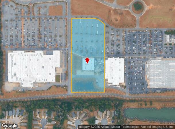
4051 Lagniappe Way, Tallahassee, FL 32317

NEARBY LISTINGS FOR SALE OR LEASE
Property Detail
4051 Lagniappe Way
Tallahassee, FL
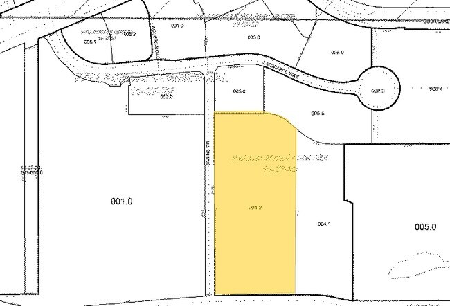
Fallschase Center
11-27-30-000-004.2
FALLSCHASE CENTER IN SEC 22 & 27 LOT 4.2
Regionalshoppingcenterormallwithanchorstore
Leon
X
Florida
12073C0304F
4
2025
7.69 AC
2025
Southeast Leon County
002505
Tallahassee
19,740 SF
DEMOGRAPHICS near 4051 Lagniappe Way
1 Mile
3 Mile
5 Mile
2024 Total Population
4,632
48,631
120,084
2029 Population
4,883
51,520
126,912
Pop Growth 2024-2029
+ 5.42%
+ 5.94%
+ 5.69%
Average Age
40
40
39
2024 Total Households
2,024
21,987
53,817
HH Growth 2024-2029
+ 5.98%
+ 6.18%
+ 5.95%
Median Household Inc
$67,768
$67,581
$63,787
Avg Household Size
2.10
2.10
2.10
2024 Avg HH Vehicles
2.00
2.00
2.00
Median Home Value
$256,680
$256,223
$277,857
Median Year Built
1997
1990
1986
Nearby Places
Map Layers
Map Styles
 Street
 Aerial
- Restaurants
- Banks
- Shops
- Fitness
- Groceries
PUBLIC TRANSPORTATION
AIRPORT
Tallahassee International
DRIVE
WALK
Distance
Tallahassee International
28 min
11.5 mi
SALE & LEASE HISTORY
LISTING DATE
SALE/LEASE

Sep 25, 2016
For Lease
Mar 02, 2018
For Sale
Nearby Properties
Address
Land Use
TOTAL SIZE
Lot Size
Zoning
Address
Land Use
TOTAL SIZE
Lot Size
Zoning
3,882,850 SF
22.64 AC
CM
Address
Land Use
TOTAL SIZE
Lot Size
Zoning
1,906,594 SF
112.75 AC
PUD
Address
Land Use
TOTAL SIZE
Lot Size
Zoning
361,804 SF
14.17 AC
CM
Address
Land Use
TOTAL SIZE
Lot Size
Zoning
577,345 SF
30.63 AC
Address
Land Use
TOTAL SIZE
Lot Size
Zoning
846,072 SF
166.39 AC
R1
Address
Land Use
TOTAL SIZE
Lot Size
Zoning
545,485 SF
14.01 AC
Address
Land Use
TOTAL SIZE
Lot Size
Zoning
756,294 SF
20.19 AC
OR3
Address
Land Use
TOTAL SIZE
Lot Size
Zoning
456,149 SF
22.50 AC
OR3
Address
Land Use
TOTAL SIZE
Lot Size
Zoning
775,087 SF
18.34 AC
Address
Land Use
TOTAL SIZE
Lot Size
Zoning
708,504 SF
50.44 AC
PUD
Address
Land Use
TOTAL SIZE
Lot Size
Zoning
380,000 SF
21.78 AC
PUD
Address
Land Use
TOTAL SIZE
Lot Size
Zoning
473,339 SF
51.93 AC
PUD
Address
Land Use
TOTAL SIZE
Lot Size
Zoning
543,726 SF
13.13 AC
PUD
Address
Land Use
TOTAL SIZE
Lot Size
Zoning
338,790 SF
16 AC
PUD
Address
Land Use
TOTAL SIZE
Lot Size
Zoning
338,619 SF
107.89 AC
GO1
Address
Land Use
TOTAL SIZE
Lot Size
Zoning
606,101 SF
19.01 AC
MR1
Address
Land Use
TOTAL SIZE
Lot Size
Zoning
312,935 SF
11.74 AC
MR1
Address
Land Use
TOTAL SIZE
Lot Size
Zoning
312,935 SF
12.82 AC
MR1
Address
Land Use
TOTAL SIZE
Lot Size
Zoning
456,212 SF
117.40 AC
MR1
Address
Land Use
TOTAL SIZE
Lot Size
Zoning
312,392 SF
14.52 AC
MR1
Address
Land Use
TOTAL SIZE
Lot Size
Zoning
534,652 SF
57.35 AC
MR1
Address
Land Use
TOTAL SIZE
Lot Size
Zoning
247,794 SF
17.24 AC
CP
Address
Land Use
TOTAL SIZE
Lot Size
Zoning
196,912 SF
17.25 AC
CP
Address
Land Use
TOTAL SIZE
Lot Size
Zoning
449,952 SF
13.18 AC
AC
Address
Land Use
TOTAL SIZE
Lot Size
Zoning
131,893 SF
11.01 AC
PUD
Address
Land Use
TOTAL SIZE
Lot Size
Zoning
605,124 SF
15.72 AC
AC
Address
Land Use
TOTAL SIZE
Lot Size
Zoning
280,738 SF
13.10 AC
TPA
Address
Land Use
TOTAL SIZE
Lot Size
Zoning
257,119 SF
36.46 AC
CPA
Address
Land Use
TOTAL SIZE
Lot Size
Zoning
145,652 SF
7.89 AC
M1
Address
Land Use
TOTAL SIZE
Lot Size
Zoning
319,584 SF
14.67 AC
PUD
The World's #1 Commercial Real Estate Marketplace
Connect with us
© 2025 CoStar Group
The information above has been obtained from sources believed reliable. While we do not doubt its accuracy we have not verified it and make no guarantee, warranty or representation about it. It is your responsibility to independently confirm its accuracy and completeness. Any projections, opinions, assumptions, or estimates used are for example only and do not represent the current or future performance of the property. The value of this transaction to you depends on tax and other factors which should be evaluated by your tax, financial, and legal advisors. You and your advisors should conduct a careful, independent investigation of the property to determine to your satisfaction the suitability of the property for your needs.