Property Record
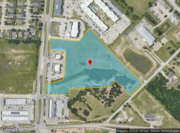
4051 S Belt Line Rd, Mesquite, TX 75181

NEARBY LISTINGS FOR SALE OR LEASE
Property Detail
4051 S Belt Line Rd
Dallas-Fort Worth-Arlington, TX
Robert Kleberg
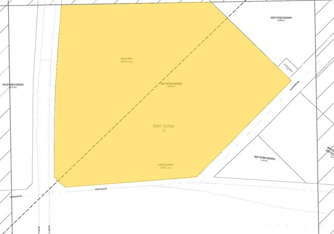
65071678610290300
ROBERT KLEBERG ABST 716 PG 786 TR 29.3 ACS 9.735 ALSO LOC ON ABST 1374 INT201500264532 DD09302015 CDC 0716786102903 3CB07167861
Commercialacreage
Dallas
X
Texas
48257C0150E
29
0
9.74 AC
2025
Mesquite/Forney/Terrell
017315
Dallas/Ft Worth
2,434 SF
DEMOGRAPHICS near 4051 S Belt Line Rd
1 Mile
3 Mile
5 Mile
2024 Total Population
11,170
70,109
168,809
2029 Population
11,310
70,288
167,961
Pop Growth 2024-2029
+ 1.25%
+ 0.26%
(0.50%)
Average Age
32
33
34
2024 Total Households
3,130
20,115
48,612
HH Growth 2024-2029
+ 1.18%
+ 0.01%
(0.74%)
Median Household Inc
$51,455
$57,393
$58,114
Avg Household Size
3.50
3.40
3.30
2024 Avg HH Vehicles
2.00
2.00
2.00
Median Home Value
$139,847
$198,704
$184,819
Median Year Built
1997
1994
1986
Nearby Places
Map Layers
Map Styles
 Street
 Aerial
- Restaurants
- Banks
- Shops
- Fitness
- Groceries
PUBLIC TRANSPORTATION
AIRPORT
Dallas Love Field
DRIVE
WALK
Distance
Dallas Love Field
31 min
21.2 mi
Dallas-Fort Worth International
DRIVE
WALK
Distance
Dallas-Fort Worth International
47 min
37.1 mi
Freight Ports
Port of Shreveport
DRIVE
WALK
Distance
Port of Shreveport
195 min
182.6 mi
Nearby Properties
Address
Land Use
TOTAL SIZE
Lot Size
Zoning
Address
Land Use
TOTAL SIZE
Lot Size
Zoning
263,360 SF
42.98 AC
Z237
Address
Land Use
TOTAL SIZE
Lot Size
Zoning
441,799 SF
64.72 AC
Z05
Address
Land Use
TOTAL SIZE
Lot Size
Zoning
457,110 SF
100.05 AC
Z293
Address
Land Use
TOTAL SIZE
Lot Size
Zoning
200,000 SF
8.11 AC
Address
Land Use
TOTAL SIZE
Lot Size
Zoning
255,008 SF
30.39 AC
Z250
Address
Land Use
TOTAL SIZE
Lot Size
Zoning
290,916 SF
8.24 AC
Address
Land Use
TOTAL SIZE
Lot Size
Zoning
193,000 SF
34.42 AC
Z05
Address
Land Use
TOTAL SIZE
Lot Size
Zoning
257,696 SF
9.62 AC
Address
Land Use
TOTAL SIZE
Lot Size
Zoning
372,456 SF
17.34 AC
Z116
Address
Land Use
TOTAL SIZE
Lot Size
Zoning
364,000 SF
40.25 AC
Z236
Address
Land Use
TOTAL SIZE
Lot Size
Zoning
109,472 SF
6.98 AC
Address
Land Use
TOTAL SIZE
Lot Size
Zoning
148,776 SF
35.77 AC
Z237
Address
Land Use
TOTAL SIZE
Lot Size
Zoning
267,011 SF
11.11 AC
Z250
Address
Land Use
TOTAL SIZE
Lot Size
Zoning
400 SF
50.76 AC
MFA
Address
Land Use
TOTAL SIZE
Lot Size
Zoning
238,728 SF
12.31 AC
Z184
Address
Land Use
TOTAL SIZE
Lot Size
Zoning
234,459 SF
9.71 AC
Z138
Address
Land Use
TOTAL SIZE
Lot Size
Zoning
321 SF
40.51 AC
MFA
Address
Land Use
TOTAL SIZE
Lot Size
Zoning
91,871 SF
8.44 AC
Z05
Address
Land Use
TOTAL SIZE
Lot Size
Zoning
190,150 SF
13.39 AC
Z236
Address
Land Use
TOTAL SIZE
Lot Size
Zoning
215 SF
29.95 AC
A
Address
Land Use
TOTAL SIZE
Lot Size
Zoning
118,237 SF
5.56 AC
Z183
Address
Land Use
TOTAL SIZE
Lot Size
Zoning
123,790 SF
6.68 AC
Z183
Address
Land Use
TOTAL SIZE
Lot Size
Zoning
248 SF
32.79 AC
MFA
Address
Land Use
TOTAL SIZE
Lot Size
Zoning
160,000 SF
9.60 AC
Z250
Address
Land Use
TOTAL SIZE
Lot Size
Zoning
208 SF
24.50 AC
Z06
Address
Land Use
TOTAL SIZE
Lot Size
Zoning
122,352 SF
6.05 AC
Z46
Address
Land Use
TOTAL SIZE
Lot Size
Zoning
183 SF
23.14 AC
Z06
Address
Land Use
TOTAL SIZE
Lot Size
Zoning
31,129 SF
33.93 AC
Z05
Address
Land Use
TOTAL SIZE
Lot Size
Zoning
80,933 SF
7.96 AC
Z05
Address
Land Use
TOTAL SIZE
Lot Size
Zoning
70,000 SF
25.26 AC
Z06
The World's #1 Commercial Real Estate Marketplace
Connect with us
© 2025 CoStar Group
The information above has been obtained from sources believed reliable. While we do not doubt its accuracy we have not verified it and make no guarantee, warranty or representation about it. It is your responsibility to independently confirm its accuracy and completeness. Any projections, opinions, assumptions, or estimates used are for example only and do not represent the current or future performance of the property. The value of this transaction to you depends on tax and other factors which should be evaluated by your tax, financial, and legal advisors. You and your advisors should conduct a careful, independent investigation of the property to determine to your satisfaction the suitability of the property for your needs.