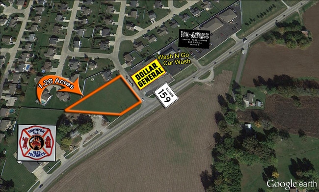
Property Record
4053 State Route 159, Smithton, IL 62285

NEARBY LISTINGS FOR SALE OR LEASE
-
-
View all Smithton listings for sale on LoopNet.com
Property Detail
4053 State Route 159
St. Louis
Manors Of Fieldstone
St. Louis, MO-IL
MANORS OF FIELDSTONE LOT 5 A01955956
13-28.0-409-008
St. Clair
Commercialnec
Illinois
2024
5
2024
1.23 AC
503906
Illinois
DEMOGRAPHICS near 4053 State Route 159
1 Mile
3 Mile
5 Mile
2024 Total Population
1,768
3,876
9,874
2029 Population
1,673
3,679
9,440
Pop Growth 2024-2029
(5.37%)
(5.08%)
(4.40%)
Average Age
42
43
43
2024 Total Households
721
1,533
3,893
HH Growth 2024-2029
(5.27%)
(5.02%)
(4.37%)
Median Household Inc
$100,426
$111,313
$104,898
Avg Household Size
2.50
2.50
2.50
2024 Avg HH Vehicles
2.00
3.00
2.00
Median Home Value
$208,996
$237,635
$238,844
Median Year Built
1987
1989
1990
Nearby Places
Map Layers
Map Styles
 Street
 Aerial
- Restaurants
- Banks
- Shops
- Fitness
- Groceries
PUBLIC TRANSPORTATION
COMMUTER RAIL
Belleville (Lambert Airport Shiloh-Scott - St. Louis MetroLink (MetroLink))
DRIVE
WALK
Distance
Belleville (Lambert Airport Shiloh-Scott - St. Louis MetroLink (MetroLink))
14 min
8.1 mi
Swansea (Lambert Airport Shiloh-Scott - St. Louis MetroLink (MetroLink))
DRIVE
WALK
Distance
Swansea (Lambert Airport Shiloh-Scott - St. Louis MetroLink (MetroLink))
15 min
8.8 mi
AIRPORT
Scott AFB/Midamerica St Louis
DRIVE
WALK
Distance
Scott AFB/Midamerica St Louis
32 min
17.4 mi
St Louis Lambert International
DRIVE
WALK
Distance
St Louis Lambert International
50 min
34.8 mi
SALE & LEASE HISTORY
LISTING DATE
SALE/LEASE

Sep 24, 2016
For Sale
Nearby Properties
Address
Land Use
TOTAL SIZE
Lot Size
Zoning
Address
Land Use
TOTAL SIZE
Lot Size
Zoning
1.09 AC
Address
Land Use
TOTAL SIZE
Lot Size
Zoning
8,192 SF
2.66 AC
Address
Land Use
TOTAL SIZE
Lot Size
Zoning
7,410 SF
0.85 AC
Address
Land Use
TOTAL SIZE
Lot Size
Zoning
9,000 SF
0.94 AC
Address
Land Use
TOTAL SIZE
Lot Size
Zoning
9,100 SF
0.83 AC
Address
Land Use
TOTAL SIZE
Lot Size
Zoning
3,015 SF
1.41 AC
Address
Land Use
TOTAL SIZE
Lot Size
Zoning
2,496 SF
1.11 AC
Address
Land Use
TOTAL SIZE
Lot Size
Zoning
11,834 SF
1.37 AC
Address
Land Use
TOTAL SIZE
Lot Size
Zoning
4,004 SF
0.34 AC
Address
Land Use
TOTAL SIZE
Lot Size
Zoning
3,563 SF
18.80 AC
Address
Land Use
TOTAL SIZE
Lot Size
Zoning
Address
Land Use
TOTAL SIZE
Lot Size
Zoning
1.69 AC
Address
Land Use
TOTAL SIZE
Lot Size
Zoning
1,812 SF
0.63 AC
Address
Land Use
TOTAL SIZE
Lot Size
Zoning
7,242 SF
0.92 AC
Address
Land Use
TOTAL SIZE
Lot Size
Zoning
21,150 SF
1.57 AC
Address
Land Use
TOTAL SIZE
Lot Size
Zoning
4,400 SF
1.18 AC
Address
Land Use
TOTAL SIZE
Lot Size
Zoning
1,296 SF
1.70 AC
Address
Land Use
TOTAL SIZE
Lot Size
Zoning
544 SF
0.84 AC
Address
Land Use
TOTAL SIZE
Lot Size
Zoning
6,500 SF
0.71 AC
Address
Land Use
TOTAL SIZE
Lot Size
Zoning
12,700 SF
0.29 AC
Address
Land Use
TOTAL SIZE
Lot Size
Zoning
9,480 SF
1.73 AC
Address
Land Use
TOTAL SIZE
Lot Size
Zoning
9,800 SF
1.19 AC
Address
Land Use
TOTAL SIZE
Lot Size
Zoning
12,451 SF
2.08 AC
Address
Land Use
TOTAL SIZE
Lot Size
Zoning
1.03 AC
Address
Land Use
TOTAL SIZE
Lot Size
Zoning
0.58 AC
Address
Land Use
TOTAL SIZE
Lot Size
Zoning
Address
Land Use
TOTAL SIZE
Lot Size
Zoning
2,000 SF
0.17 AC
Address
Land Use
TOTAL SIZE
Lot Size
Zoning
7,620 SF
2.86 AC
Address
Land Use
TOTAL SIZE
Lot Size
Zoning
2,710 SF
0.89 AC
The World's #1 Commercial Real Estate Marketplace
Connect with us
© 2025 CoStar Group
The information above has been obtained from sources believed reliable. While we do not doubt its accuracy we have not verified it and make no guarantee, warranty or representation about it. It is your responsibility to independently confirm its accuracy and completeness. Any projections, opinions, assumptions, or estimates used are for example only and do not represent the current or future performance of the property. The value of this transaction to you depends on tax and other factors which should be evaluated by your tax, financial, and legal advisors. You and your advisors should conduct a careful, independent investigation of the property to determine to your satisfaction the suitability of the property for your needs.