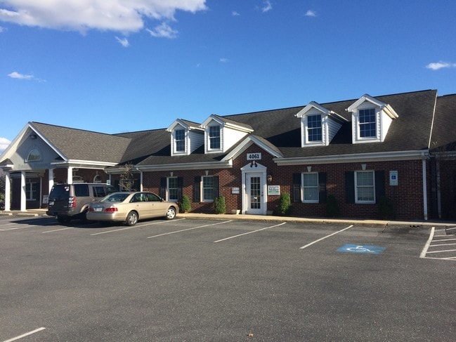
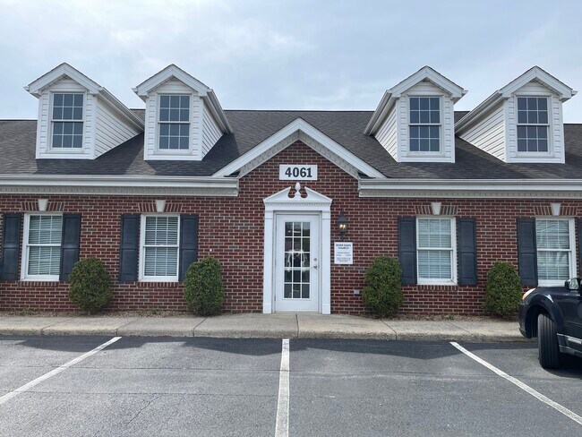
Property Record
4057 Quarles Ct, Rockingham, VA 22801

NEARBY LISTINGS FOR SALE OR LEASE
Property Detail
4057 Quarles Ct
Harrisonburg, VA
Quarles Business Park
126F-8-L2
QUARLES BUSINESS PARK L 2
Commercialnec
Rockingham
X
Virginia
51165C0412D
2
2025
2.07 AC
2025
Staunton & Harrisonburg
011802
Other Market Areas
28,546 SF
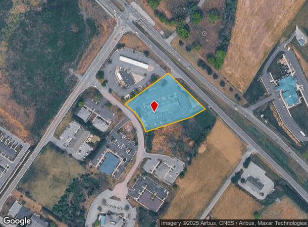
DEMOGRAPHICS near 4057 Quarles Ct
1 Mile
3 Mile
5 Mile
2024 Total Population
3,559
30,522
66,822
2029 Population
3,746
31,038
67,091
Pop Growth 2024-2029
+ 5.25%
+ 1.69%
+ 0.40%
Average Age
45
34
34
2024 Total Households
1,369
10,748
23,093
HH Growth 2024-2029
+ 5.41%
+ 1.98%
+ 0.54%
Median Household Inc
$92,313
$64,859
$60,389
Avg Household Size
2.40
2.50
2.60
2024 Avg HH Vehicles
2.00
2.00
2.00
Median Home Value
$359,686
$327,030
$283,499
Median Year Built
2001
2000
1991
Nearby Places
Map Layers
Map Styles
 Street
 Aerial
- Restaurants
- Banks
- Shops
- Fitness
- Groceries
SALE & LEASE HISTORY
LISTING DATE
SALE/LEASE

May 05, 2017
For Lease
Jul 16, 2024
For Lease
Jan 31, 2019
For Lease
Apr 26, 2021
For Lease
Nearby Properties
Address
Land Use
TOTAL SIZE
Lot Size
Zoning
Address
Land Use
TOTAL SIZE
Lot Size
Zoning
68.88 AC
GENERAL IN
Address
Land Use
TOTAL SIZE
Lot Size
Zoning
114.53 AC
MULTI DWEL
Address
Land Use
TOTAL SIZE
Lot Size
Zoning
122,976 SF
59.92 AC
Address
Land Use
TOTAL SIZE
Lot Size
Zoning
10,560 SF
258 AC
MULTI DWEL
Address
Land Use
TOTAL SIZE
Lot Size
Zoning
36.81 AC
R5
Address
Land Use
TOTAL SIZE
Lot Size
Zoning
219,561 SF
55.38 AC
GENERAL IN
Address
Land Use
TOTAL SIZE
Lot Size
Zoning
11.56 AC
B1
Address
Land Use
TOTAL SIZE
Lot Size
Zoning
1,656 SF
36.28 AC
GENERAL IN
Address
Land Use
TOTAL SIZE
Lot Size
Zoning
16,620 SF
192 AC
HIGH DENSI
Address
Land Use
TOTAL SIZE
Lot Size
Zoning
14,490 SF
190 AC
PLANNED UN
Address
Land Use
TOTAL SIZE
Lot Size
Zoning
17,472 SF
216 AC
HIGH DENSI
Address
Land Use
TOTAL SIZE
Lot Size
Zoning
11.11 AC
R3
Address
Land Use
TOTAL SIZE
Lot Size
Zoning
86,400 SF
37.26 AC
GENERAL BU
Address
Land Use
TOTAL SIZE
Lot Size
Zoning
14,856 SF
168 AC
MULTI DWEL
Address
Land Use
TOTAL SIZE
Lot Size
Zoning
87,636 SF
18.07 AC
GENERAL BU
Address
Land Use
TOTAL SIZE
Lot Size
Zoning
6.10 AC
PMF
Address
Land Use
TOTAL SIZE
Lot Size
Zoning
32,592 SF
4.17 AC
COMMERCIAL
Address
Land Use
TOTAL SIZE
Lot Size
Zoning
9,440 SF
17.31 AC
R3
Address
Land Use
TOTAL SIZE
Lot Size
Zoning
54,943 SF
19.68 AC
GENERAL BU
Address
Land Use
TOTAL SIZE
Lot Size
Zoning
15,432 SF
132 AC
MULTI DWEL
Address
Land Use
TOTAL SIZE
Lot Size
Zoning
78,833 SF
3.76 AC
GENERAL BU
Address
Land Use
TOTAL SIZE
Lot Size
Zoning
13,578 SF
180 AC
HIGH DENSI
Address
Land Use
TOTAL SIZE
Lot Size
Zoning
4,374 SF
17.93 AC
COMMERCIAL
Address
Land Use
TOTAL SIZE
Lot Size
Zoning
15,432 SF
108 AC
MULTI DWEL
Address
Land Use
TOTAL SIZE
Lot Size
Zoning
25,020 SF
3.80 AC
COMMERCIAL
Address
Land Use
TOTAL SIZE
Lot Size
Zoning
13,986 SF
9.87 AC
R3
Address
Land Use
TOTAL SIZE
Lot Size
Zoning
15,244 SF
7.01 AC
R4
Address
Land Use
TOTAL SIZE
Lot Size
Zoning
7,680 SF
15.68 AC
R3
Address
Land Use
TOTAL SIZE
Lot Size
Zoning
79,970 SF
25 AC
A2
Address
Land Use
TOTAL SIZE
Lot Size
Zoning
94,182 SF
2.90 AC
GENERAL BU
The World's #1 Commercial Real Estate Marketplace
Connect with us
© 2025 CoStar Group
The information above has been obtained from sources believed reliable. While we do not doubt its accuracy we have not verified it and make no guarantee, warranty or representation about it. It is your responsibility to independently confirm its accuracy and completeness. Any projections, opinions, assumptions, or estimates used are for example only and do not represent the current or future performance of the property. The value of this transaction to you depends on tax and other factors which should be evaluated by your tax, financial, and legal advisors. You and your advisors should conduct a careful, independent investigation of the property to determine to your satisfaction the suitability of the property for your needs.