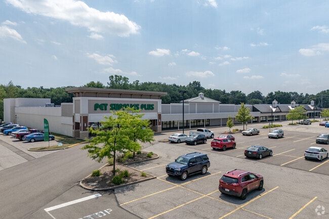
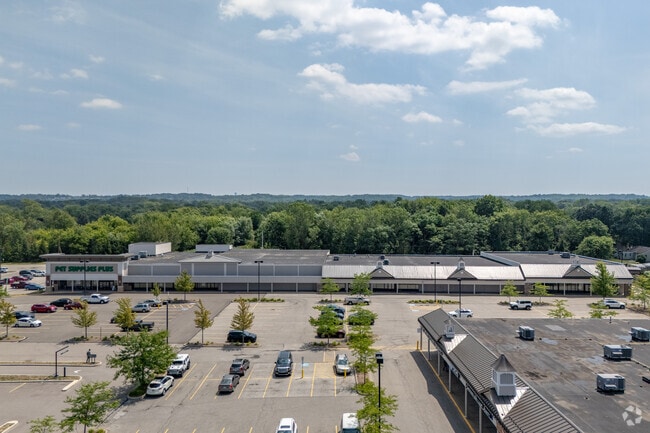
Property Record
4059 Buffalo Rd, Erie, PA 16510

NEARBY LISTINGS FOR SALE OR LEASE
Property Detail
4059 Buffalo Rd
27-051-151.0-017.00
Benderson Trust Glant Eagle Inc
Stripcommercialcenter
4059 BUFFALO RD 9.07 AC NET LDP 2011-20454 EASTWAY PLAZA
X
Erie
42049C0069D
Pennsylvania
2025
9.07 AC
2025
Outlying Erie County
011508
Erie
70,022 SF
Erie, PA
DEMOGRAPHICS near 4059 Buffalo Rd
1 Mile
3 Mile
5 Mile
2024 Total Population
10,070
45,739
96,927
2029 Population
9,994
45,137
95,914
Pop Growth 2024-2029
(0.75%)
(1.32%)
(1.05%)
Average Age
40
40
39
2024 Total Households
3,974
17,672
38,062
HH Growth 2024-2029
(0.96%)
(1.45%)
(1.13%)
Median Household Inc
$57,722
$53,010
$44,821
Avg Household Size
2.40
2.40
2.30
2024 Avg HH Vehicles
2.00
2.00
1.00
Median Home Value
$120,836
$122,268
$116,580
Median Year Built
1956
1960
1955
Nearby Places
Map Layers
Map Styles
 Street
 Aerial
- Restaurants
- Banks
- Shops
- Fitness
- Groceries
PUBLIC TRANSPORTATION
COMMUTER RAIL
Erie Amtrak Station (Lake Shore Limited - Amtrak)
DRIVE
WALK
Distance
Erie Amtrak Station (Lake Shore Limited - Amtrak)
13 min
4.7 mi
AIRPORT
Erie International/Tom Ridge Field
DRIVE
WALK
Distance
Erie International/Tom Ridge Field
24 min
11.6 mi
Freight Ports
Port of Toledo
DRIVE
WALK
Distance
Port of Toledo
262 min
220.6 mi
Nearby Properties
Address
Land Use
TOTAL SIZE
Lot Size
Zoning
Address
Land Use
TOTAL SIZE
Lot Size
Zoning
227,630 SF
343.90 AC
I1
Address
Land Use
TOTAL SIZE
Lot Size
Zoning
68,626 SF
86.88 AC
B1
Address
Land Use
TOTAL SIZE
Lot Size
Zoning
75.24 AC
R2A
Address
Land Use
TOTAL SIZE
Lot Size
Zoning
92,635 SF
8.45 AC
B1
Address
Land Use
TOTAL SIZE
Lot Size
Zoning
8.60 AC
R2
Address
Land Use
TOTAL SIZE
Lot Size
Zoning
23.31 AC
C1
Address
Land Use
TOTAL SIZE
Lot Size
Zoning
18.55 AC
M1
Address
Land Use
TOTAL SIZE
Lot Size
Zoning
59,300 SF
16.25 AC
Address
Land Use
TOTAL SIZE
Lot Size
Zoning
9.38 AC
C1
Address
Land Use
TOTAL SIZE
Lot Size
Zoning
92,284 SF
3.94 AC
B3
Address
Land Use
TOTAL SIZE
Lot Size
Zoning
118,270 SF
5.64 AC
R2A
Address
Land Use
TOTAL SIZE
Lot Size
Zoning
121,197 SF
7.58 AC
Address
Land Use
TOTAL SIZE
Lot Size
Zoning
62.79 AC
R2B
Address
Land Use
TOTAL SIZE
Lot Size
Zoning
41,976 SF
6.50 AC
R2A
Address
Land Use
TOTAL SIZE
Lot Size
Zoning
189,305 SF
42.45 AC
B1
Address
Land Use
TOTAL SIZE
Lot Size
Zoning
4.76 AC
R3
Address
Land Use
TOTAL SIZE
Lot Size
Zoning
13,620 SF
1.21 AC
B1
Address
Land Use
TOTAL SIZE
Lot Size
Zoning
202,500 SF
46.30 AC
I
Address
Land Use
TOTAL SIZE
Lot Size
Zoning
21,451 SF
13.98 AC
Address
Land Use
TOTAL SIZE
Lot Size
Zoning
51.13 AC
R2A
Address
Land Use
TOTAL SIZE
Lot Size
Zoning
89,520 SF
16.38 AC
R3
Address
Land Use
TOTAL SIZE
Lot Size
Zoning
2.67 AC
R2
Address
Land Use
TOTAL SIZE
Lot Size
Zoning
68,102 SF
26.69 AC
M1
Address
Land Use
TOTAL SIZE
Lot Size
Zoning
103,790 SF
3.45 AC
C3
Address
Land Use
TOTAL SIZE
Lot Size
Zoning
71,380 SF
6.66 AC
B1
Address
Land Use
TOTAL SIZE
Lot Size
Zoning
3.60 AC
R1
Address
Land Use
TOTAL SIZE
Lot Size
Zoning
75,487 SF
7.32 AC
R3
Address
Land Use
TOTAL SIZE
Lot Size
Zoning
65,776 SF
5.76 AC
B1
Address
Land Use
TOTAL SIZE
Lot Size
Zoning
66,381 SF
1.90 AC
R1
The World's #1 Commercial Real Estate Marketplace
Connect with us
© 2026 CoStar Group
The information above has been obtained from sources believed reliable. While we do not doubt its accuracy we have not verified it and make no guarantee, warranty or representation about it. It is your responsibility to independently confirm its accuracy and completeness. Any projections, opinions, assumptions, or estimates used are for example only and do not represent the current or future performance of the property. The value of this transaction to you depends on tax and other factors which should be evaluated by your tax, financial, and legal advisors. You and your advisors should conduct a careful, independent investigation of the property to determine to your satisfaction the suitability of the property for your needs.