Property Record
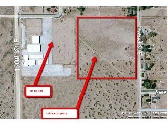
152 Ste Vic Ave, Palmdale, CA 93591

Property Detail
152 Ste Vic Ave
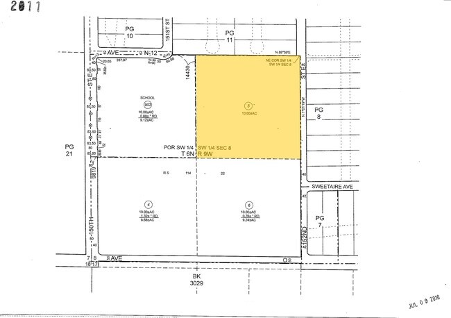
3069-009-005
NE 1/4 OF SW 1/4 OF SW 1/4 OF SEC 8 T6N R9W
Desertorbarrenland
LOS ANGELES
LCRA40000*
California
B and X Area of moderate flood hazard, usually the area between the limits of the 100-year and 500-year floods.
10.34 AC
2024
NE LA County Outlying
2025
Los Angeles
900104
Los Angeles-Long Beach-Glendale, CA
NEARBY LISTINGS FOR SALE OR LEASE
-
-
No Photo
-
View all Palmdale listings for sale on LoopNet.com
DEMOGRAPHICS near 152 Ste Vic Ave
1 mile
3 mile
5 mile
2024 Total Population
1,444
12,443
13,062
2029 Population
1,419
12,264
12,893
Pop Growth 2024-2029
(1.73%)
(1.44%)
(1.29%)
Average Age
36
37
37
2024 Total Households
388
3,401
3,597
HH Growth 2024-2029
(2.06%)
(1.73%)
(1.56%)
Median Household Inc
$64,780
$64,006
$63,377
Avg Household Size
3.60
3.40
3.40
2024 Avg HH Vehicles
2.00
2.00
2.00
Median Home Value
$252,857
$275,579
$276,536
Median Year Built
1981
1981
1981
Nearby Places
Map Layers
Map Styles
 Street
 Aerial
Transit
 Traffic
 Biking
Places
Listings with unknown addresses are not visible on the map
- Restaurants
- Banks
- Shops
- Fitness
- Groceries
Nearby Properties
Address
Land Use
TOTAL SIZE
Lot Size
Zoning
Address
Land Use
TOTAL SIZE
Lot Size
Zoning
12,272 SF
1.47 AC
LCC2*
Address
Land Use
TOTAL SIZE
Lot Size
Zoning
18,511 SF
1.62 AC
LCC2*
Address
Land Use
TOTAL SIZE
Lot Size
Zoning
14,004 SF
1.40 AC
LCRA30000*
Address
Land Use
TOTAL SIZE
Lot Size
Zoning
14,841 SF
3.18 AC
LCA11*
Address
Land Use
TOTAL SIZE
Lot Size
Zoning
9,180 SF
0.55 AC
LCC3
Address
Land Use
TOTAL SIZE
Lot Size
Zoning
17,993 SF
1.88 AC
LCC2*
Address
Land Use
TOTAL SIZE
Lot Size
Zoning
8,829 SF
0.55 AC
LCC2*
Address
Land Use
TOTAL SIZE
Lot Size
Zoning
7,641 SF
0.55 AC
LCC2*
Address
Land Use
TOTAL SIZE
Lot Size
Zoning
9,680 SF
1.51 AC
LCC2*
Address
Land Use
TOTAL SIZE
Lot Size
Zoning
6,804 SF
42.32 AC
LCRA2000*
Address
Land Use
TOTAL SIZE
Lot Size
Zoning
6,965 SF
1.40 AC
LCC2*
Address
Land Use
TOTAL SIZE
Lot Size
Zoning
8,626 SF
0.60 AC
LCC2
Address
Land Use
TOTAL SIZE
Lot Size
Zoning
4,224 SF
41.16 AC
LCA21*
Address
Land Use
TOTAL SIZE
Lot Size
Zoning
9.49 AC
LCRA40000*
Address
Land Use
TOTAL SIZE
Lot Size
Zoning
836 SF
120.09 AC
LCA11*
Address
Land Use
TOTAL SIZE
Lot Size
Zoning
0.50 AC
LCRA20000*
Address
Land Use
TOTAL SIZE
Lot Size
Zoning
168 AC
LCA12*
Address
Land Use
TOTAL SIZE
Lot Size
Zoning
163.01 AC
LCA21*
Address
Land Use
TOTAL SIZE
Lot Size
Zoning
5,196 SF
2.23 AC
LCA21*
Address
Land Use
TOTAL SIZE
Lot Size
Zoning
9,846 SF
0.55 AC
LCC2
Address
Land Use
TOTAL SIZE
Lot Size
Zoning
78.85 AC
LCA12*
Address
Land Use
TOTAL SIZE
Lot Size
Zoning
1,300 SF
0.56 AC
LCC2*
Address
Land Use
TOTAL SIZE
Lot Size
Zoning
2,704 SF
0.58 AC
LCC2*
Address
Land Use
TOTAL SIZE
Lot Size
Zoning
1,264 SF
0.67 AC
LCRA30000*
Address
Land Use
TOTAL SIZE
Lot Size
Zoning
148.98 AC
LCA21*
Address
Land Use
TOTAL SIZE
Lot Size
Zoning
98.86 AC
LCA12*
Address
Land Use
TOTAL SIZE
Lot Size
Zoning
323.24 AC
LCA21*
Address
Land Use
TOTAL SIZE
Lot Size
Zoning
3,940 SF
0.55 AC
LCC2*
Address
Land Use
TOTAL SIZE
Lot Size
Zoning
81.60 AC
LCA11*
Address
Land Use
TOTAL SIZE
Lot Size
Zoning
0.69 AC
LCRA30000*
The World's #1 Commercial Real Estate Marketplace
Connect with us
© 2026 CoStar Group
The information above has been obtained from sources believed reliable. While we do not doubt its accuracy we have not verified it and make no guarantee, warranty or representation about it. It is your responsibility to independently confirm its accuracy and completeness. Any projections, opinions, assumptions, or estimates used are for example only and do not represent the current or future performance of the property. The value of this transaction to you depends on tax and other factors which should be evaluated by your tax, financial, and legal advisors. You and your advisors should conduct a careful, independent investigation of the property to determine to your satisfaction the suitability of the property for your needs.