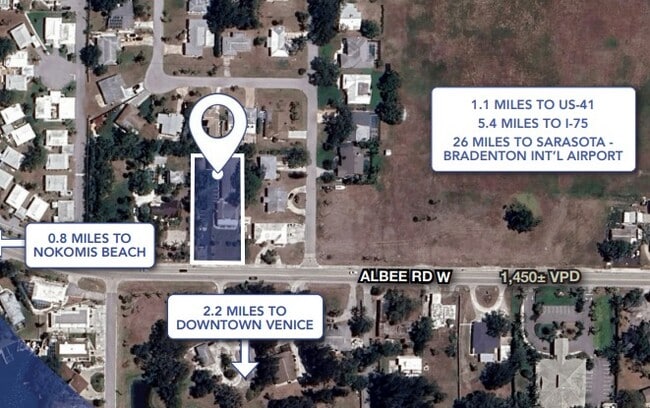
Property Record
406 Albee Rd W, Nokomis, FL 34275
NEARBY LISTINGS FOR SALE OR LEASE
Property Detail
406 Albee Rd W
North Port-Bradenton-Sarasota, FL
Calypso Courts
0171-11-2002
Sarasota
Townhouserowhouse
Florida
AE
0.55 AC
12115C0239G
Venice/Englewood
532 SF
Tampa/St Petersburg
DEMOGRAPHICS near 406 Albee Rd W
1 Mile
3 Mile
5 Mile
2024 Total Population
5,665
39,546
71,624
2029 Population
7,307
50,604
91,121
Pop Growth 2024-2029
+ 28.98%
+ 27.96%
+ 27.22%
Average Age
54
59
60
2024 Total Households
2,838
20,604
36,825
HH Growth 2024-2029
+ 29.03%
+ 28.29%
+ 27.57%
Median Household Inc
$68,513
$65,629
$70,500
Avg Household Size
1.90
1.80
1.90
2024 Avg HH Vehicles
2.00
2.00
2.00
Median Home Value
$365,415
$339,867
$349,551
Median Year Built
1977
1979
1985
Nearby Places
Map Layers
Map Styles
 Street
 Aerial
- Restaurants
- Banks
- Shops
- Fitness
- Groceries
PUBLIC TRANSPORTATION
AIRPORT
Sarasota/Bradenton International
DRIVE
WALK
Distance
Sarasota/Bradenton International
39 min
21.8 mi
Freight Ports
Port Manatee
DRIVE
WALK
Distance
Port Manatee
51 min
40.0 mi
SALE & LEASE HISTORY
LISTING DATE
SALE/LEASE

May 08, 2025
For Sale
Nearby Properties
Address
Land Use
TOTAL SIZE
Lot Size
Zoning
Address
Land Use
TOTAL SIZE
Lot Size
Zoning
738,835 SF
65.43 AC
LW
Address
Land Use
TOTAL SIZE
Lot Size
Zoning
26,265 SF
210.50 AC
RMH
Address
Land Use
TOTAL SIZE
Lot Size
Zoning
592,021 SF
75.99 AC
G
Address
Land Use
TOTAL SIZE
Lot Size
Zoning
273,036 SF
28.76 AC
RMF3
Address
Land Use
TOTAL SIZE
Lot Size
Zoning
263,056 SF
25.54 AC
LW
Address
Land Use
TOTAL SIZE
Lot Size
Zoning
8,017 SF
56 AC
RMH
Address
Land Use
TOTAL SIZE
Lot Size
Zoning
181,657 SF
56.90 AC
GU
Address
Land Use
TOTAL SIZE
Lot Size
Zoning
8,562 SF
58.92 AC
RMH
Address
Land Use
TOTAL SIZE
Lot Size
Zoning
23,348 SF
77.03 AC
RMH
Address
Land Use
TOTAL SIZE
Lot Size
Zoning
190,485 SF
5.81 AC
NTG
Address
Land Use
TOTAL SIZE
Lot Size
Zoning
48,681 SF
5 AC
OPI
Address
Land Use
TOTAL SIZE
Lot Size
Zoning
133,773 SF
6.29 AC
OPI
Address
Land Use
TOTAL SIZE
Lot Size
Zoning
425,768 SF
18.41 AC
RMF2
Address
Land Use
TOTAL SIZE
Lot Size
Zoning
5,396 SF
33.59 AC
RMH
Address
Land Use
TOTAL SIZE
Lot Size
Zoning
5,208 SF
38.03 AC
CG
Address
Land Use
TOTAL SIZE
Lot Size
Zoning
17,028 SF
3.57 AC
RE2
Address
Land Use
TOTAL SIZE
Lot Size
Zoning
12,263 SF
3.38 AC
RE2
Address
Land Use
TOTAL SIZE
Lot Size
Zoning
127,135 SF
12.37 AC
CG
Address
Land Use
TOTAL SIZE
Lot Size
Zoning
70,220 SF
9.31 AC
LW
Address
Land Use
TOTAL SIZE
Lot Size
Zoning
49,400 SF
4.51 AC
OPI
Address
Land Use
TOTAL SIZE
Lot Size
Zoning
45,837 SF
3.06 AC
G
Address
Land Use
TOTAL SIZE
Lot Size
Zoning
139,551 SF
14.60 AC
CSC
Address
Land Use
TOTAL SIZE
Lot Size
Zoning
112,788 SF
3.06 AC
CG
Address
Land Use
TOTAL SIZE
Lot Size
Zoning
40.20 AC
RMH
Address
Land Use
TOTAL SIZE
Lot Size
Zoning
55,417 SF
5.64 AC
CG
Address
Land Use
TOTAL SIZE
Lot Size
Zoning
59,645 SF
2.68 AC
CG
Address
Land Use
TOTAL SIZE
Lot Size
Zoning
18.76 AC
CG
Address
Land Use
TOTAL SIZE
Lot Size
Zoning
30,553 SF
5.03 AC
G
Address
Land Use
TOTAL SIZE
Lot Size
Zoning
100,001 SF
5.14 AC
CG
Address
Land Use
TOTAL SIZE
Lot Size
Zoning
22,826 SF
1.15 AC
RTR
The World's #1 Commercial Real Estate Marketplace
Connect with us
© 2026 CoStar Group
The information above has been obtained from sources believed reliable. While we do not doubt its accuracy we have not verified it and make no guarantee, warranty or representation about it. It is your responsibility to independently confirm its accuracy and completeness. Any projections, opinions, assumptions, or estimates used are for example only and do not represent the current or future performance of the property. The value of this transaction to you depends on tax and other factors which should be evaluated by your tax, financial, and legal advisors. You and your advisors should conduct a careful, independent investigation of the property to determine to your satisfaction the suitability of the property for your needs.