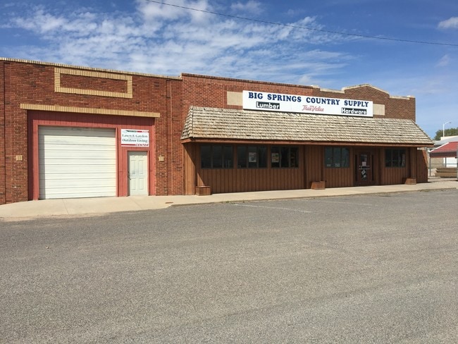
Property Record
406 Chestnut St, Big Springs, NE 69122

NEARBY LISTINGS FOR SALE OR LEASE
-
-
View all Big Springs listings for sale on LoopNet.com
Property Detail
406 Chestnut St
0003115.00
Thompson Add
Publicstorage
LOT 1 EXCEPT W 36' & LOT 2 EXCEPT N 3.8'OF W 36' LOTS 3 & 4 & N/2 LOT 5 BLOCK 9 THOMPSON ADDITION TO BIG SPRINGS
X
Deuel
31049C0230C
Nebraska
2024
1-5
2025
0.68 AC
955400
I-80 Corridor
4,996 SF
Other Market Areas
DEMOGRAPHICS near 406 Chestnut St
1 Mile
3 Mile
5 Mile
2024 Total Population
535
582
638
2029 Population
564
613
669
Pop Growth 2024-2029
+ 5.42%
+ 5.33%
+ 4.86%
Average Age
46
46
46
2024 Total Households
231
251
275
HH Growth 2024-2029
+ 4.76%
+ 4.78%
+ 4.36%
Median Household Inc
$61,579
$61,463
$61,667
Avg Household Size
2.30
2.30
2.30
2024 Avg HH Vehicles
2.00
2.00
3.00
Median Home Value
$115,384
$116,071
$124,590
Median Year Built
1950
1951
1952
Nearby Places
Map Layers
Map Styles
 Street
 Aerial
- Restaurants
- Banks
- Shops
- Fitness
- Groceries
SALE & LEASE HISTORY
LISTING DATE
SALE/LEASE

Jul 11, 2017
For Sale
Nearby Properties
Address
Land Use
TOTAL SIZE
Lot Size
Zoning
Address
Land Use
TOTAL SIZE
Lot Size
Zoning
60,673 SF
24.97 AC
03-COMMERC
Address
Land Use
TOTAL SIZE
Lot Size
Zoning
25,050 SF
32.15 AC
03-COMMERC
Address
Land Use
TOTAL SIZE
Lot Size
Zoning
6,418 SF
4.54 AC
03-COMMERC
Address
Land Use
TOTAL SIZE
Lot Size
Zoning
22,100 SF
2.91 AC
03-COMMERC
Address
Land Use
TOTAL SIZE
Lot Size
Zoning
960 SF
03-COMMERC
Address
Land Use
TOTAL SIZE
Lot Size
Zoning
1,776 SF
1.74 AC
07-OTHER
Address
Land Use
TOTAL SIZE
Lot Size
Zoning
1,800 SF
11.72 AC
05-AGRICUL
Address
Land Use
TOTAL SIZE
Lot Size
Zoning
7,470 SF
1.13 AC
03-COMMERC
Address
Land Use
TOTAL SIZE
Lot Size
Zoning
3,280 SF
3.21 AC
03-COMMERC
Address
Land Use
TOTAL SIZE
Lot Size
Zoning
149.11 AC
05-AGRICUL
Address
Land Use
TOTAL SIZE
Lot Size
Zoning
9,600 SF
4.74 AC
05-AGRICUL
Address
Land Use
TOTAL SIZE
Lot Size
Zoning
5,229 SF
0.32 AC
00
Address
Land Use
TOTAL SIZE
Lot Size
Zoning
1,800 SF
156.01 AC
05-AGRICUL
Address
Land Use
TOTAL SIZE
Lot Size
Zoning
140.05 AC
05-AGRICUL
Address
Land Use
TOTAL SIZE
Lot Size
Zoning
3,201 SF
0.24 AC
03-COMMERC
Address
Land Use
TOTAL SIZE
Lot Size
Zoning
9,600 SF
05-AGRICUL
Address
Land Use
TOTAL SIZE
Lot Size
Zoning
6,000 SF
0.32 AC
03-COMMERC
Address
Land Use
TOTAL SIZE
Lot Size
Zoning
3,584 SF
0.34 AC
03-COMMERC
Address
Land Use
TOTAL SIZE
Lot Size
Zoning
65.90 AC
05-AGRICUL
Address
Land Use
TOTAL SIZE
Lot Size
Zoning
62.58 AC
05-AGRICUL
Address
Land Use
TOTAL SIZE
Lot Size
Zoning
4,827 SF
4.90 AC
03-COMMERC
Address
Land Use
TOTAL SIZE
Lot Size
Zoning
894 SF
03-COMMERC
Address
Land Use
TOTAL SIZE
Lot Size
Zoning
4,000 SF
0.30 AC
03-COMMERC
Address
Land Use
TOTAL SIZE
Lot Size
Zoning
3,504 SF
4.07 AC
03-COMMERC
Address
Land Use
TOTAL SIZE
Lot Size
Zoning
80.32 AC
05-AGRICUL
Address
Land Use
TOTAL SIZE
Lot Size
Zoning
931 SF
3.34 AC
03-COMMERC
Address
Land Use
TOTAL SIZE
Lot Size
Zoning
1,704 SF
0.27 AC
03-COMMERC
Address
Land Use
TOTAL SIZE
Lot Size
Zoning
90.05 AC
05-AGRICUL
Address
Land Use
TOTAL SIZE
Lot Size
Zoning
313.69 AC
05-AGRICUL
The World's #1 Commercial Real Estate Marketplace
Connect with us
© 2026 CoStar Group
The information above has been obtained from sources believed reliable. While we do not doubt its accuracy we have not verified it and make no guarantee, warranty or representation about it. It is your responsibility to independently confirm its accuracy and completeness. Any projections, opinions, assumptions, or estimates used are for example only and do not represent the current or future performance of the property. The value of this transaction to you depends on tax and other factors which should be evaluated by your tax, financial, and legal advisors. You and your advisors should conduct a careful, independent investigation of the property to determine to your satisfaction the suitability of the property for your needs.