Property Record
406 E Main St, Corry, PA 16407
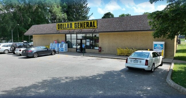

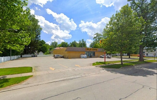
This Property Is For Sale
Property Detail
406 E Main St
05-028-181.0-001.00
406 E MAIN ST 166 X 169.5
Storebuilding
Erie
R2
Pennsylvania
B and X Area of moderate flood hazard, usually the area between the limits of the 100-year and 500-year floods.
0.65 AC
2025
Outlying Erie County
2025
Erie
011900
Erie, PA
8,160 SF
NEARBY LISTINGS FOR SALE OR LEASE
DEMOGRAPHICS near 406 E Main St
1 mile
3 mile
5 mile
2025 Total Population
5,035
7,862
9,550
2030 Population
5,003
7,772
9,419
Pop Growth 2025-2030
(0.64%)
(1.14%)
(1.37%)
Average Age
41
42
42
2025 Total Households
2,075
3,211
3,888
HH Growth 2025-2030
(0.67%)
(1.18%)
(1.41%)
Median Household Inc
$43,098
$47,473
$49,340
Avg Household Size
2.30
2.40
2.40
2025 Avg HH Vehicles
1.00
2.00
2.00
Median Home Value
$97,840
$119,886
$131,915
Median Year Built
1948
1951
1953
Nearby Places
Map Layers
Map Styles
 Street
 Aerial
Transit
 Traffic
 Biking
Places
Listings with unknown addresses are not visible on the map
- Restaurants
- Banks
- Shops
- Fitness
- Groceries
PUBLIC TRANSPORTATION
AIRPORT
Erie International/Tom Ridge Field
Drive
Walk
Distance
Erie International/Tom Ridge Field
62 min
37.4 mi
Nearby Properties
Address
Land Use
TOTAL SIZE
Lot Size
Zoning
Address
Land Use
TOTAL SIZE
Lot Size
Zoning
78,300 SF
16.69 AC
Address
Land Use
TOTAL SIZE
Lot Size
Zoning
2,240 SF
54.20 AC
R1
Address
Land Use
TOTAL SIZE
Lot Size
Zoning
9.97 AC
R1
Address
Land Use
TOTAL SIZE
Lot Size
Zoning
111,300 SF
11.84 AC
C2
Address
Land Use
TOTAL SIZE
Lot Size
Zoning
2.50 AC
R2
Address
Land Use
TOTAL SIZE
Lot Size
Zoning
34,012 SF
6.77 AC
R2
Address
Land Use
TOTAL SIZE
Lot Size
Zoning
312,396 SF
38.21 AC
R2
Address
Land Use
TOTAL SIZE
Lot Size
Zoning
8.23 AC
R1
Address
Land Use
TOTAL SIZE
Lot Size
Zoning
2.50 AC
I1
Address
Land Use
TOTAL SIZE
Lot Size
Zoning
4.25 AC
C2
Address
Land Use
TOTAL SIZE
Lot Size
Zoning
479,968 SF
28.04 AC
I2
Address
Land Use
TOTAL SIZE
Lot Size
Zoning
43,255 SF
5.70 AC
R1
Address
Land Use
TOTAL SIZE
Lot Size
Zoning
1.56 AC
R1
Address
Land Use
TOTAL SIZE
Lot Size
Zoning
4.15 AC
R1
Address
Land Use
TOTAL SIZE
Lot Size
Zoning
17,784 SF
2.26 AC
Address
Land Use
TOTAL SIZE
Lot Size
Zoning
2.07 AC
R2
Address
Land Use
TOTAL SIZE
Lot Size
Zoning
1,834 SF
186.56 AC
Address
Land Use
TOTAL SIZE
Lot Size
Zoning
155,406 SF
11.06 AC
Address
Land Use
TOTAL SIZE
Lot Size
Zoning
1.85 AC
S1
Address
Land Use
TOTAL SIZE
Lot Size
Zoning
121,836 SF
3.78 AC
I2
Address
Land Use
TOTAL SIZE
Lot Size
Zoning
45,680 SF
4.61 AC
R1
Address
Land Use
TOTAL SIZE
Lot Size
Zoning
44,380 SF
1.42 AC
C2
Address
Land Use
TOTAL SIZE
Lot Size
Zoning
1.26 AC
I1
Address
Land Use
TOTAL SIZE
Lot Size
Zoning
33,900 SF
3.72 AC
Address
Land Use
TOTAL SIZE
Lot Size
Zoning
0.34 AC
R2
Address
Land Use
TOTAL SIZE
Lot Size
Zoning
1,884 SF
8.35 AC
C2
Address
Land Use
TOTAL SIZE
Lot Size
Zoning
34,641 SF
2.89 AC
C2
Address
Land Use
TOTAL SIZE
Lot Size
Zoning
0.79 AC
C2
Address
Land Use
TOTAL SIZE
Lot Size
Zoning
0.43 AC
I1
Address
Land Use
TOTAL SIZE
Lot Size
Zoning
5,192 SF
7.84 AC
R1
The World's #1 Commercial Real Estate Marketplace
Connect with us
© 2026 CoStar Group
The information above has been obtained from sources believed reliable. While we do not doubt its accuracy we have not verified it and make no guarantee, warranty or representation about it. It is your responsibility to independently confirm its accuracy and completeness. Any projections, opinions, assumptions, or estimates used are for example only and do not represent the current or future performance of the property. The value of this transaction to you depends on tax and other factors which should be evaluated by your tax, financial, and legal advisors. You and your advisors should conduct a careful, independent investigation of the property to determine to your satisfaction the suitability of the property for your needs.