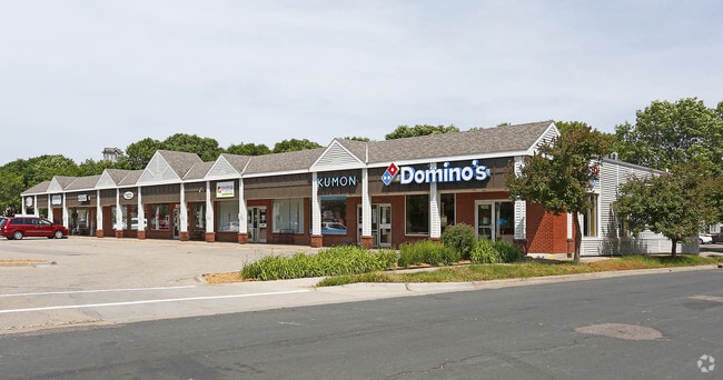
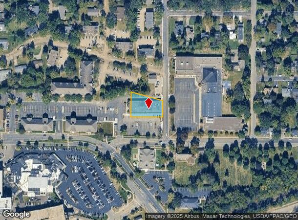
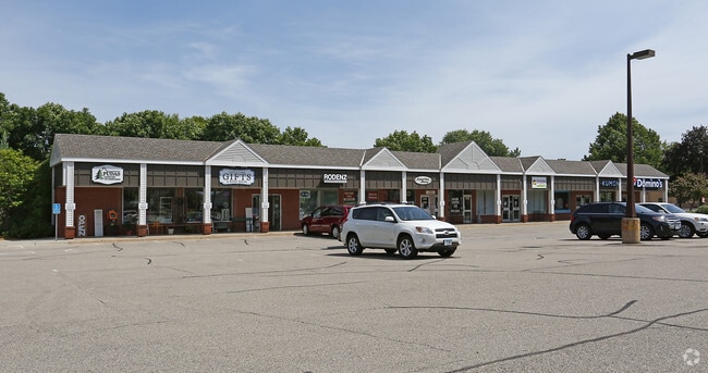
Property Record
406 W 78Th St, Chanhassen, MN 55317
NEARBY LISTINGS FOR SALE OR LEASE
Property Detail
406 W 78Th St
25.1730010
Chadda 2Nd Addition
Stripcommercialcenter
Carver
X
Minnesota
27019C0231D
1
2025
0.48 AC
2025
Eden Prairie
090601
Minneapolis/St Paul
12,600 SF
Minneapolis-St. Paul-Bloomington, MN-WI
DEMOGRAPHICS near 406 W 78Th St
1 Mile
3 Mile
5 Mile
2024 Total Population
5,953
49,178
116,565
2029 Population
6,279
50,333
118,592
Pop Growth 2024-2029
+ 5.48%
+ 2.35%
+ 1.74%
Average Age
43
41
41
2024 Total Households
2,465
18,439
45,047
HH Growth 2024-2029
+ 6.09%
+ 2.47%
+ 1.74%
Median Household Inc
$94,444
$129,088
$112,132
Avg Household Size
2.40
2.60
2.50
2024 Avg HH Vehicles
2.00
2.00
2.00
Median Home Value
$405,990
$471,659
$448,080
Median Year Built
1984
1989
1987
Nearby Places
Map Layers
Map Styles
 Street
 Aerial
- Restaurants
- Banks
- Shops
- Fitness
- Groceries
PUBLIC TRANSPORTATION
AIRPORT
Minneapolis-St Paul International/Wold-Chamberlain
DRIVE
WALK
Distance
Minneapolis-St Paul International/Wold-Chamberlain
25 min
17.0 mi
Freight Ports
Port Milwaukee
DRIVE
WALK
Distance
Port Milwaukee
393 min
354.1 mi
SALE & LEASE HISTORY
LISTING DATE
SALE/LEASE

Sep 25, 2016
For Lease
Nearby Properties
Address
Land Use
TOTAL SIZE
Lot Size
Zoning
Address
Land Use
TOTAL SIZE
Lot Size
Zoning
60,208 SF
47.61 AC
Address
Land Use
TOTAL SIZE
Lot Size
Zoning
136,782 SF
6.17 AC
Address
Land Use
TOTAL SIZE
Lot Size
Zoning
73,017 SF
10.04 AC
Address
Land Use
TOTAL SIZE
Lot Size
Zoning
1.11 AC
Address
Land Use
TOTAL SIZE
Lot Size
Zoning
8.66 AC
Address
Land Use
TOTAL SIZE
Lot Size
Zoning
122,807 SF
30.62 AC
Address
Land Use
TOTAL SIZE
Lot Size
Zoning
3,073 SF
155.36 AC
Address
Land Use
TOTAL SIZE
Lot Size
Zoning
3.82 AC
Address
Land Use
TOTAL SIZE
Lot Size
Zoning
330,000 SF
57.81 AC
Address
Land Use
TOTAL SIZE
Lot Size
Zoning
3.69 AC
Address
Land Use
TOTAL SIZE
Lot Size
Zoning
24,363 SF
18.56 AC
Address
Land Use
TOTAL SIZE
Lot Size
Zoning
21.72 AC
Address
Land Use
TOTAL SIZE
Lot Size
Zoning
22.50 AC
Address
Land Use
TOTAL SIZE
Lot Size
Zoning
94,387 SF
14.77 AC
Address
Land Use
TOTAL SIZE
Lot Size
Zoning
17.67 AC
R4
Address
Land Use
TOTAL SIZE
Lot Size
Zoning
3.20 AC
Address
Land Use
TOTAL SIZE
Lot Size
Zoning
85,425 SF
8.21 AC
C-COM
Address
Land Use
TOTAL SIZE
Lot Size
Zoning
34,100 SF
12.99 AC
Address
Land Use
TOTAL SIZE
Lot Size
Zoning
301,389 SF
36.47 AC
Address
Land Use
TOTAL SIZE
Lot Size
Zoning
16,576 SF
4.84 AC
Address
Land Use
TOTAL SIZE
Lot Size
Zoning
181,405 SF
14.06 AC
Address
Land Use
TOTAL SIZE
Lot Size
Zoning
16.38 AC
Address
Land Use
TOTAL SIZE
Lot Size
Zoning
140,800 SF
12.39 AC
Address
Land Use
TOTAL SIZE
Lot Size
Zoning
8.49 AC
Address
Land Use
TOTAL SIZE
Lot Size
Zoning
30,970 SF
3.46 AC
Address
Land Use
TOTAL SIZE
Lot Size
Zoning
13.35 AC
Address
Land Use
TOTAL SIZE
Lot Size
Zoning
19.47 AC
Address
Land Use
TOTAL SIZE
Lot Size
Zoning
34,423 SF
2.02 AC
Address
Land Use
TOTAL SIZE
Lot Size
Zoning
88,205 SF
8.91 AC
Address
Land Use
TOTAL SIZE
Lot Size
Zoning
6 AC
I-GEN
The World's #1 Commercial Real Estate Marketplace
Connect with us
© 2025 CoStar Group
The information above has been obtained from sources believed reliable. While we do not doubt its accuracy we have not verified it and make no guarantee, warranty or representation about it. It is your responsibility to independently confirm its accuracy and completeness. Any projections, opinions, assumptions, or estimates used are for example only and do not represent the current or future performance of the property. The value of this transaction to you depends on tax and other factors which should be evaluated by your tax, financial, and legal advisors. You and your advisors should conduct a careful, independent investigation of the property to determine to your satisfaction the suitability of the property for your needs.