Property Record
4060 Duncanville Rd, Dallas, TX 75236
NEARBY LISTINGS FOR SALE OR LEASE
Property Detail
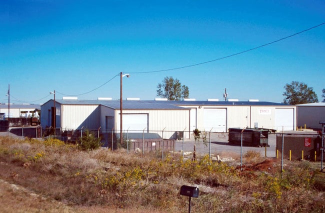
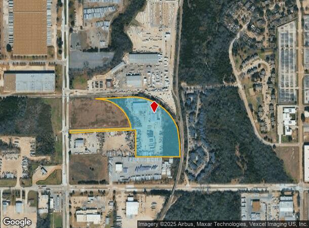
4060 Duncanville Rd
Dallas-Fort Worth-Arlington, TX
Pan L Mill Replat
0069620A0001A0000
PAN L MILL REPLAT BLK A/6962 LOT 1A ACS 10.9494 VOL94031/4790 DD020294 CO-DALLAS 6962 00A 01A0 2006962 00A
Warehouse
Dallas
X
Texas
48113C0460K
1a
2024
10.95 AC
2025
Redbird Airport
016534
Dallas/Ft Worth
37,375 SF
DEMOGRAPHICS near 4060 Duncanville Rd
1 Mile
3 Mile
5 Mile
2024 Total Population
6,740
76,882
235,943
2029 Population
6,704
76,009
232,870
Pop Growth 2024-2029
(0.53%)
(1.14%)
(1.30%)
Average Age
33
35
36
2024 Total Households
2,145
24,723
76,507
HH Growth 2024-2029
(0.65%)
(1.22%)
(1.49%)
Median Household Inc
$50,886
$48,263
$50,349
Avg Household Size
3.10
3.00
3.00
2024 Avg HH Vehicles
2.00
2.00
2.00
Median Home Value
$189,393
$182,011
$196,187
Median Year Built
1977
1978
1974
Nearby Places
Map Layers
Map Styles
 Street
 Aerial
- Restaurants
- Banks
- Shops
- Fitness
- Groceries
PUBLIC TRANSPORTATION
AIRPORT
Dallas Love Field
DRIVE
WALK
Distance
Dallas Love Field
27 min
15.4 mi
Dallas-Fort Worth International
DRIVE
WALK
Distance
Dallas-Fort Worth International
31 min
22.6 mi
Nearby Properties
Address
Land Use
TOTAL SIZE
Lot Size
Zoning
Address
Land Use
TOTAL SIZE
Lot Size
Zoning
459,985 SF
179.23 AC
Z06
Address
Land Use
TOTAL SIZE
Lot Size
Zoning
344,801 SF
7.24 AC
Z125
Address
Land Use
TOTAL SIZE
Lot Size
Zoning
192,086 SF
27.05 AC
Z125
Address
Land Use
TOTAL SIZE
Lot Size
Zoning
263,255 SF
28.40 AC
Z239
Address
Land Use
TOTAL SIZE
Lot Size
Zoning
399,458 SF
24.51 AC
MF2
Address
Land Use
TOTAL SIZE
Lot Size
Zoning
381,633 SF
21.25 AC
Z239
Address
Land Use
TOTAL SIZE
Lot Size
Zoning
310,850 SF
13.17 AC
Z239
Address
Land Use
TOTAL SIZE
Lot Size
Zoning
663,000 SF
40.70 AC
Z116
Address
Land Use
TOTAL SIZE
Lot Size
Zoning
203,593 SF
11.20 AC
Z239
Address
Land Use
TOTAL SIZE
Lot Size
Zoning
552,991 SF
34.27 AC
Z164
Address
Land Use
TOTAL SIZE
Lot Size
Zoning
374,400 SF
6.15 AC
Z150
Address
Land Use
TOTAL SIZE
Lot Size
Zoning
287,697 SF
18.15 AC
Z411
Address
Land Use
TOTAL SIZE
Lot Size
Zoning
274,581 SF
15.55 AC
Z46
Address
Land Use
TOTAL SIZE
Lot Size
Zoning
164,120 SF
15.85 AC
Z163
Address
Land Use
TOTAL SIZE
Lot Size
Zoning
207,440 SF
28.36 AC
Z239
Address
Land Use
TOTAL SIZE
Lot Size
Zoning
138,645 SF
195.45 AC
Z298
Address
Land Use
TOTAL SIZE
Lot Size
Zoning
131,904 SF
11.99 AC
Z297
Address
Land Use
TOTAL SIZE
Lot Size
Zoning
237,127 SF
12.43 AC
Z164
Address
Land Use
TOTAL SIZE
Lot Size
Zoning
414,118 SF
49.01 AC
Z294
Address
Land Use
TOTAL SIZE
Lot Size
Zoning
350,000 SF
19.77 AC
Z109
Address
Land Use
TOTAL SIZE
Lot Size
Zoning
324,320 SF
17.30 AC
Z164
Address
Land Use
TOTAL SIZE
Lot Size
Zoning
187,130 SF
15.39 AC
Z163
Address
Land Use
TOTAL SIZE
Lot Size
Zoning
500,000 SF
25 AC
Z116
Address
Land Use
TOTAL SIZE
Lot Size
Zoning
179,100 SF
9.91 AC
Z163
Address
Land Use
TOTAL SIZE
Lot Size
Zoning
235,897 SF
7.97 AC
Z150
Address
Land Use
TOTAL SIZE
Lot Size
Zoning
100,220 SF
28.26 AC
Z116
Address
Land Use
TOTAL SIZE
Lot Size
Zoning
465,000 SF
24.71 AC
Z116
Address
Land Use
TOTAL SIZE
Lot Size
Zoning
248,376 SF
15.62 AC
Z164
Address
Land Use
TOTAL SIZE
Lot Size
Zoning
194,837 SF
10.79 AC
Z09
Address
Land Use
TOTAL SIZE
Lot Size
Zoning
142,616 SF
13.99 AC
Z125
The World's #1 Commercial Real Estate Marketplace
Connect with us
© 2025 CoStar Group
The information above has been obtained from sources believed reliable. While we do not doubt its accuracy we have not verified it and make no guarantee, warranty or representation about it. It is your responsibility to independently confirm its accuracy and completeness. Any projections, opinions, assumptions, or estimates used are for example only and do not represent the current or future performance of the property. The value of this transaction to you depends on tax and other factors which should be evaluated by your tax, financial, and legal advisors. You and your advisors should conduct a careful, independent investigation of the property to determine to your satisfaction the suitability of the property for your needs.