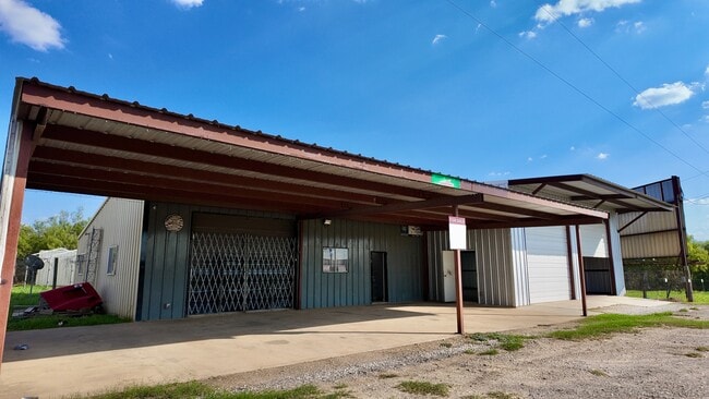
Property Record
4060 Interstate 35 N, Natalia, TX 78059

Save to a Folder
{{folder.Name}}
{{folder.ListingIds.length}} Properties
{{folder.ListingIds.length}} Property
Create a New Folder
Property Detail
4060 Interstate 35 N
9019
A0968 D. TRIMBLE SURVEY 519 1/2; .229 ACRES
Commercialnec
MEDINA
B and X Area of moderate flood hazard, usually the area between the limits of the 100-year and 500-year floods.
Texas
2025
0.23 AC
2025
Medina County
000401
San Antonio
3,900 SF
San Antonio-New Braunfels, TX
NEARBY LISTINGS FOR SALE OR LEASE
DEMOGRAPHICS near 4060 Interstate 35 N
1 mile
3 mile
5 mile
2025 Total Population
1,011
7,053
13,279
2030 Population
1,018
7,360
13,906
Pop Growth 2025-2030
+ 0.69%
+ 4.35%
+ 4.72%
Average Age
39
40
40
2025 Total Households
311
2,359
4,378
HH Growth 2025-2030
+ 0.96%
+ 4.75%
+ 5.03%
Median Household Inc
$59,999
$61,970
$65,718
Avg Household Size
3.10
2.90
3.00
2025 Avg HH Vehicles
2.00
2.00
2.00
Median Home Value
$187,618
$181,389
$186,559
Median Year Built
1987
1990
1991
Nearby Places
Map Layers
Map Styles
 Street
 Aerial
Layers
 Traffic
 Biking
Places
Listings with unknown addresses are not visible on the map
- Restaurants
- Banks
- Shops
- Fitness
- Groceries
PUBLIC TRANSPORTATION
AIRPORT
San Antonio International
Drive
Walk
Distance
San Antonio International
43 min
34.0 mi
SALE & LEASE HISTORY
LISTING DATE
SALE/LEASE

Aug 20, 2025
For Sale
Nearby Properties
Address
Land Use
TOTAL SIZE
Lot Size
Zoning
Address
Land Use
TOTAL SIZE
Lot Size
Zoning
112,135 SF
25.21 AC
Address
Land Use
TOTAL SIZE
Lot Size
Zoning
530,629 SF
17.05 AC
Address
Land Use
TOTAL SIZE
Lot Size
Zoning
21,136 SF
7.58 AC
Address
Land Use
TOTAL SIZE
Lot Size
Zoning
40,658 SF
1.76 AC
Address
Land Use
TOTAL SIZE
Lot Size
Zoning
32,030 SF
4.09 AC
Address
Land Use
TOTAL SIZE
Lot Size
Zoning
21,734 SF
2.49 AC
Address
Land Use
TOTAL SIZE
Lot Size
Zoning
38,975 SF
5.71 AC
Address
Land Use
TOTAL SIZE
Lot Size
Zoning
10,224 SF
1.42 AC
Address
Land Use
TOTAL SIZE
Lot Size
Zoning
2,400 SF
343.76 AC
Address
Land Use
TOTAL SIZE
Lot Size
Zoning
13,418 SF
3.50 AC
Address
Land Use
TOTAL SIZE
Lot Size
Zoning
20,231 SF
1.40 AC
Address
Land Use
TOTAL SIZE
Lot Size
Zoning
28,953 SF
4.53 AC
Address
Land Use
TOTAL SIZE
Lot Size
Zoning
8,375 SF
0.72 AC
Address
Land Use
TOTAL SIZE
Lot Size
Zoning
6,783 SF
1.27 AC
Address
Land Use
TOTAL SIZE
Lot Size
Zoning
4,757 SF
4.80 AC
Address
Land Use
TOTAL SIZE
Lot Size
Zoning
19,800 SF
3.12 AC
Address
Land Use
TOTAL SIZE
Lot Size
Zoning
16,250 SF
1.99 AC
Address
Land Use
TOTAL SIZE
Lot Size
Zoning
10,590 SF
2.48 AC
Address
Land Use
TOTAL SIZE
Lot Size
Zoning
21,588 SF
1.10 AC
Address
Land Use
TOTAL SIZE
Lot Size
Zoning
16,491 SF
0.97 AC
Address
Land Use
TOTAL SIZE
Lot Size
Zoning
9,970 SF
11.08 AC
Address
Land Use
TOTAL SIZE
Lot Size
Zoning
8,246 SF
1.59 AC
Address
Land Use
TOTAL SIZE
Lot Size
Zoning
56,686 SF
11.20 AC
Address
Land Use
TOTAL SIZE
Lot Size
Zoning
11,380 SF
0.52 AC
Address
Land Use
TOTAL SIZE
Lot Size
Zoning
27.64 AC
Address
Land Use
TOTAL SIZE
Lot Size
Zoning
9,275 SF
2.91 AC
Address
Land Use
TOTAL SIZE
Lot Size
Zoning
9,500 SF
1.37 AC
Address
Land Use
TOTAL SIZE
Lot Size
Zoning
25,090 SF
2.71 AC
The World's #1 Commercial Real Estate Marketplace
Connect with us
© 2026 CoStar Group
The information above has been obtained from sources believed reliable. While we do not doubt its accuracy we have not verified it and make no guarantee, warranty or representation about it. It is your responsibility to independently confirm its accuracy and completeness. Any projections, opinions, assumptions, or estimates used are for example only and do not represent the current or future performance of the property. The value of this transaction to you depends on tax and other factors which should be evaluated by your tax, financial, and legal advisors. You and your advisors should conduct a careful, independent investigation of the property to determine to your satisfaction the suitability of the property for your needs.