Property Record
4060 Johns Creek Cir, Duluth, GA 30097

NEARBY LISTINGS FOR SALE OR LEASE
Property Detail
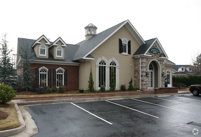
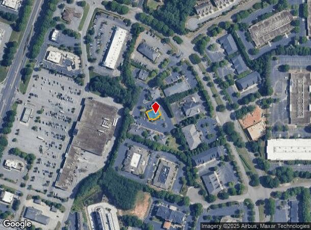
4060 Johns Creek Cir
Atlanta-Sandy Springs-Roswell, GA
Commons At Johns Creek
140-067
1-1 401 TRACT B COMMONS @ JOHNS CREEK
Commercialnec
Forsyth
X
Georgia
13121C0083F
401
2024
0.07 AC
2025
N Fulton/Forsyth County
050234
Atlanta
4,043 SF
DEMOGRAPHICS near 4060 Johns Creek Cir
1 Mile
3 Mile
5 Mile
2024 Total Population
5,384
67,823
184,943
2029 Population
6,056
72,887
198,339
Pop Growth 2024-2029
+ 12.48%
+ 7.47%
+ 7.24%
Average Age
41
39
39
2024 Total Households
1,745
21,601
61,655
HH Growth 2024-2029
+ 12.55%
+ 7.44%
+ 7.26%
Median Household Inc
$141,833
$157,184
$137,891
Avg Household Size
3.00
3.10
3.00
2024 Avg HH Vehicles
2.00
2.00
2.00
Median Home Value
$641,362
$522,216
$476,444
Median Year Built
2003
1997
1997
Nearby Places
Map Layers
Map Styles
 Street
 Aerial
- Restaurants
- Banks
- Shops
- Fitness
- Groceries
PUBLIC TRANSPORTATION
AIRPORT
Hartsfield - Jackson Atlanta International
DRIVE
WALK
Distance
Hartsfield - Jackson Atlanta International
58 min
39.3 mi
SALE & LEASE HISTORY
LISTING DATE
SALE/LEASE

Jul 14, 2021
For Sale
Jan 12, 2019
For Lease
Nearby Properties
Address
Land Use
TOTAL SIZE
Lot Size
Zoning
Address
Land Use
TOTAL SIZE
Lot Size
Zoning
321,541 SF
63.16 AC
OI
Address
Land Use
TOTAL SIZE
Lot Size
Zoning
2,044,910 SF
30.61 AC
CUP
Address
Land Use
TOTAL SIZE
Lot Size
Zoning
489,097 SF
34 AC
R3
Address
Land Use
TOTAL SIZE
Lot Size
Zoning
559,910 SF
74.65 AC
Address
Land Use
TOTAL SIZE
Lot Size
Zoning
299,952 SF
23.49 AC
MIAC
Address
Land Use
TOTAL SIZE
Lot Size
Zoning
321,116 SF
17.06 AC
CBD
Address
Land Use
TOTAL SIZE
Lot Size
Zoning
47,721 SF
12.99 AC
CBD
Address
Land Use
TOTAL SIZE
Lot Size
Zoning
244,177 SF
8.96 AC
MIXU
Address
Land Use
TOTAL SIZE
Lot Size
Zoning
37.26 AC
TRC
Address
Land Use
TOTAL SIZE
Lot Size
Zoning
214,626 SF
6.29 AC
Address
Land Use
TOTAL SIZE
Lot Size
Zoning
629,088 SF
19.23 AC
CUP
Address
Land Use
TOTAL SIZE
Lot Size
Zoning
1,650 SF
74.37 AC
AG1
Address
Land Use
TOTAL SIZE
Lot Size
Zoning
289,676 SF
4.03 AC
C1
Address
Land Use
TOTAL SIZE
Lot Size
Zoning
291,232 SF
71.66 AC
RES3
Address
Land Use
TOTAL SIZE
Lot Size
Zoning
343,180 SF
17.29 AC
OI
Address
Land Use
TOTAL SIZE
Lot Size
Zoning
163,592 SF
17.60 AC
OI
Address
Land Use
TOTAL SIZE
Lot Size
Zoning
1,845 SF
56.22 AC
AG1
Address
Land Use
TOTAL SIZE
Lot Size
Zoning
1,682 SF
303.40 AC
A1
Address
Land Use
TOTAL SIZE
Lot Size
Zoning
107,255 SF
6.12 AC
OI
Address
Land Use
TOTAL SIZE
Lot Size
Zoning
133,800 SF
5.20 AC
C1
Address
Land Use
TOTAL SIZE
Lot Size
Zoning
21.36 AC
MIXU
Address
Land Use
TOTAL SIZE
Lot Size
Zoning
91,296 SF
12.76 AC
CBD
Address
Land Use
TOTAL SIZE
Lot Size
Zoning
14,880 SF
16.51 AC
CBD
Address
Land Use
TOTAL SIZE
Lot Size
Zoning
102,784 SF
9.16 AC
MIAC
Address
Land Use
TOTAL SIZE
Lot Size
Zoning
45,603 SF
8.36 AC
CBD
Address
Land Use
TOTAL SIZE
Lot Size
Zoning
117,036 SF
13.62 AC
CBD
Address
Land Use
TOTAL SIZE
Lot Size
Zoning
73,022 SF
6.57 AC
CBD
Address
Land Use
TOTAL SIZE
Lot Size
Zoning
1,436 SF
22.93 AC
AG1
Address
Land Use
TOTAL SIZE
Lot Size
Zoning
73,963 SF
10.57 AC
CBD
Address
Land Use
TOTAL SIZE
Lot Size
Zoning
88,288 SF
7.76 AC
C1
The World's #1 Commercial Real Estate Marketplace
Connect with us
© 2025 CoStar Group
The information above has been obtained from sources believed reliable. While we do not doubt its accuracy we have not verified it and make no guarantee, warranty or representation about it. It is your responsibility to independently confirm its accuracy and completeness. Any projections, opinions, assumptions, or estimates used are for example only and do not represent the current or future performance of the property. The value of this transaction to you depends on tax and other factors which should be evaluated by your tax, financial, and legal advisors. You and your advisors should conduct a careful, independent investigation of the property to determine to your satisfaction the suitability of the property for your needs.