Property Record
4060 Se 45Th Ct, Ocala, FL 34480
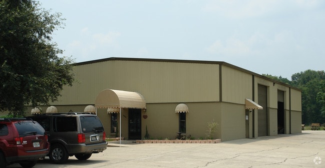

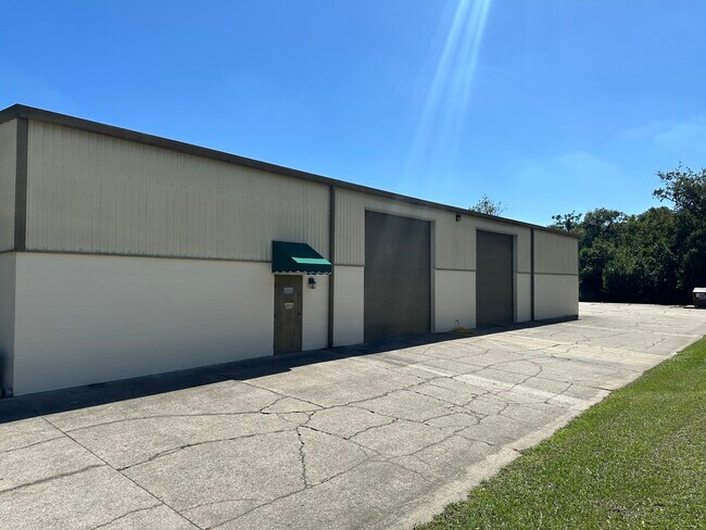
Property Detail
4060 Se 45Th Ct
3134-003-005
SEC 35 TWP 15 RGE 22 PLAT BOOK X PAGE 007 SOUTH OCALA INDUSTRIAL COMPLEX BLK C LOT 5
Warehouse
Marion
M1
Florida
B and X Area of moderate flood hazard, usually the area between the limits of the 100-year and 500-year floods.
5
2025
0.62 AC
2025
Outlying Marion County
001103
Ocala
5,000 SF
Ocala, FL
NEARBY LISTINGS FOR SALE OR LEASE
DEMOGRAPHICS near 4060 Se 45Th Ct
1 mile
3 mile
5 mile
2025 Total Population
4,642
47,863
99,397
2030 Population
5,212
53,738
111,860
Pop Growth 2025-2030
+ 12.28%
+ 12.27%
+ 12.54%
Average Age
38
41
41
2025 Total Households
1,668
18,323
39,778
HH Growth 2025-2030
+ 12.53%
+ 12.56%
+ 12.85%
Median Household Inc
$101,923
$74,379
$65,040
Avg Household Size
2.70
2.60
2.40
2025 Avg HH Vehicles
2.00
2.00
2.00
Median Home Value
$356,622
$273,225
$267,703
Median Year Built
1991
1990
1987
Nearby Places
Map Layers
Map Styles
 Street
 Aerial
Layers
 Traffic
 Biking
Places
Listings with unknown addresses are not visible on the map
- Restaurants
- Banks
- Shops
- Fitness
- Groceries
SALE & LEASE HISTORY
LISTING DATE
SALE/LEASE

Oct 13, 2025
For Sale
Nearby Properties
Address
Land Use
TOTAL SIZE
Lot Size
Zoning
Address
Land Use
TOTAL SIZE
Lot Size
Zoning
189,025 SF
35.42 AC
PD08
Address
Land Use
TOTAL SIZE
Lot Size
Zoning
211,884 SF
80 AC
GU
Address
Land Use
TOTAL SIZE
Lot Size
Zoning
88,462 SF
31.76 AC
INST
Address
Land Use
TOTAL SIZE
Lot Size
Zoning
89,719 SF
15.16 AC
PD12
Address
Land Use
TOTAL SIZE
Lot Size
Zoning
56,484 SF
12.50 AC
PD14
Address
Land Use
TOTAL SIZE
Lot Size
Zoning
5,815 SF
186.33 AC
GU
Address
Land Use
TOTAL SIZE
Lot Size
Zoning
132,214 SF
40 AC
GU
Address
Land Use
TOTAL SIZE
Lot Size
Zoning
71,065 SF
12.01 AC
B2
Address
Land Use
TOTAL SIZE
Lot Size
Zoning
49,963 SF
9.84 AC
PD14
Address
Land Use
TOTAL SIZE
Lot Size
Zoning
60,710 SF
66.65 AC
A1
Address
Land Use
TOTAL SIZE
Lot Size
Zoning
58,040 SF
10.24 AC
INST
Address
Land Use
TOTAL SIZE
Lot Size
Zoning
68,182 SF
22.64 AC
A1
Address
Land Use
TOTAL SIZE
Lot Size
Zoning
70,325 SF
11.62 AC
PD14
Address
Land Use
TOTAL SIZE
Lot Size
Zoning
34,531 SF
3.13 AC
R3
Address
Land Use
TOTAL SIZE
Lot Size
Zoning
390,591 SF
30.62 AC
M2
Address
Land Use
TOTAL SIZE
Lot Size
Zoning
64,190 SF
17.71 AC
INST
Address
Land Use
TOTAL SIZE
Lot Size
Zoning
70,667 SF
20.30 AC
INST
Address
Land Use
TOTAL SIZE
Lot Size
Zoning
268,173 SF
18.70 AC
M2
Address
Land Use
TOTAL SIZE
Lot Size
Zoning
60,576 SF
20.47 AC
INST
Address
Land Use
TOTAL SIZE
Lot Size
Zoning
48,299 SF
9.10 AC
B1
Address
Land Use
TOTAL SIZE
Lot Size
Zoning
65,444 SF
12.17 AC
M1
Address
Land Use
TOTAL SIZE
Lot Size
Zoning
26,020 SF
10.46 AC
B2
Address
Land Use
TOTAL SIZE
Lot Size
Zoning
11,705 SF
4.38 AC
INST
Address
Land Use
TOTAL SIZE
Lot Size
Zoning
64,020 SF
9.08 AC
B5
Address
Land Use
TOTAL SIZE
Lot Size
Zoning
31,638 SF
16.27 AC
INST
Address
Land Use
TOTAL SIZE
Lot Size
Zoning
28,134 SF
12.27 AC
B2
Address
Land Use
TOTAL SIZE
Lot Size
Zoning
682 SF
468.13 AC
A1
Address
Land Use
TOTAL SIZE
Lot Size
Zoning
11,216 SF
2.55 AC
O1
Address
Land Use
TOTAL SIZE
Lot Size
Zoning
75,000 SF
20.66 AC
M1
Address
Land Use
TOTAL SIZE
Lot Size
Zoning
93,120 SF
34.47 AC
PUD
The World's #1 Commercial Real Estate Marketplace
Connect with us
© 2026 CoStar Group
The information above has been obtained from sources believed reliable. While we do not doubt its accuracy we have not verified it and make no guarantee, warranty or representation about it. It is your responsibility to independently confirm its accuracy and completeness. Any projections, opinions, assumptions, or estimates used are for example only and do not represent the current or future performance of the property. The value of this transaction to you depends on tax and other factors which should be evaluated by your tax, financial, and legal advisors. You and your advisors should conduct a careful, independent investigation of the property to determine to your satisfaction the suitability of the property for your needs.